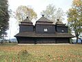
Category:Church of Saint Michael Archangel in Smolnik
Jump to navigation
Jump to search
| Object location | | View all coordinates using: OpenStreetMap |
|---|
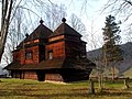
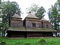
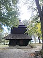
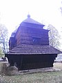
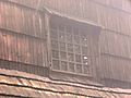
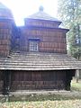
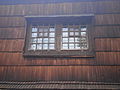
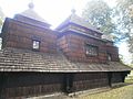
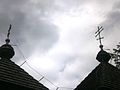
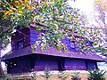
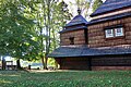
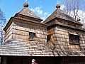
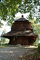
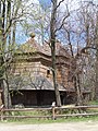
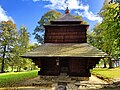
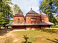
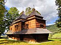
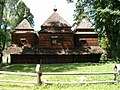
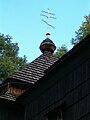
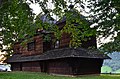
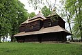
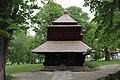
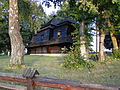
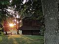
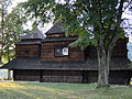
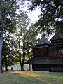
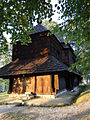
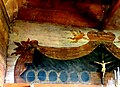
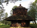
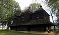
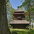
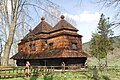
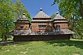
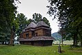
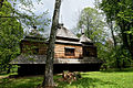
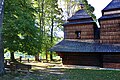
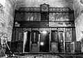
a Gothic, wooden church located in the village of Smolnik from the eighteenth-century .jpg) | |||||
| Upload media | |||||
| Instance of | |||||
|---|---|---|---|---|---|
| Part of | |||||
| Location | Smolnik, Bieszczady County, Gmina Lutowiska, Bieszczady County, Subcarpathian Voivodeship, Poland | ||||
| Diocese | |||||
| Heritage designation |
| ||||
| Inception |
| ||||
| Date of official closure |
| ||||
| Area |
| ||||
| Religion or worldview | |||||
 | |||||
Media in category "Church of Saint Michael Archangel in Smolnik"
The following 167 files are in this category, out of 167 total.
-
 24 Smolnik (27).JPG 3,216 × 4,288; 3.2 MB
-
 Cerkiew bojkowska Smolnik.JPG 3,072 × 2,304; 5.65 MB
-
 Cerkiew bojkowska w Smolniku z 1791 r krz.JPG 2,048 × 1,536; 1,015 KB
-
 Cerkiew Smolnik (1).JPG 3,216 × 4,288; 3.33 MB
-
 Cerkiew Smolnik (10).JPG 4,288 × 3,216; 3.59 MB
-
 Cerkiew Smolnik (11).JPG 3,216 × 4,288; 3.5 MB
-
 Cerkiew Smolnik (12).JPG 3,216 × 4,288; 3.62 MB
-
 Cerkiew Smolnik (13).JPG 3,216 × 4,288; 3.07 MB
-
 Cerkiew Smolnik (14).JPG 3,216 × 4,288; 3.16 MB
-
 Cerkiew Smolnik (15).JPG 4,288 × 3,216; 3.4 MB
-
 Cerkiew Smolnik (16).JPG 3,216 × 4,288; 3.03 MB
-
 Cerkiew Smolnik (18).JPG 4,288 × 3,216; 3.5 MB
-
 Cerkiew Smolnik (19).JPG 4,288 × 3,216; 2.89 MB
-
 Cerkiew Smolnik (2).JPG 3,216 × 4,288; 2.81 MB
-
 Cerkiew Smolnik (20).JPG 3,216 × 4,288; 2.99 MB
-
 Cerkiew Smolnik (21).JPG 3,216 × 4,288; 3.22 MB
-
 Cerkiew Smolnik (22).JPG 4,288 × 3,216; 3.41 MB
-
 Cerkiew Smolnik (23).JPG 3,216 × 4,288; 3.3 MB
-
 Cerkiew Smolnik (24).JPG 4,288 × 3,216; 3.03 MB
-
 Cerkiew Smolnik (26).JPG 4,288 × 3,216; 3.31 MB
-
 Cerkiew Smolnik (28).JPG 4,288 × 3,216; 4.64 MB
-
 Cerkiew Smolnik (29).JPG 3,216 × 4,288; 3.56 MB
-
 Cerkiew Smolnik (3).JPG 4,288 × 3,216; 2.96 MB
-
 Cerkiew Smolnik (30).JPG 3,216 × 4,288; 2.97 MB
-
 Cerkiew Smolnik (31).JPG 3,216 × 4,288; 3.5 MB
-
 Cerkiew Smolnik (32).JPG 3,216 × 4,288; 2.81 MB
-
 Cerkiew Smolnik (33).JPG 4,288 × 3,216; 3.08 MB
-
 Cerkiew Smolnik (34).JPG 3,216 × 4,288; 3.11 MB
-
 Cerkiew Smolnik (36).JPG 3,216 × 4,288; 3.34 MB
-
 Cerkiew Smolnik (37).JPG 3,216 × 4,288; 3.21 MB
-
 Cerkiew Smolnik (38).JPG 3,216 × 4,288; 2.82 MB
-
 Cerkiew Smolnik (39).JPG 4,288 × 3,216; 3.18 MB
-
 Cerkiew Smolnik (4).JPG 4,288 × 3,216; 2.72 MB
-
 Cerkiew Smolnik (40).JPG 3,216 × 4,288; 3.29 MB
-
 Cerkiew Smolnik (44).JPG 4,288 × 3,216; 2.91 MB
-
 Cerkiew Smolnik (45).JPG 3,216 × 4,288; 4.21 MB
-
 Cerkiew Smolnik (46).JPG 3,216 × 4,288; 3.16 MB
-
 Cerkiew Smolnik (47).JPG 3,216 × 4,288; 3.19 MB
-
 Cerkiew Smolnik (5).JPG 4,288 × 3,216; 3.04 MB
-
 Cerkiew Smolnik (50).JPG 3,216 × 4,288; 3.07 MB
-
 Cerkiew Smolnik (51).JPG 3,216 × 4,288; 3.11 MB
-
 Cerkiew Smolnik (6).JPG 4,288 × 3,216; 3.1 MB
-
 Cerkiew Smolnik (7).JPG 4,288 × 3,216; 3.33 MB
-
 Cerkiew Smolnik (8).JPG 4,288 × 3,216; 3.16 MB
-
 Cerkiew Smolnik (9).JPG 4,288 × 3,216; 3.1 MB
-
 Cerkiew w Smolnik.jpg 5,184 × 3,456; 16.55 MB
-
 Cerkiew w Smolniku - wnętrze.jpg 1,000 × 667; 269 KB
-
 Cerkiew w Smolniku 2.jpg 2,304 × 1,728; 1.27 MB
-
 Cerkiew w Smolniku nad Sanem.jpg 1,701 × 1,143; 1.64 MB
-
 Cerkiew w Smolniku.JPG 1,728 × 2,304; 1.26 MB
-
 Cerkiew w Smolniku.jpg 1,728 × 2,304; 1.59 MB
-
 Cerkiew św. Michała Archanioła Smolnik.jpg 5,184 × 3,456; 14.75 MB
-
 Cerkiew św. Michała Archanioła w Smolniku (1).jpg 4,928 × 3,264; 3.44 MB
-
 Cerkiew św. Michała Archanioła w Smolniku (18).jpg 4,928 × 3,264; 7.84 MB
-
 Cerkiew św. Michała Archanioła w Smolniku (21).jpg 4,928 × 3,264; 4.45 MB
-
 Cerkiew św. Michała Archanioła w Smolniku widok od frontu.jpg 2,592 × 3,872; 3.9 MB
-
 Cerkiew św. Michała Archanioła w Smolniku widok z boku.jpg 3,872 × 2,592; 5.76 MB
-
 Cerkiew św. Michała Archanioła w Smolniku, detal.jpg 3,500 × 1,969; 5.17 MB
-
 Cerkiew św. Michała Archanioła w Smolniku, krzyż.jpg 3,500 × 2,333; 9.25 MB
-
 Cerkiew św. Michała Archanioła w Smolniku, wnętrze.jpg 3,500 × 2,333; 6.7 MB
-
 Cerkiew św. Michała Archanioła w Smolniku, zima.jpg 3,500 × 1,969; 8.02 MB
-
 Cerkiew św. Michała Archanioła w Smolniku. 2020r.jpg 3,648 × 2,048; 1.5 MB
-
 Cerkiew św. Michała Archanioła w Smolniku.jpg 3,872 × 2,592; 6.1 MB
-
 Cerkiew-Smolnik.JPG 1,728 × 2,304; 1.64 MB
-
 Cerkiew-zniwiarz15.jpg 2,048 × 1,536; 1.39 MB
-
 Church of Saint Michael Archangel in Smolnik, 2023 01.jpg 4,000 × 3,000; 5.72 MB
-
 Church of Saint Michael Archangel in Smolnik, 2023 02.jpg 4,000 × 3,000; 4.07 MB
-
 Church of Saint Michael Archangel in Smolnik, 2023 03.jpg 3,264 × 2,448; 3.89 MB
-
 Church of Saint Michael Archangel in Smolnik, 2023 04.jpg 4,000 × 3,000; 4.98 MB
-
 Church of Saint Michael Archangel in Smolnik, 2023 05.jpg 4,000 × 3,000; 3.35 MB
-
 Church of Saint Michael Archangel in Smolnik, 2023 06.jpg 4,000 × 3,000; 4.46 MB
-
 Church of Saint Michael Archangel in Smolnik, 2023 07.jpg 4,000 × 3,000; 3 MB
-
 Church of Saint Michael Archangel in Smolnik, 2023 08.jpg 4,000 × 3,000; 5.08 MB
-
 Church of Saint Michael Archangel in Smolnik, 2023 09.jpg 3,000 × 4,000; 6.29 MB
-
 Church of Saint Michael Archangel in Smolnik, 2023 10.jpg 3,000 × 4,000; 4.65 MB
-
 Church of Saint Michael Archangel in Smolnik, 2023 11.jpg 4,000 × 3,000; 6.89 MB
-
 Church of Saint Michael Archangel in Smolnik, 2023 12.jpg 2,448 × 3,264; 1.98 MB
-
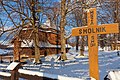
 Drogowskaz 900m w lewo do Smolnik - cerkiew.jpg 3,072 × 2,304; 4.53 MB
-

-
 Kościół św. Michała Archanioła w Smolniku.jpg 3,456 × 5,184; 15.57 MB
-
 Poland Smolnik - wooden church.jpg 3,008 × 2,000; 813 KB
-
 Poland Smolnik - wooden church2.jpg 2,048 × 1,536; 1.73 MB
-
 Poland Smolnik - wooden church3.jpg 2,048 × 1,536; 1.7 MB
-
 Poland Smolnik - wooden church4.jpg 1,536 × 2,048; 1.1 MB
-
 Poland Smolnik - wooden church5.jpg 2,048 × 1,536; 1.09 MB
-
 SM Smolnik Cerkiew św Michała Archanioła 2020 (6).jpg 5,278 × 3,519; 12.99 MB
-
 SM Smolnik Cerkiew św Michała Archanioła 2020 (9).jpg 5,132 × 3,421; 13.24 MB
-
 Smolnik (powiat bieszczadzki) - cerkiew.jpg 600 × 450; 81 KB
-
 Smolnik - cerkiew bojkowska.jpg 3,696 × 2,448; 4.92 MB
-
 Smolnik - cerkiew tablica mapa.jpg 3,072 × 2,304; 5.01 MB
-
 Smolnik - cerkiew tablica.jpg 3,072 × 2,304; 4.96 MB
-
 Smolnik - kościół (01).jpg 3,000 × 4,000; 3.55 MB
-
 Smolnik - kościół (02).jpg 4,000 × 3,000; 2.47 MB
-
 Smolnik - kościół (03).jpg 3,000 × 4,000; 3.1 MB
-
 Smolnik - kościół (04).jpg 3,000 × 4,000; 1.6 MB
-
 Smolnik - kościół (05).jpg 4,000 × 3,000; 2.77 MB
-
 Smolnik - kościół (06).jpg 3,225 × 2,421; 2.33 MB
-
 Smolnik - kościół (07).jpg 3,000 × 4,000; 2.55 MB
-
 Smolnik cerkiew 01.jpg 6,000 × 4,000; 12 MB
-
 Smolnik cerkiew 02.jpg 6,000 × 4,000; 11.31 MB
-
 Smolnik cerkiew 03.jpg 6,000 × 4,000; 9.04 MB
-
 Smolnik cerkiew 04.jpg 6,000 × 4,000; 11.78 MB
-
 Smolnik cerkiew 05.jpg 6,000 × 4,000; 12.39 MB
-
 Smolnik cerkiew 06.jpg 6,000 × 4,000; 10.64 MB
-
 Smolnik cerkiew 07.jpg 4,000 × 6,000; 11.7 MB
-
 Smolnik cerkiew 08.jpg 4,000 × 6,000; 12.39 MB
-
 Smolnik cerkiew 10.JPG 3,456 × 2,592; 4.02 MB
-
 Smolnik cerkiew 11.JPG 2,423 × 3,340; 1.74 MB
-
 Smolnik cerkiew 12.JPG 2,592 × 3,456; 3.16 MB
-
 Smolnik cerkiew 2.JPG 3,456 × 2,592; 1.46 MB
-
 Smolnik cerkiew 3.JPG 3,456 × 2,592; 3.87 MB
-
 Smolnik cerkiew 4.JPG 3,456 × 2,592; 3.92 MB
-
 Smolnik cerkiew 5.JPG 2,592 × 3,456; 3.16 MB
-
 Smolnik cerkiew 6.JPG 3,358 × 2,468; 1.28 MB
-
 Smolnik cerkiew 7.JPG 2,592 × 3,456; 3.18 MB
-
 Smolnik cerkiew 8.JPG 2,475 × 3,353; 1.44 MB
-
 Smolnik cerkiew 9.JPG 3,456 × 2,592; 3.92 MB
-
 Smolnik cerkiew Michała Archanioła 1.JPG 3,456 × 2,592; 3.91 MB
-
 Smolnik Drogowskaz 900m w lewo do Smolnik - cerkiew.jpg 800 × 329; 235 KB
-
 Smolnik nad Sanem. Cerkiew św. Michała Archanioła 1.jpg 1,106 × 825; 321 KB
-
 Smolnik nad Sanem. Cerkiew św. Michała Archanioła 10.jpg 1,063 × 771; 466 KB
-
 Smolnik nad Sanem. Cerkiew św. Michała Archanioła 11.jpg 1,200 × 900; 639 KB
-
 Smolnik nad Sanem. Cerkiew św. Michała Archanioła 12.jpg 1,192 × 882; 488 KB
-
 Smolnik nad Sanem. Cerkiew św. Michała Archanioła 13.jpg 1,192 × 886; 508 KB
-
 Smolnik nad Sanem. Cerkiew św. Michała Archanioła 14.jpg 1,191 × 879; 592 KB
-
 Smolnik nad Sanem. Cerkiew św. Michała Archanioła 2.jpg 529 × 682; 171 KB
-
 Smolnik nad Sanem. Cerkiew św. Michała Archanioła 3.jpg 597 × 747; 183 KB
-
 Smolnik nad Sanem. Cerkiew św. Michała Archanioła 4.jpg 558 × 700; 138 KB
-
 Smolnik nad Sanem. Cerkiew św. Michała Archanioła 5.jpg 820 × 1,007; 249 KB
-
 Smolnik nad Sanem. Cerkiew św. Michała Archanioła 6.jpg 791 × 1,046; 267 KB
-
 Smolnik nad Sanem. Cerkiew św. Michała Archanioła 7.jpg 804 × 1,095; 349 KB
-
 Smolnik nad Sanem. Cerkiew św. Michała Archanioła 8.jpg 1,174 × 800; 274 KB
-
 Smolnik nad Sanem. Cerkiew św. Michała Archanioła 9.jpg 1,160 × 842; 295 KB
-
 Smolnik nad Sanem.JPG 3,072 × 2,304; 3.14 MB
-
 Smolnik, cerkiew gr.-kat. 01.JPG 4,000 × 2,197; 7.41 MB
-
 Smolnik, cerkiew gr.-kat. 02.JPG 2,853 × 2,841; 4.85 MB
-
 Smolnik, cerkiew gr.-kat. 03.JPG 4,000 × 3,000; 8.19 MB
-
 Smolnik, cerkiew gr.-kat. 04.JPG 3,697 × 2,246; 5.62 MB
-
 Smolnik, cerkiew gr.-kat. 05.JPG 4,000 × 2,234; 5.79 MB
-
 Smolnik, cerkiew gr.-kat. 06.JPG 4,000 × 2,391; 5.51 MB
-
 Smolnik, cerkiew gr.-kat., wnętrze.JPG 4,000 × 3,000; 8.27 MB
-
 Smolnik, cerkiew św. Michała Archanioła (HB1).jpg 2,500 × 1,787; 4.61 MB
-
 Smolnik, cerkiew św. Michała Archanioła (HB10).jpg 3,857 × 2,571; 5.86 MB
-
 Smolnik, cerkiew św. Michała Archanioła (HB11).jpg 2,506 × 2,506; 3.88 MB
-
 Smolnik, cerkiew św. Michała Archanioła (HB12).jpg 2,872 × 2,872; 5.37 MB
-
 Smolnik, cerkiew św. Michała Archanioła (HB13).jpg 2,789 × 2,789; 5.26 MB
-
 Smolnik, cerkiew św. Michała Archanioła (HB14).jpg 4,328 × 2,885; 9.08 MB
-
 Smolnik, cerkiew św. Michała Archanioła (HB15).jpg 2,250 × 2,250; 3.34 MB
-
 Smolnik, cerkiew św. Michała Archanioła (HB16).jpg 2,868 × 2,868; 4.28 MB
-
 Smolnik, cerkiew św. Michała Archanioła (HB2).jpg 2,567 × 1,804; 4.48 MB
-
 Smolnik, cerkiew św. Michała Archanioła (HB3).jpg 2,180 × 1,458; 3.01 MB
-
 Smolnik, cerkiew św. Michała Archanioła (HB4).jpg 2,771 × 1,742; 4.69 MB
-
 Smolnik, cerkiew św. Michała Archanioła (HB5).jpg 2,232 × 1,451; 3.52 MB
-
 Smolnik, cerkiew św. Michała Archanioła (HB6).jpg 2,435 × 1,876; 3.25 MB
-
 Smolnik, cerkiew św. Michała Archanioła (HB7).jpg 2,377 × 1,828; 2.04 MB
-
 Smolnik, cerkiew św. Michała Archanioła (HB8).jpg 4,371 × 2,914; 6.43 MB
-
 Smolnik, cerkiew św. Michała Archanioła (HB9).jpg 4,097 × 2,731; 5.47 MB
-
 Smolnik, Cerkiew św. Michała Archanioła w Smolniku DZolopa 2021-07-11 170356 0358.jpg 2,792 × 1,861; 1.07 MB
-
 Smolnik, Cerkiew św. Michała Archanioła w Smolniku DZolopa 2021-07-11 171053 0361.jpg 2,792 × 1,861; 1.04 MB
-
 Smolnik, Cerkiew św. Michała Archanioła w Smolniku.jpg 2,348 × 1,565; 2.52 MB
-
 Smolnik, cerkiew św. Michała Archanioła, cis Benedykta XVI (HB17).jpg 3,871 × 2,903; 10.29 MB
-
 Smolnik, cmentarz.JPG 4,000 × 3,000; 9.33 MB
-
 Smolnik..jpg 1,600 × 1,066; 2.01 MB
-
 Smolnik.jpg 1,600 × 1,066; 978 KB
-
 Wooden church near Smolnik 18-6-2007 - panoramio.jpg 850 × 638; 238 KB
-
 Zabytkowa cerkiew w Smolniku.jpg 5,184 × 3,456; 15.38 MB
-
 Zniszczony ikonostas w cerkwi św. Archanioła Michała w Smolniku.jpg 575 × 401; 202 KB
.JPG)


.JPG)
.JPG)
.JPG)
.JPG)
.JPG)
.JPG)
.JPG)
.JPG)
.JPG)
.JPG)
.JPG)
.JPG)
.JPG)
.JPG)
.JPG)
.JPG)
.JPG)
.JPG)
.JPG)
.JPG)
.JPG)
.JPG)
.JPG)
.JPG)
.JPG)
.JPG)
.JPG)
.JPG)
.JPG)
.JPG)
.JPG)
.JPG)
.JPG)
.JPG)
.JPG)
.JPG)
.JPG)
.JPG)
.JPG)
.JPG)
.JPG)
.JPG)


.jpg)
.jpg)


.jpg)
.jpg)
_-_cerkiew.jpg)


.jpg)
.jpg)
.jpg)
.jpg)
.jpg)
.jpg)
.jpg)


.jpg)
.jpg)
.jpg)
.jpg)
.jpg)
.jpg)
.jpg)
.jpg)
.jpg)
.jpg)
.jpg)
.jpg)
.jpg)
.jpg)
.jpg)
.jpg)


.jpg)


Categories:
- Churches in powiat bieszczadzki
- Wooden churches in Subcarpathian Voivodeship
- Greek Catholic churches in Subcarpathian Voivodeship
- Saint Michael Archangel churches in Subcarpathian Voivodeship
- Buildings in Smolnik (powiat bieszczadzki)
- Cultural heritage monuments in gmina Lutowiska
- Wooden tserkvas of Carpathian region in Poland and Ukraine
- Churches in Dekanat Lutowiska