Файл:1630 Hondius Map of Virginia and the Chesapeake - Geographicus - NovaVirginiaeTabula-hondius-1630.jpg
Перейти к навигации
Перейти к поиску
Размер этого предпросмотра: 770 × 600 пкс. Другие разрешения: 308 × 240 пкс | 616 × 480 пкс | 986 × 768 пкс | 1280 × 997 пкс | 2560 × 1994 пкс | 4000 × 3116 пкс.
Исходный файл (4000 × 3116 пкс, размер файла: 4,23 МБ, MIME-тип: image/jpeg)
Этот файл находится на Викискладе. Сведения о нём показаны ниже.
Викисклад — централизованное хранилище для свободных файлов, используемых в проектах Викимедиа.
|
| Nova Virginiae Tabula. | ||||||
|---|---|---|---|---|---|---|
| Автор | ||||||
| Название |
Nova Virginiae Tabula. |
|||||
| Описание |
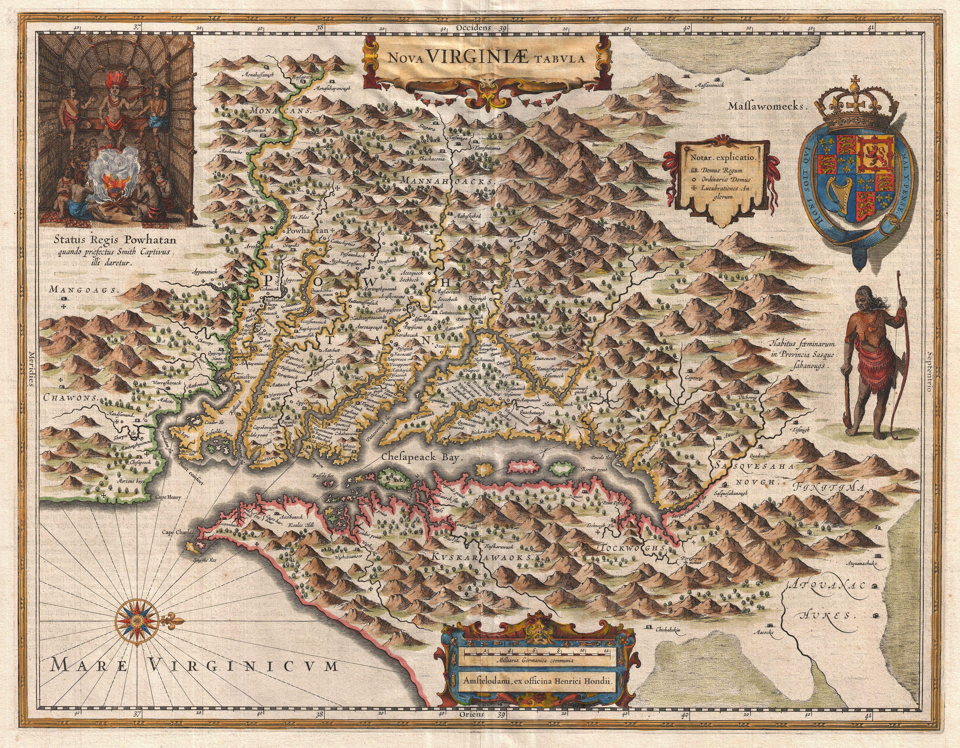
English: A very fine example of Henricus Hondius’ 1630 map of the Virginia colony and the Chesapeake Bay. Oriented to the west, this map covers from Cape Henry to the Susquehanna River and inland as far as the Appalachian Mountains. The Chesapeake Bay is shown in full as are many of its river estuaries, though topographically this map places a number of mountain ranges where there are in fact none. Cartographically this map is based upon John Smith’s landmark map of the Virginia colony issued in 1612. Smith’s fine survey work, as well as reports from indigenous American Indian tribes, and fanciful wishful thinking, combine to make this one of the most interesting maps of America to emerge in the 17th century. Philip D. Burden, the author of The Mapping of America, considers this map, Nova Virginiae Tabula , to be one of the most important maps of America ever produced and certainly one of the greatest influence. To fully understand this map one must first realize that most Europeans believed the Pacific, or at least some great bay that led to the Pacific, lay just a few days travel inland. In the minds of most Europeans of the period, the trade potential for the Virginia colony was entirely dependent upon it being a practical access point to the riches of Asia. Thus the significance of large and mysterious body of water appearing in the land of the Massawomecks, in the upper right quadrant, becomes apparent. Of course, much of this land was entirely unexplored by the European settlers in Jamestown, shown here on the Powhatan River (James River), who relied heavily upon American Indian reports for much of their cartographic knowledge of the Virginia hinterlands. The Masawomecks themselves were a rival of the Powhatan and made their home near the headwaters of the Potomac. These, like many other indigenous groups of the region made only a brief and frequently violent appearance during the 17th century before entirely disappearing, mostly from disease and war, in the early 18th century. In the upper left quadrant there is an image of the American Indian chief of the Powhatan sitting enthroned before a great fire in his long house. One of the more popular legends regarding John Smith was is capture and trial before the chief of the Powahatan. Smith was convinced that his liberation had something to do with the youthful daughter of Chief Powahatan, Pocahontas, taking a liking to him. Though this grew into a fictious legend of its own, the truth is more likely that Powhatan saw Smith and his Englishmen as potential allies against the rival American Indian groups, such as the Massawomecks, that were pressing hard against his borders. There are a number of different editions of this map and its publication by various map houses in various states made it the first widely distributed map of the Virginia colony and of John Smith’s important map. There was, however, a scandal relating to its publication. The map was originally drawn and engraved in 1618 by Jodocus Hondius based upon the first edition of John Smith’s 1612 map. When Jodocus died in 1629, he and his brother, Henricus Hondius, while collaborating on the Hondius Atlas Major , had established and maintained separate business for some 10 years. Jodocus’ death enabled the competing cartographer, Willem Blaeu to acquire a large number of Jodocus’ map plates, which he promptly published in 1630 as the Atlantis Appendix . Henricus, in the meantime, had been counting on Jodocus’ new plates to enhance his own, by then outdated, Hondius Atlas Major . A surviving contract dated March 2, 1630 reveals that Henricus Hondius and his partner Joannes Janssonius hired engravers to produce a number of new map plates copying the work of Jodocus – now in the hands of the Blaeu firm. This map was among the most important on that list and accounts for the quantity of variants of this map issued by competing Blaeu and Hondius firms. |
|||||
| Дата | 1630 (undated) | |||||
| Размеры | высота: 15,5 дюймов (39,3 см); ширина: 19,5 дюймов (49,5 см) | |||||
| Инвентарный номер |
Geographicus link: NovaVirginiaeTabula-hondius-1630 |
|||||
| Источник/Фотограф |
Hondius, H., Atlas Major, 1630.
|
|||||
| Права (Повторное использование этого файла) |
|
|||||
| Аннотации | Это изображение аннотировано: Просмотреть аннотации на Викискладе |
История файла
Нажмите на дату/время, чтобы посмотреть файл, который был загружен в тот момент.
| Дата/время | Миниатюра | Размеры | Участник | Примечание | |
|---|---|---|---|---|---|
| текущий | 07:58, 25 марта 2011 | | 4000 × 3116 (4,23 МБ) | BotMultichillT | {{subst:User:Multichill/Geographicus |link=http://www.geographicus.com/P/AntiqueMap/NovaVirginiaeTabula-hondius-1630 |product_name=1630 Hondius Map of Virginia and the Chesapeake |map_title=Nova Virginiae Tabula. |description=A very fine example of Henric |
Использование файла
Нет страниц, использующих этот файл.
Глобальное использование файла
Данный файл используется в следующих вики:
- Использование в ast.wikipedia.org
- Использование в cs.wikipedia.org
- Использование в en.wikipedia.org
- Использование в hy.wikipedia.org
- Использование в nl.wikipedia.org
- Использование в sr.wikipedia.org
- Использование в ur.wikipedia.org