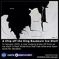
Файл:A Chip off the King Baudouin Ice Shelf (16278813147).jpg

Исходный файл (640 × 640 пкс, размер файла: 78 КБ, MIME-тип: image/jpeg)
Этот файл находится на Викискладе. Сведения о нём показаны ниже.
Викисклад — централизованное хранилище для свободных файлов, используемых в проектах Викимедиа.
Сообщить об ошибке с файлом |
Краткое описание
| ОписаниеA Chip off the King Baudouin Ice Shelf (16278813147).jpg |
While large icebergs calve regularly from fast-flowing ice shelves in West Antarctica, the coast of cooler, drier East Antarctica tends to be less active. That made it a mild surprise when a 70-square-kilometer chunk of ice broke off from the King Baudouin Ice Shelf in January 2015. The last time that part of King Baudouin calved such a large iceberg was in the 1960s. A growing rift near the edge of the glacier was visible to satellites for several weeks before the ice finally broke loose. The Operational Land Imager (OLI) on Landsat 8 acquired this image on January 24, 2015. While clouds obscured Landsat 8’s view of the new berg after January 25, a radar aboard the European Space Agency’s Sentinel-1 satellite captured an image of the iceberg on January 28, showing it moving away from the ice shelf. The new iceberg is now drifting in Breid Bay off of Queen Maud Land. The formation of new icebergs from ice shelves is a normal process. Ice shelves are platforms of floating ice that extend out over the water from ice sheets on land. As snow falls adds mass to the ice sheet, its glaciers flow naturally seaward and chunks inevitably break off. Since ice shelves are already floating on the ocean, an iceberg that calves from an ice shelf does not affect sea level. Download full resolution and read more at earthobservatory.nasa.gov/IOTD/view.php?id=85235&src=...
The Earth Observatory's mission is to share with the public the images, stories, and discoveries about climate and the environment that emerge from NASA research, including its satellite missions, in-the-field research, and climate models. Like us on Facebook Follow us on Twitter Find us on Instagram Add us to your circles on Google+ |
| Дата | |
| Источник | A Chip off the King Baudouin Ice Shelf |
| Автор | NASA's Earth Observatory |
| Другие версии | Производные работы от этого файла: A Chip off the King Baudouin Ice Shelf (16278813147) (cropped).jpg |
| Местоположение камеры | 70° 16′ 46,44″ ю. ш., 28° 16′ 38,77″ в. д. | Это и другие изображения по их местоположению на OpenStreetMap |
|---|
Лицензирование
- Вы можете свободно:
- делиться произведением – копировать, распространять и передавать данное произведение
- создавать производные – переделывать данное произведение
- При соблюдении следующих условий:
- атрибуция – Вы должны указать авторство, предоставить ссылку на лицензию и указать, внёс ли автор какие-либо изменения. Это можно сделать любым разумным способом, но не создавая впечатление, что лицензиат поддерживает вас или использование вами данного произведения.
| Это изображение изначально опубликовано на Flickr участником проекта NASA Earth Observatory по ссылке https://www.flickr.com/photos/68824346@N02/16278813147. Оно было досмотрено 9 февраля 2015 роботом FlickreviewR, который подтвердил, что изображение лицензировано в соответствии с условиями cc-by-2.0. |
9 февраля 2015
Краткие подписи
Элементы, изображённые на этом файле
изображённый объект
У этого свойства есть некоторое значение без элемента в
70°16'46.441"S, 28°16'38.766"E
7 февраля 2015
image/jpeg
009b2ac511bbfd9eccb1aa937965eb57936af1ae
79 886 байт
640 пиксель
640 пиксель
История файла
Нажмите на дату/время, чтобы посмотреть файл, который был загружен в тот момент.
| Дата/время | Миниатюра | Размеры | Участник | Примечание | |
|---|---|---|---|---|---|
| текущий | 09:27, 9 февраля 2015 |  | 640 × 640 (78 КБ) | 4ing | Transferred from Flickr via Flickr2Commons |
Использование файла
Нет страниц, использующих этот файл.
Метаданные
Файл содержит дополнительные данные, обычно добавляемые цифровыми камерами или сканерами. Если файл после создания редактировался, то некоторые параметры могут не соответствовать текущему изображению.
| Примечание JPEG-файла | cmp3.10.3.2Lq3 0x0966c1c1 |
|---|