Файл:A survey of the Northern Neck of Virginia - being the lands belonging to the Rt. Honourable Thomas Lord Fairfax Baron Cameron, bounded by & within the Bay of Chesapoyocke and between the rivers NYPL434003.tiff
Перейти к навигации
Перейти к поиску

Размер этого JPG-превью для исходного TIF-файла: 728 × 599 пкс. Другие разрешения: 292 × 240 пкс | 583 × 480 пкс | 933 × 768 пкс | 1244 × 1024 пкс | 2488 × 2048 пкс | 5899 × 4856 пкс.
Исходный файл (5899 × 4856 пкс, размер файла: 81,96 МБ, MIME-тип: image/tiff)
Этот файл находится на Викискладе. Сведения о нём показаны ниже.
Викисклад — централизованное хранилище для свободных файлов, используемых в проектах Викимедиа.
|
Краткое описание
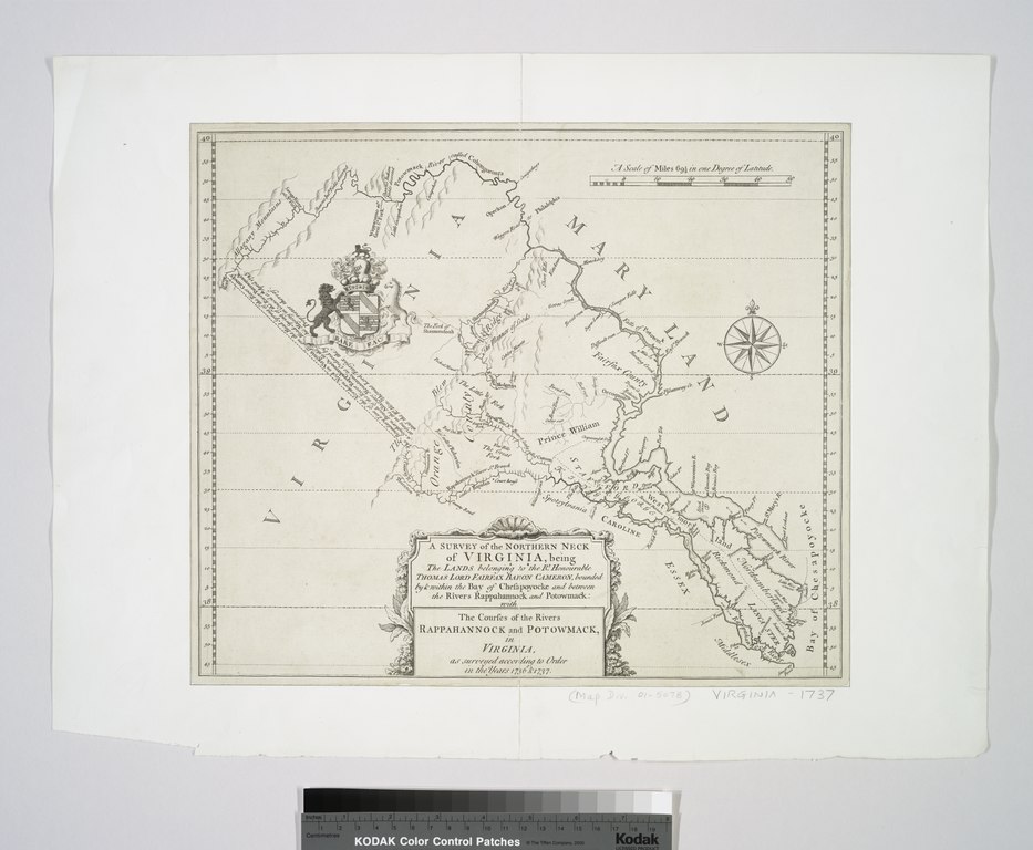
| Описание | A survey of the Northern Neck of Virginia : being the lands belonging to the Rt. Honourable Thomas Lord Fairfax Baron Cameron, bounded by & within the Bay of Chesapoyocke and between the rivers Rappahannock and Potowmack: With the courses of the rivers Rappahannock and Potowmack, in Virginia, as surveyed according to order in the years 1736 & 1737. | |||||||||||||||||||||||
| Notes | "A scale of miles 69 1/2 in one degree of latitude." Note 2.) Author attribution by LC. Note 3.) Emmet Collection ; 7748. Note 4.) National Endowment for the Humanities Grant for Access to Early Maps of the Middle Atlantic Seaboard. Note 5.) Relief shown pictorially. | |||||||||||||||||||||||
| Standard reference | Virginia in maps, 76; EM7748; Phillips. Maps of America, p. 981 | |||||||||||||||||||||||
| Physical description | 1 map ; 30 x 34 cm. | |||||||||||||||||||||||
| Catalog Call Number | Map Div. 01-5078 [Filed with Virginia, 1737] | |||||||||||||||||||||||
| Дата | около 1747 | |||||||||||||||||||||||
| Источник |
http://digitalgallery.nypl.org/nypldigital/dgkeysearchdetail.cfm?imageID=434003
|
|||||||||||||||||||||||
| Автор | Warner, John, fl. 1727-1741 -- Surveyor | |||||||||||||||||||||||
| Права (Повторное использование этого файла) |
From The Lionel Pincus & Princess Firyal Map Division. Released on a CC0 license.[1] | |||||||||||||||||||||||
| Digital ID | 434003 | |||||||||||||||||||||||
| Location | Stephen A. Schwarzman Building / The Lionel Pincus and Princess Firyal Map Division | |||||||||||||||||||||||
| NYPL digital item published | 2-3-2004; updated 3-25-2011 | |||||||||||||||||||||||

Лицензирование
| Этот файл доступен на условиях Creative Commons CC0 1.0 Универсальной передачи в общественное достояние (Universal Public Domain Dedication). | |
| Лица, связанные с работой над этим произведением, решили передать данное произведение в общественное достояние, отказавшись от всех прав на произведение по всему миру в рамках закона об авторских правах (а также связанных и смежных прав), в той степени, которую допускает закон. Вы можете копировать, изменять, распространять, исполнять данное произведение в любых целях, в том числе в коммерческих, без получения на это разрешения автора.
|
Этот документ был создан при поддержке Викимедиа Великобритания.
Чтобы ознакомиться с другими файлами, созданными при поддержке этой организации, посетите, пожалуйста, категорию При поддержке Викимедиа Великобритания.
|
История файла
Нажмите на дату/время, чтобы посмотреть файл, который был загружен в тот момент.
| Дата/время | Миниатюра | Размеры | Участник | Примечание | |
|---|---|---|---|---|---|
| текущий | 04:58, 11 декабря 2017 |  | 5899 × 4856 (81,96 МБ) | Finavon | rotated |
| 04:24, 10 апреля 2014 |  | 4856 × 5899 (81,96 МБ) | Fæ | =={{int:filedesc}}== {{NYPL_map |digital_id = 434003 |standard_reference = Virginia in maps, 76; EM7748; Phillips. Maps of America, p. 981 |record_id = 252856 |catalog_call_number = Map Div. 01-5078 [Filed with Virginia, 1737] |creator = Warner, John,... |
Использование файла
Нет страниц, использующих этот файл.