Файл:Al Hajar Mountains (MODIS 2022-01-14).jpg
Перейти к навигации
Перейти к поиску

Размер этого предпросмотра: 765 × 600 пкс. Другие разрешения: 306 × 240 пкс | 612 × 480 пкс | 980 × 768 пкс | 1280 × 1004 пкс | 2264 × 1775 пкс.
Исходный файл (2264 × 1775 пкс, размер файла: 1,58 МБ, MIME-тип: image/jpeg)
Этот файл находится на Викискладе. Сведения о нём показаны ниже.
Викисклад — централизованное хранилище для свободных файлов, используемых в проектах Викимедиа.
|
.jpg?uselang=ru)
Краткое описание
| Описание |
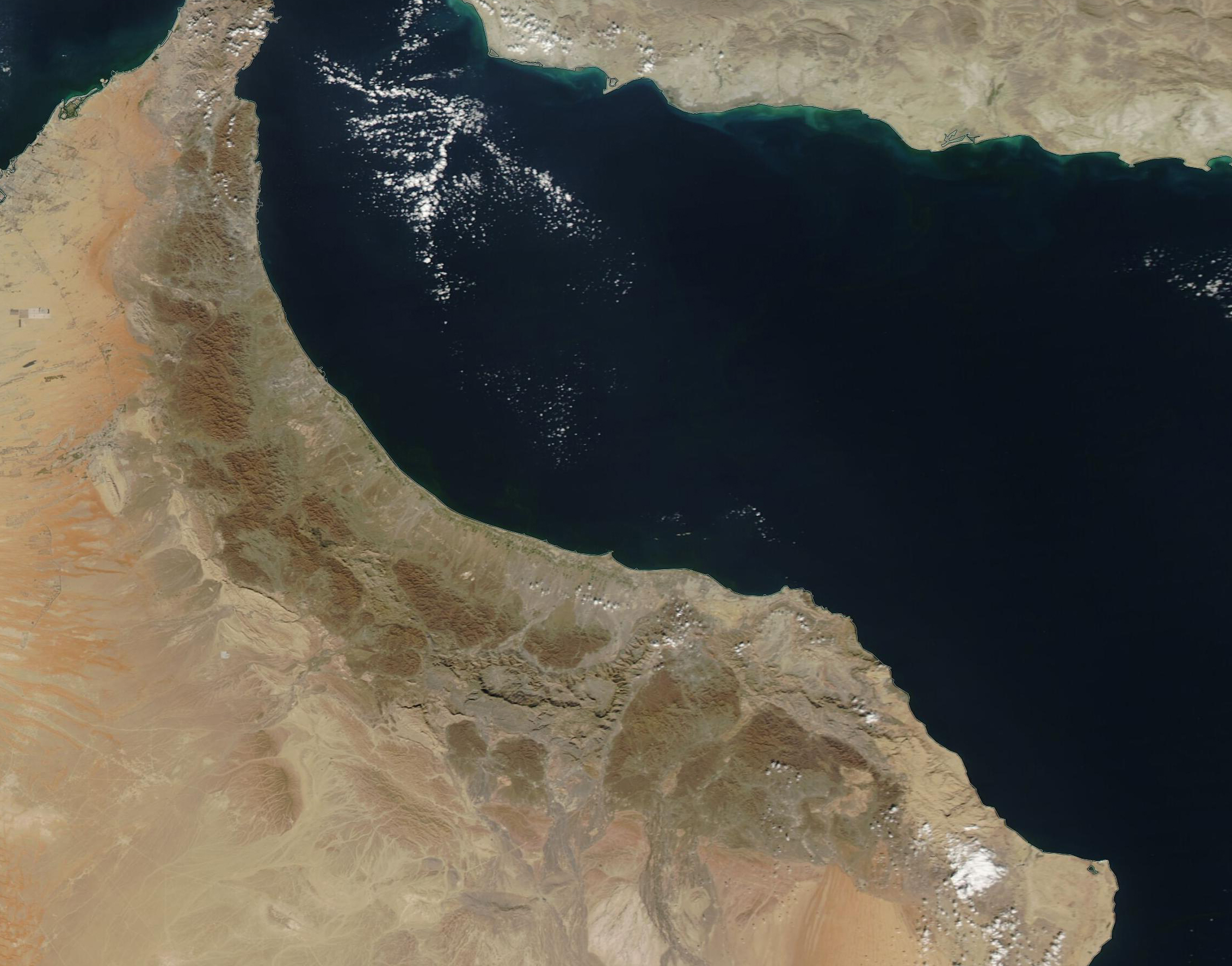
English: The country of Oman sits on the northeastern portion of the Arabian Peninsula, with waters of the Strait of Hormuz, Gulf of Oman, and Arabian Sea lapping along more than 1,200 miles (2,000 km) of coastline. Most of the country is low-lying, hot, dry desert, with extensive sand seas that stretch westward into the neighboring countries of Saudi Arabia and the United Arab Emirates. The northern-most section of Oman, however, contains rugged, high mountains with a climate that supports widespread rich vegetation and even beautiful waterfalls.
On January 10, 2022, the Moderate Resolution Imaging Spectroradiometer (MODIS) on board NASA’s Aqua satellite acquired a true-color image of the dramatic topography of Oman’s Al Hajar Mountains. The dark tans and grays mark rugged outcroppings of the highlands, which contrast strongly against the light tans of the inland desert. Tints of light green cover the mountainous region, marking areas of vegetation. These mountain peaks consist primarily of Cretaceous limestone, a stone created from sediments laid down deep underwater at the time the last dinosaurs roamed the Earth. The mountains also contain igneous rock, which was formed by magma, and metamorphic rock, fashioned under intense heat or pressure. The limestone cliffs of this region support rich soils that give rise to varied vegetation. Plant species change with elevation, and the greatest species diversity appears in the altitude range between 1,000 and 1,500 meters (3,280 and 4,920 feet). |
||
| Дата | Снято: 12 января 2022 | ||
| Источник |
Al Hajar Mountains (direct link)
|
||
| Автор | MODIS Land Rapid Response Team, NASA GSFC |
| This media is a product of the Aqua mission Credit and attribution belongs to the mission team, if not already specified in the "author" row |
Лицензирование
| Этот файл находится в общественном достоянии (англ. public domain), так как он был создан NASA (Национальным управлением по аэронавтике и исследованию космического пространства). Политика авторского права NASA гласит, что «Материал NASA не защищается авторским правом, если не указано иное». (См. Template:PD-USGov, страницу политики авторского права NASA или политику использования изображений JPL.) | ||
 |
Предупреждения:
|
История файла
Нажмите на дату/время, чтобы посмотреть файл, который был загружен в тот момент.
| Дата/время | Миниатюра | Размеры | Участник | Примечание | |
|---|---|---|---|---|---|
| текущий | 22:21, 9 января 2024 | | 2264 × 1775 (1,58 МБ) | OptimusPrimeBot | #Spacemedia - Upload of http://modis.gsfc.nasa.gov/gallery/images/image01142022_250m.jpg via Commons:Spacemedia |
Использование файла
Нет страниц, использующих этот файл.
.jpg)