Файл:Anglo-Turkish Boundary Commission map of Cape Bab el-Mandeb.jpg
Перейти к навигации
Перейти к поиску

Размер этого предпросмотра: 357 × 599 пкс. Другие разрешения: 143 × 240 пкс | 286 × 480 пкс | 457 × 768 пкс | 610 × 1024 пкс | 1731 × 2905 пкс.
Исходный файл (1731 × 2905 пкс, размер файла: 2,93 МБ, MIME-тип: image/jpeg)
Этот файл находится на Викискладе. Сведения о нём показаны ниже.
Викисклад — централизованное хранилище для свободных файлов, используемых в проектах Викимедиа.
|
Краткое описание
| Описание |
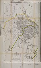
English: Map issued as an annex to the Anglo-Turkish Convention of 3 June 1914. This map of the southwestern tip of the Arabian Peninsula shows the demarcation line agreed upon between 1902 and 1904 by the Anglo-Turkish Boundary Commission which had been tasked to demarcate the respective Ottoman and British spheres of influence in South Arabia. This is one of four maps showing the whole length of the demarcation line drawn by the Commission. The area bordered in yellow, approximately 550 sq. miles, was the area of Yemen that the Turkish government committed not to alienate in any way to a foreign power. Britain was concerned that France, Italy or Germany might attempt to acquire this strategic area facing the British island of Perim at the entrance of the Red Sea. Cape Bab el-Mandeb was also known as Sheikh Said, and is generally known today as Ras Menheli. Français : Carte annexée à la Convention anglo-ottomane du 3 juin 1914 illustrant la ligne de démarcation entre les zones ottomane (à gauche) et britannique à l'extrémité sud-ouest de la péninsule arabique, qui avait été tracée par la Commission de démarcation en 1904. L'extrémité de la péninsule de Cheikh-Saïd est illustrée en gros plan dans le coin inférieur droit. La zone délimitée par une ligne jaune était une zone d'environ 550 miles carrés que la Turquie s'engageait à ne jamais aliéner en faveur d'une puissance étrangère. |
| Дата | |
| Источник | Qatar Digital Library |
| Автор | British War Office, 1914 |
Лицензирование
|
Это произведение находится в общественном достоянии в тех странах, где срок охраны авторского права равен жизни автора плюс 100 лет и менее. | |
| Этот файл был определён как свободный от известных ограничений авторского права, а также связанных и смежных прав. | |
История файла
Нажмите на дату/время, чтобы посмотреть файл, который был загружен в тот момент.
| Дата/время | Миниатюра | Размеры | Участник | Примечание | |
|---|---|---|---|---|---|
| текущий | 16:41, 16 ноября 2015 | | 1731 × 2905 (2,93 МБ) | Lubiesque | User created page with UploadWizard |
Использование файла
Нет страниц, использующих этот файл.
Глобальное использование файла
Данный файл используется в следующих вики:
- Использование в fr.wikipedia.org