Файл:Arrangement, Main Control Room - Haddam Neck Nuclear Power Plant, Service Building, 362 Injun Hollow Road, Haddam, Middlesex County, CT HAER CT-185-F (sheet 3 of 4).png
Перейти к навигации
Перейти к поиску

Размер этого предпросмотра: 800 × 482 пкс. Другие разрешения: 320 × 193 пкс | 640 × 385 пкс | 1024 × 617 пкс | 1280 × 771 пкс | 2560 × 1542 пкс | 21 623 × 13 024 пкс.
Исходный файл (21 623 × 13 024 пкс, размер файла: 8,17 МБ, MIME-тип: image/png)
Этот файл находится на Викискладе. Сведения о нём показаны ниже.
Викисклад — централизованное хранилище для свободных файлов, используемых в проектах Викимедиа.
|
| Это JPEG-версия оригинального файла в формате TIF на File: Arrangement, Main Control Room - Haddam Neck Nuclear Power Plant, Service Building, 362 Injun Hollow Road, Haddam, Middlesex County, CT HAER CT-185-F (sheet 3 of 4).tif.
Однако при сжатии качество изображения несколько уменьшается, поэтому любые изменения нужно согласовывать: сначала осуществлять правку файла в TIF, и лишь потом на его основе обновлять этот файл. Во избежание потери качества не делайте изменения, основанные на этой версии. |
Краткое описание
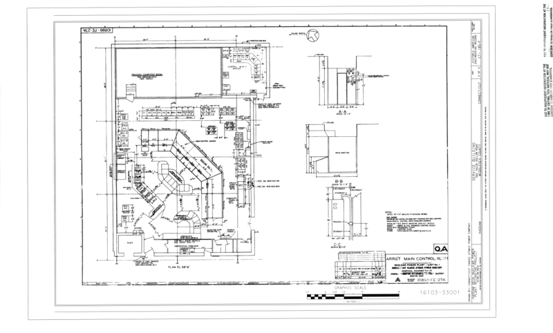
| Arrangement, Main Control Room - Haddam Neck Nuclear Power Plant, Service Building, 362 Injun Hollow Road, Haddam, Middlesex County, CT | ||||
|---|---|---|---|---|
| Фотограф |
Connecticut Yankee Atomic Power Company, creator |
|||
| Название |
Arrangement, Main Control Room - Haddam Neck Nuclear Power Plant, Service Building, 362 Injun Hollow Road, Haddam, Middlesex County, CT |
|||
| Изображённое место | Connecticut; Middlesex County; Haddam | |||
| Дата | Documentation compiled after 1968 | |||
| Размеры | 24 x 36 in. (D size) | |||
| Текущее местонахождение |
Library of Congress Prints and Photographs Division Washington, D.C. 20540 USA http://hdl.loc.gov/loc.pnp/pp.print |
|||
| Инвентарный номер |
HAER CT-185-F (sheet 3 of 4) |
|||
| Дополнительная информация |
|
|||
| Примечания |
|
|||
| Ссылки |
Related names:
|
|||
| Источник | https://www.loc.gov/pictures/item/ct0713.sheet.00003a | |||
| Права (Повторное использование этого файла) |
|
|||
| Другие версии |
|
|||

.png?uselang=ru)
.png&flash=no)
| Местоположение объекта | | Это и другие изображения по их местоположению на OpenStreetMap |
|---|
.png¶ms=041.477220_N_-072.512500_E_globe:Earth_class:object_type:object__&language=ru)
История файла
Нажмите на дату/время, чтобы посмотреть файл, который был загружен в тот момент.
| Дата/время | Миниатюра | Размеры | Участник | Примечание | |
|---|---|---|---|---|---|
| текущий | 17:15, 28 июля 2014 | | 21 623 × 13 024 (8,17 МБ) | Fæ | {{Compressed version|file=File:Arrangement,_Main_Control_Room_-_Haddam_Neck_Nuclear_Power_Plant,_Service_Building,_362_Injun_Hollow_Road,_Haddam,_Middlesex_County,_CT_HAER_CT-185-F_(sheet_3_of_4).tif|thumb=nothumb}} =={{int:filedesc}}== {{Photograph... |
Использование файла
Нет страниц, использующих этот файл.
.png)