Файл:Arsia Mons Flank (PIA25817).tiff

Исходный файл (600 × 2705 пкс, размер файла: 752 КБ, MIME-тип: image/tiff)
Этот файл находится на Викискладе. Сведения о нём показаны ниже.
Викисклад — централизованное хранилище для свободных файлов, используемых в проектах Викимедиа.
|
Краткое описание
| Описание |
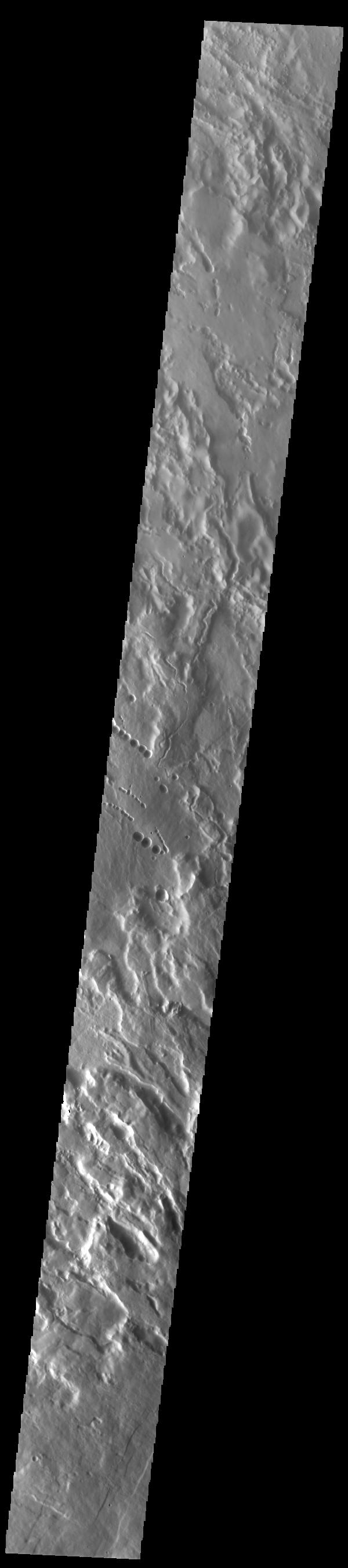
English: .png) Context image The three large aligned Tharsis volcanoes are Arsia Mons, Pavonis Mons and Ascreaus Mons (from south to north). There are collapse features on all three volcanoes, on the southwestern and northeastern flanks. This alignment may indicate a large fracture/vent system was responsible for the eruptions that formed all three volcanoes. This VIS image shows part of the northwestern flank of Arsia Mons, west of the aligned fracture system. The scalloped depressions and lines of craters are most likely created by collapse of the roof of lava tubes. Lava tubes originate during eruption event, when the margins of a flow harden around a still flowing lava stream. When an eruption ends these can become hollow tubes within the flow. With time, the roof of the tube may collapse into the empty space below. The tubes are linear, so the collapse of the roof creates a linear depression. In this region, the complexity of the collapse and faulting has created a unique surface. This region has collapse depressions with floors at a variety of elevations and depression sizes from small to large. Arsia Mons is the southernmost of the Tharsis volcanoes. It is 270 miles (450km) in diameter, almost 12 miles (20km) high, and the summit caldera is 72 miles (120km) wide. For comparison, the largest volcano on Earth is Mauna Loa. From its base on the sea floor, Mauna Loa measures only 6.3 miles high and 75 miles in diameter. A large volcanic crater known as a caldera is located at the summit of all of the Tharsis volcanoes. These calderas are produced by massive volcanic explosions and collapse. The Arsia Mons summit caldera is larger than many volcanoes on Earth. Orbit Number: 93113 Latitude: -6.63675 Longitude: 238.403 Instrument: VIS Captured: 2022-12-11 04:35 Please see the THEMIS Data Citation Note for details on crediting THEMIS images. NASA's Jet Propulsion Laboratory manages the 2001 Mars Odyssey mission for NASA's Science Mission Directorate, Washington, D.C. The Thermal Emission Imaging System (THEMIS) was developed by Arizona State University, Tempe, in collaboration with Raytheon Santa Barbara Remote Sensing. The THEMIS investigation is led by Dr. Philip Christensen at Arizona State University. Lockheed Martin Astronautics, Denver, is the prime contractor for the Odyssey project, and developed and built the orbiter. Mission operations are conducted jointly from Lockheed Martin and from JPL, a division of the California Institute of Technology in Pasadena. |
| Дата | (published) |
| Источник | Catalog page · Full-res (JPEG · TIFF) · Full-res ([ MP4]) · Full-res ([ GIF]) |
| Автор | NASA/JPL-Caltech/ASU |
| Другие версии |
|
Это изображение или видеозапись внесены в каталог Лаборатории реактивного движения НАСА под идентификатором (Photo ID): PIA25817. Этот шаблон не указывает на правовой статус данной работы. По-прежнему необходим нормальный шаблон лицензий. См. Commons:Лицензирование. Другие языки:
|
| This media is a product of the 2001 Mars Odyssey mission Credit and attribution belongs to the Thermal Emission Imaging System (THEMIS) team, NASA/JPL-Caltech/ASU |
Лицензирование

|
Владелец авторских прав на этот файл, NASA/JPL-Caltech, разрешает кому угодно использовать его в любых целях, при условии сохранения информации о владельце авторских прав. Разрешается распространение данного файла, создание производных произведений на его основе, а также коммерческое и любое другое использование. |
|
|
| According to JPL's image use policy additional restriction is that no endorsement of any product or service by Caltech, JPL or NASA is claimed or implied.
Caltech's disclaimer: Caltech makes no representations or warranties with respect to ownership of copyrights in the images, and does not represent others who may claim to be authors or owners of copyright of any of the images, and makes no warranties as to the quality of the images. Caltech shall not be responsible for any loss or expenses resulting from the use of the images, and you release and hold Caltech harmless from all liability arising from such use. Usage on the English Wikipedia: On the English Wikipedia you can use the {{JPL Image}} template to display the copyright notice. (See w:Wikipedia:Using JPL images for details) |
История файла
Нажмите на дату/время, чтобы посмотреть файл, который был загружен в тот момент.
| Дата/время | Миниатюра | Размеры | Участник | Примечание | |
|---|---|---|---|---|---|
| текущий | 13:42, 8 августа 2023 | 600 × 2705 (752 КБ) | OptimusPrimeBot | #Spacemedia - Upload of https://photojournal.jpl.nasa.gov/tiff/PIA25817.tif via Commons:Spacemedia |
Использование файла
Нет страниц, использующих этот файл.