Перейти на страницу файла на Викискладе

Файл:Bering Sea ESA376705.jpg

Материал из Википедии — свободной энциклопедии
Перейти к навигации Перейти к поиску

Исходный файл(3903 × 3955 пкс, размер файла: 9,89 МБ, MIME-тип: image/jpeg)

Краткое описание

Описание
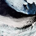
English: The Copernicus Sentinel-3A satellite brings us over the Bering Sea, north of the Alaska Peninsula, on 26 March.

Seasonal sea ice dominates the upper part of the image. Ice plays an important role in the sea’s ecosystem. Growing algae attach to the bottom of the ice; when the ice melts in the spring, it leaves behind a layer of nutrient-rich freshwater on which the algae thrive. Organisms higher up the food chain then eat the algae. In the top-right corner, we can see part of Alaska’s mainland blanketed with snow, as well as Nunivak Island appearing like a massive piece of floating ice. At the centre of the image are the islands of Saint Paul and Saint George – part of the Pribilof Islands. An estimated two million seabirds nest on these islands annually. The swirling clouds on the right side of the image are the result of a meteorological phenomenon known as a von Kármán vortex street. As wind-driven clouds pass over the Unimak Island on the right edge of the image, they flow around the high volcanoes to form the large spinning eddies that can clearly be seen in the image.

This image, also featured on the Earth from Space video programme, was captured by Sentinel-3’s Ocean and Land Colour Instrument, which helps monitor ocean ecosystems, supports crop management and agriculture, and provides estimates of atmospheric aerosol and clouds.
Дата
Источник http://www.esa.int/spaceinimages/Images/2017/04/Bering_Sea
Автор European Space Agency
Права
(Повторное использование этого файла)
contains modified Copernicus Sentinel data (2017), processed by ESA ,CC BY-SA 3.0 IGO
Другие версии
Title
InfoField
Bering Sea
System
InfoField
Copernicus
Keywords
InfoField
Sea-ice; Snow; Satellite image; Vortex; Weather systems
Set
InfoField
Earth observation image of the week
Mission
InfoField
Sentinel-3
Activity
InfoField
Observing the Earth

Лицензирование

w:ru:Creative Commons
атрибуция распространение на тех же условиях
Этот файл доступен по лицензии Creative Commons Attribution-Share Alike 3.0 IGO.
Вы можете свободно:
  • делиться произведением – копировать, распространять и передавать данное произведение
  • создавать производные – переделывать данное произведение
При соблюдении следующих условий:
  • атрибуция – Вы должны указать авторство, предоставить ссылку на лицензию и указать, внёс ли автор какие-либо изменения. Это можно сделать любым разумным способом, но не создавая впечатление, что лицензиат поддерживает вас или использование вами данного произведения.
  • распространение на тех же условиях – Если вы изменяете, преобразуете или создаёте иное произведение на основе данного, то обязаны использовать лицензию исходного произведения или лицензию, совместимую с исходной.

Краткие подписи

Добавьте однострочное описание того, что собой представляет этот файл

Элементы, изображённые на этом файле

изображённый объект

image/jpeg

10 373 538 байт

3955 пиксель

3903 пиксель

История файла

Нажмите на дату/время, чтобы посмотреть файл, который был загружен в тот момент.

Дата/времяМиниатюраРазмерыУчастникПримечание
текущий15:06, 12 мая 2017Миниатюра для версии от 15:06, 12 мая 20173903 × 3955 (9,89 МБ)YannHR from TIFF, 98% compression
12:36, 6 мая 2017Миниатюра для версии от 12:36, 6 мая 20171894 × 1920 (3,27 МБ)European Space Agency, Id 376705, http://www.esa.int/spaceinimages/Images/2017/04/Bering_Sea, User:Fæ/Project_list/ESA

Нет страниц, использующих этот файл.

Глобальное использование файла

Данный файл используется в следующих вики: