Файл:Bitterroot and Teton Ranges (MODIS 2023-12-25).jpg
Перейти к навигации
Перейти к поиску

Размер этого предпросмотра: 734 × 600 пкс. Другие разрешения: 294 × 240 пкс | 588 × 480 пкс | 940 × 768 пкс | 1253 × 1024 пкс | 2507 × 2048 пкс | 4049 × 3308 пкс.
Исходный файл (4049 × 3308 пкс, размер файла: 2,32 МБ, MIME-тип: image/jpeg)
Этот файл находится на Викискладе. Сведения о нём показаны ниже.
Викисклад — централизованное хранилище для свободных файлов, используемых в проектах Викимедиа.
|
.jpg?uselang=ru)
Краткое описание
| Описание |
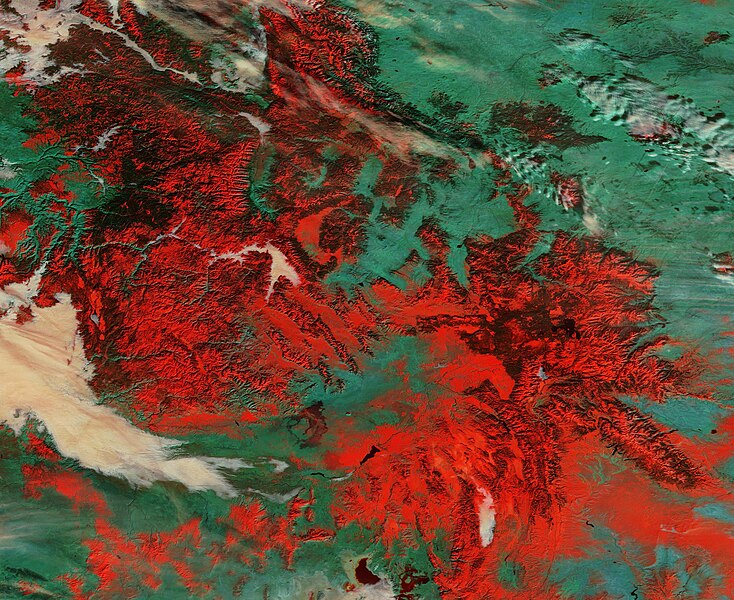
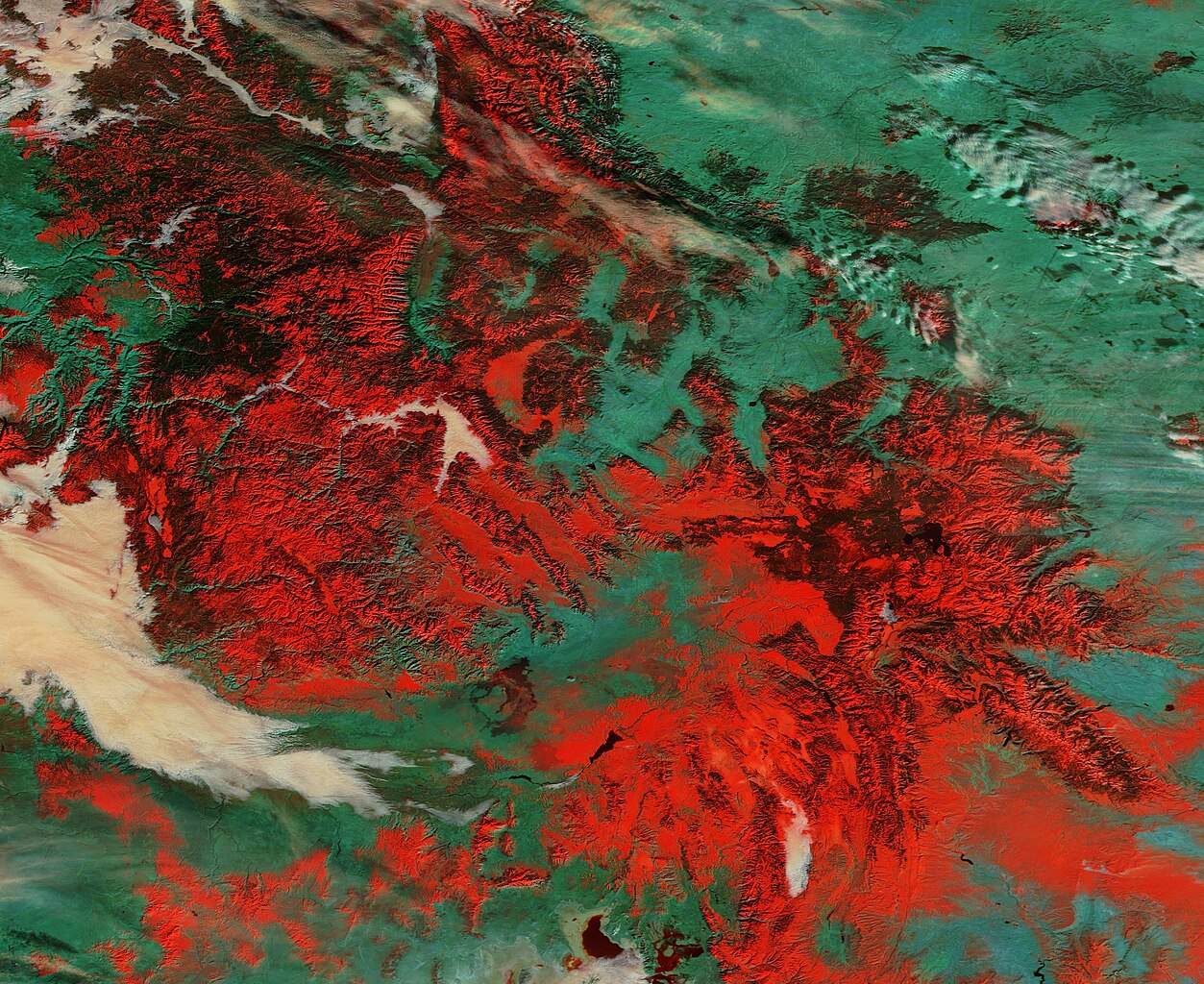
English: On December 17, 2023, the Moderate Resolution Imaging Spectroradiometer (MODIS) on NASA’s Terra satellite acquired a false-color image of snow atop the high ranges of the Bitterroot and Teton Ranges in the Western United States.
This type of image uses a combination of visible light and shortwave infrared (MODIS bands 3,6,7) to separate snow and ice (bright red) from vegetation (green). The thicker the snow or ice, the more light is absorbed, the more robust the red will appear. Cloud and fog (low cloud) looks white, except for very cold clouds that contain ice particles, which will take on a red tint. Both the Bitterroot Range and the Teton Mountains are subranges of the Rocky Mountains. The Tetons (in the southeast) stretch about 40 miles (64 km) in a north-south direction through the state of Wyoming and east of the border with Idaho. Most of the eastern section of the range lies within Grand Teton National Park. The Bitterroot Range sprawls across part of Idaho and Montana, spanning about 24,223 square miles (62,740 square kilometers). It takes its name from the state flower of Montana, a small, pink flower known as the bitterroot. |
||
| Дата | Снято: 17 декабря 2023 | ||
| Источник |
Bitterroot and Teton Ranges (direct link)
|
||
| Автор | MODIS Land Rapid Response Team, NASA GSFC |
| This media is a product of the Terra mission Credit and attribution belongs to the mission team, if not already specified in the "author" row |
Лицензирование
| Этот файл находится в общественном достоянии (англ. public domain), так как он был создан NASA (Национальным управлением по аэронавтике и исследованию космического пространства). Политика авторского права NASA гласит, что «Материал NASA не защищается авторским правом, если не указано иное». (См. Template:PD-USGov, страницу политики авторского права NASA или политику использования изображений JPL.) | ||
 |
Предупреждения:
|
История файла
Нажмите на дату/время, чтобы посмотреть файл, который был загружен в тот момент.
| Дата/время | Миниатюра | Размеры | Участник | Примечание | |
|---|---|---|---|---|---|
| текущий | 05:05, 26 декабря 2023 | | 4049 × 3308 (2,32 МБ) | OptimusPrimeBot | #Spacemedia - Upload of http://modis.gsfc.nasa.gov/gallery/images/image12252023_250m.jpg via Commons:Spacemedia |
Использование файла
Нет страниц, использующих этот файл.
.jpg)