Файл:Carrizo Chuska NASA.jpg

Исходный файл (1850 × 1255 пкс, размер файла: 606 КБ, MIME-тип: image/jpeg)
Этот файл находится на Викискладе. Сведения о нём показаны ниже.
Викисклад — централизованное хранилище для свободных файлов, используемых в проектах Викимедиа.
|
Краткое описание
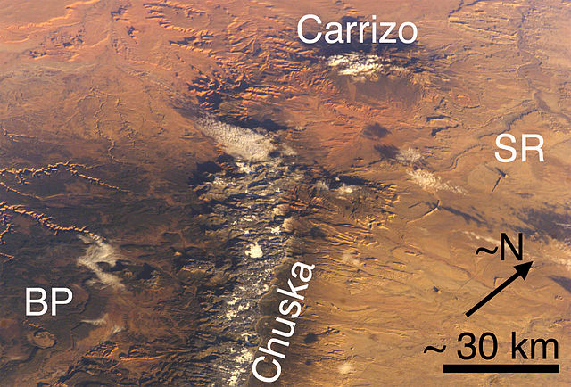
(view due-northwest-note N-arrow)-Carrizo Mountains (Arizona) and Chuska Mountains (Arizona and New Mexico), each with a little snow. Also, two features of the Navajo Volcanic Province: BP Buell Peak, (Arizona)-(at southeast perimeter, Canyon de Chelly), and SR Ship Rock (New Mexico). Cropped, marked, and lower resolution from http://eol.jsc.nasa.gov/ NASA image ISS008-E-5589.
Also, Red Rock Valley is between the two mountain ranges (and is reddish-Ship Rock to the east); in the same alignment with the Chuska trendline-(but north of Carrizos), is Walker Creek-(northeast tributary of Chinle Creek), and Alcove Canyon, both connected to the west & southwest of the Carrizo Mtns; west of the Chuskas is also Canyon de Chelly-(showing eastern canyons/rivercourses); southwest is the Defiance Plateau (Canyon de Chelly at its north terminus-Buell Peak, adjacent southeast, on Defiance Plateau);
Walker Creek is part of the northeast of Chinle Valley.
Note Cloud Shadows; the mountains, or canyons are also making shadows, i.e. an early morning photo, sun in East, or ESEast-(?).
Лицензирование
| Этот файл находится в общественном достоянии (англ. public domain), так как он был создан NASA (Национальным управлением по аэронавтике и исследованию космического пространства). Политика авторского права NASA гласит, что «Материал NASA не защищается авторским правом, если не указано иное». (См. Template:PD-USGov, страницу политики авторского права NASA или политику использования изображений JPL.) | ||
 |
Предупреждения:
|
История файла
Нажмите на дату/время, чтобы посмотреть файл, который был загружен в тот момент.
| Дата/время | Миниатюра | Размеры | Участник | Примечание | |
|---|---|---|---|---|---|
| текущий | 19:33, 27 июня 2006 | | 1850 × 1255 (606 КБ) | Omphacite~commonswiki | Carrizo Mountains (Arizona) and Chuska Mountains (Arizona and New Mexico), each with a little snow. Also, two features of the Navajo Volcanic Province: BP Buell Park (Arizona), and SR Ship Rock (New Mexico). Cropped, marked, and lower resolution from http |
Использование файла
Нет страниц, использующих этот файл.
Глобальное использование файла
Данный файл используется в следующих вики:
- Использование в en.wikipedia.org
- Использование в es.wikipedia.org