Файл:Comparison of the rectified channel of the Rio Grande with a previous natural channel.svg
Перейти к навигации
Перейти к поиску

Размер этого PNG-превью для исходного SVG-файла: 671 × 600 пкс. Другие разрешения: 268 × 240 пкс | 537 × 480 пкс | 859 × 768 пкс | 1145 × 1024 пкс | 2291 × 2048 пкс.
Исходный файл (SVG-файл, номинально 859 × 768 пкс, размер файла: 397 КБ)
Этот файл находится на Викискладе. Сведения о нём показаны ниже.
Викисклад — централизованное хранилище для свободных файлов, используемых в проектах Викимедиа.
|
Краткое описание
| Описание |
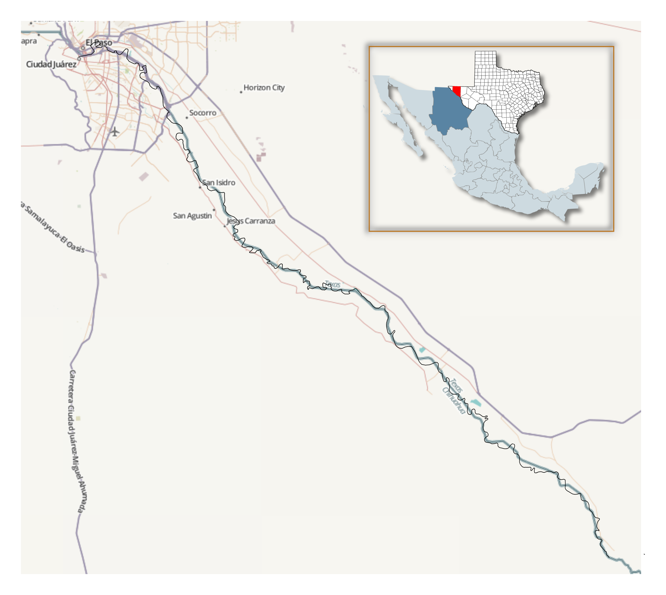
English: For the purposes of comparison, I overlaid an OpenStreetMap.org map of the U.S.-Mexico border in the El Paso-Juarez Valley (over the entire distance of the 1935-1938 Rio Grande Rectification from El Paso to Little Box Canyon, south of Fort Quitman). I created an overlay with an Inkscape tracing of the border as it existed well prior to the rectification. I obtained the tracing of the old border from 1908, 1907 and 1894 USGS maps that are available at the "USGS Store" website. In this SVG file, the current border from OpenStreetMap (aquamarine color) is overlaid on its northern half with the border from the 1908 and 1907 maps (black color) and on its southern half with the border being the river as shown in the 1894 map (black color). Note that in the 1908 map of the El Paso Quadrangle, there are several places where the border does not coincide with the then-current course of the Rio Grande, including a significant cut-off area that is too large for the Banco Convention of 1905 to apply. Use suggested at Territorial evolution of the United States |
| Дата | |
| Источник |
http://www.openstreetmap.org and USGS quadrant maps (available at the USGS Store Map Locator & Downloader, http://store.usgs.gov/b2c_usgs/usgs/maplocator/(xcm=r3standardpitrex_prd&layout=6_1_61_48&uiarea=2&ctype=catalogEntry&carea=%24ROOT)/.do ):El Paso Quadrangle, Texas, 1:125000, edition of Jan 1908 (surveyed in 1891, 1905 and 1907), reprinted 1921, U.S. Geological Survey, Washington, DC (TX_El Paso_123949_1908_125000_geo.pdf) Rio Grande Sheet, Texas, 1:125000, edition of Nov 1896 (surveyed in 1891), corrected Jan 1907 from 1905 Reclamation Service Surveys, reprinted 1911, U.S. Geological Survey, Washington, DC (TX_Rio Grande_128616_1896_125000_geo.pdf) Fort Hancock Sheet, Texas, 1:125000, edition of Jan 1894 (surveyed in 1891), reprinted 1928, U.S. Geological Survey, Washington, DC (TX_Fort Hancock_123983_1894_125000_geo.pdf) |
| Автор | OpenStreetMap contributors and Jeff in CA |
| Права (Повторное использование этого файла) |
The data is available under the Open Database License, and the cartography is licensed as CC BY-SA. See http://www.openstreetmap.org/copyright |
- Other information
English: Credit: © OpenStreetMap contributors. The data is available under the Open Database License, and the cartography is licensed as CC BY-SA. Further information: see copyright page.
Creative Commons Attribution-ShareAlike 2.0
Лицензирование

|
Владелец авторских прав на этот файл разрешает всем использовать его в любых целях, при условии сохранения информации о владельце авторских прав. Разрешается распространение данного файла, создание производных произведений на его основе, а также коммерческое и любое другое использование. |
|
|
История файла
Нажмите на дату/время, чтобы посмотреть файл, который был загружен в тот момент.
| Дата/время | Миниатюра | Размеры | Участник | Примечание | |
|---|---|---|---|---|---|
| текущий | 02:02, 22 апреля 2016 | | 859 × 768 (397 КБ) | Jeff in CA | Reverted to version as of 01:36, 22 April 2016 (UTC) |
| 02:01, 22 апреля 2016 |  | 859 × 768 (397 КБ) | Jeff in CA | added inset to show location | |
| 01:36, 22 апреля 2016 |  | 859 × 768 (397 КБ) | Jeff in CA | Reverted to version as of 01:32, 22 April 2016 (UTC) | |
| 01:36, 22 апреля 2016 |  | 859 × 768 (167 КБ) | Jeff in CA | Reverted to version as of 01:31, 22 April 2016 (UTC) | |
| 01:32, 22 апреля 2016 |  | 859 × 768 (397 КБ) | Jeff in CA | added inset to show location | |
| 01:31, 22 апреля 2016 |  | 859 × 768 (167 КБ) | Jeff in CA | Reverted to version as of 22:19, 8 April 2016 (UTC) | |
| 01:30, 22 апреля 2016 |  | 859 × 768 (397 КБ) | Jeff in CA | added inset to show location | |
| 22:19, 8 апреля 2016 |  | 859 × 768 (167 КБ) | Jeff in CA | {{subst:Upload marker added by en.wp UW}} {{Information |Description = {{en|For the purposes of comparison, I overlaid an OpenStreetMap.org map (captured 7 April 2016) of the U.S.-Mexico border in the El Paso-Juarez Valley (over the entire distance of... |
Использование файла
Нет страниц, использующих этот файл.
Глобальное использование файла
Данный файл используется в следующих вики:
- Использование в en.wikipedia.org