Файл:Cosmographia. - Norman B. Leventhal Map Center at the BPL.jpg
Перейти к навигации
Перейти к поиску

Размер этого предпросмотра: 800 × 562 пкс. Другие разрешения: 320 × 225 пкс | 640 × 450 пкс | 1024 × 719 пкс | 1200 × 843 пкс.
Исходный файл (1200 × 843 пкс, размер файла: 478 КБ, MIME-тип: image/jpeg)
Этот файл находится на Викискладе. Сведения о нём показаны ниже.
Викисклад — централизованное хранилище для свободных файлов, используемых в проектах Викимедиа.
|
Краткое описание
| Автор |
Lord Nicolas the German (Donnus Nicholas Germanus), cartographer Johann the Blockcutter of Armsheim (Johannes Schnitzer or Johannes de Armsheim), engraver |
| Автор | |
| Описание |
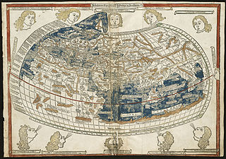
English: The world map from a 1482 edition of Nicolaus Germanus's emendations to Jacobus Angelus's 1406 Latin translation of Maximus Planudes's late-13th century rediscovered Greek manuscripts of Ptolemy's 2nd-century Geography.
BPL Call Number: G1005 .P7 1482 View at the Norman B. Leventhal Map Center Zoom into this map at maps.bpl.org. The classical Greek and Roman world view is known to us through the writings of Claudius Ptolemy, a 2nd century A.D. astronomer, mathematician, and geographer who lived in Alexandria, Egypt. Although his original manuscript no longer exists, various copies survived through the Middle Ages. With the advent of the printing press in the late-15th century, it was one the first geographical texts printed. The first printed editions of Geographia included a world map and 26 regional maps. These maps depicted the extent of the world as known to the ancient Greeks and Romans, which focused on the lands bordering the Mediterranean-- Europe, northern Africa, and western and southern Asia. Despite the disclosure of New World discoveries, such maps still had a strong influence on the Europeans' geographical concept of the world. Unfortunately for the early explorers, this world image underestimated the Earth's circumference and overestimated the breadth of the Eurasian land mass. While the first printed edition of Geographia that included maps was published in Bologna in 1477, the Ulm edition was the first printed north of the Alps and the first to include wood cut printed maps. New and updated versions of Geographia were printed until the mid-19th century. |
| Дата | 16 июля 1482 |
| Источник/Фотограф | Norman Bleventhal Map Center on Flickr. |
| Другие версии |
|


Лицензирование
Этот файл доступен по лицензии Creative Commons Attribution 2.0 Generic
- Вы можете свободно:
- делиться произведением – копировать, распространять и передавать данное произведение
- создавать производные – переделывать данное произведение
- При соблюдении следующих условий:
- атрибуция – Вы должны указать авторство, предоставить ссылку на лицензию и указать, внёс ли автор какие-либо изменения. Это можно сделать любым разумным способом, но не создавая впечатление, что лицензиат поддерживает вас или использование вами данного произведения.
| Это изображение изначально опубликовано на Flickr участником проекта Norman B. Leventhal Map Center at the BPL по ссылке https://www.flickr.com/photos/24528911@N05/2709976847. Оно было досмотрено 2 июля 2012 роботом FlickreviewR, который подтвердил, что изображение лицензировано в соответствии с условиями cc-by-2.0. |
История файла
Нажмите на дату/время, чтобы посмотреть файл, который был загружен в тот момент.
| Дата/время | Миниатюра | Размеры | Участник | Примечание | |
|---|---|---|---|---|---|
| текущий | 01:43, 2 июля 2012 | | 1200 × 843 (478 КБ) | Dzlinker | == {{int:filedesc}} == {{Information |Description=Zoom into [http://maps.bpl.org/id/M10001/ this map] at [http://maps.bpl.org maps.bpl.org]. '''Author:''' Ptolemy '''Publisher:''' Lienhart Holle '''Date:''' 16 July 1482. '''Call Number:''' G1005.1482... |
Использование файла
Нет страниц, использующих этот файл.
Глобальное использование файла
Данный файл используется в следующих вики:
- Использование в en.wikipedia.org