Файл:Custer Battlefield in the Crow Reservation, MT, established May 7, 1868.png
Перейти к навигации
Перейти к поиску

Размер этого предпросмотра: 800 × 439 пкс. Другие разрешения: 320 × 176 пкс | 640 × 351 пкс | 1024 × 562 пкс | 1280 × 702 пкс | 2560 × 1405 пкс | 3864 × 2120 пкс.
Исходный файл (3864 × 2120 пкс, размер файла: 15,47 МБ, MIME-тип: image/png)
Этот файл находится на Викискладе. Сведения о нём показаны ниже.
Викисклад — централизованное хранилище для свободных файлов, используемых в проектах Викимедиа.
|
Краткое описание
| Описание |
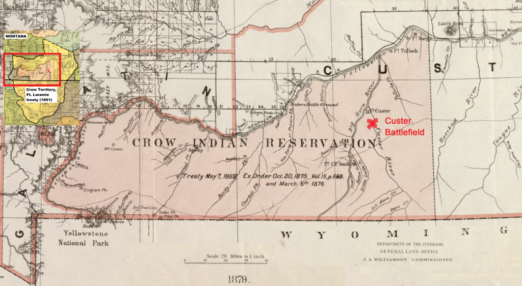
Dansk: Kortet viser Custer Battlefield ved Little Bighorn River (1876) i crow reservatet i Montana. Reservatet blev oprettet den 7. maj 1868 i hjertet af crowernes territorium som fastlagt i Fort Laramie traktaten (1851) (se det lille indsatte kort) og også anerkendt som sådan af lakotaerne.
English: The map shows the Custer Battlefield at the Little Bighorn River (1876) in the Crow Reservation, Montana, established on May 7, 1868. The reservation was located in the heart of the Crow territory as acknowledged by the Lakotas with the signing of the Fort Laramie treaty (1851) – see the little map in the upper, left corner. |
| Дата | |
| Источник | www.loc.gov/resource/g4250.cws00190 (Detail of a 1879 map of Montana Territory and adapted to show the Custer Battlefield at the Little Bighorn River in the Crow Reservation) |
| Автор | Roeser, Charles |
Лицензирование
Это произведение находится в общественном достоянии (англ. public domain) в США, так как оно было опубликовано до 1 января 1929 года.
Чтобы быть размещёнными на Викискладе, произведения в общественном достоянии не должны быть защищены авторским правом одновременно и в США, и в стране-источнике данного произведения. Если произведение опубликовано не в США, файл должен иметь дополнительный шаблон лицензии, показывающий его статус в стране-источнике с точки зрения охраны авторских прав.
|

|
This is a file uploaded through the Danish Wikipedia, which has not been reviewed on Commons:
|
История файла
Нажмите на дату/время, чтобы посмотреть файл, который был загружен в тот момент.
| Дата/время | Миниатюра | Размеры | Участник | Примечание | |
|---|---|---|---|---|---|
| текущий | 08:58, 18 сентября 2022 | | 3864 × 2120 (15,47 МБ) | Indianertosset | Uploaded a work by Roeser, Charles from www.loc.gov/resource/g4250.cws00190 (Detail of a 1879 map of Montana Territory and adapted to show the Custer Battlefield at the Little Bighorn River in the Crow Reservation) with UploadWizard |
Использование файла
Нет страниц, использующих этот файл.
Глобальное использование файла
Данный файл используется в следующих вики:
- Использование в da.wikipedia.org