Файл:EB9 United States - historical maps (bottom).jpg
Перейти к навигации
Перейти к поиску
Размер этого предпросмотра: 750 × 600 пкс. Другие разрешения: 300 × 240 пкс | 600 × 480 пкс | 961 × 768 пкс | 1280 × 1024 пкс | 2501 × 2000 пкс.
Исходный файл (2501 × 2000 пкс, размер файла: 942 КБ, MIME-тип: image/jpeg)
Этот файл находится на Викискладе. Сведения о нём показаны ниже.
Викисклад — централизованное хранилище для свободных файлов, используемых в проектах Викимедиа.
|
Краткое описание
| Описание |
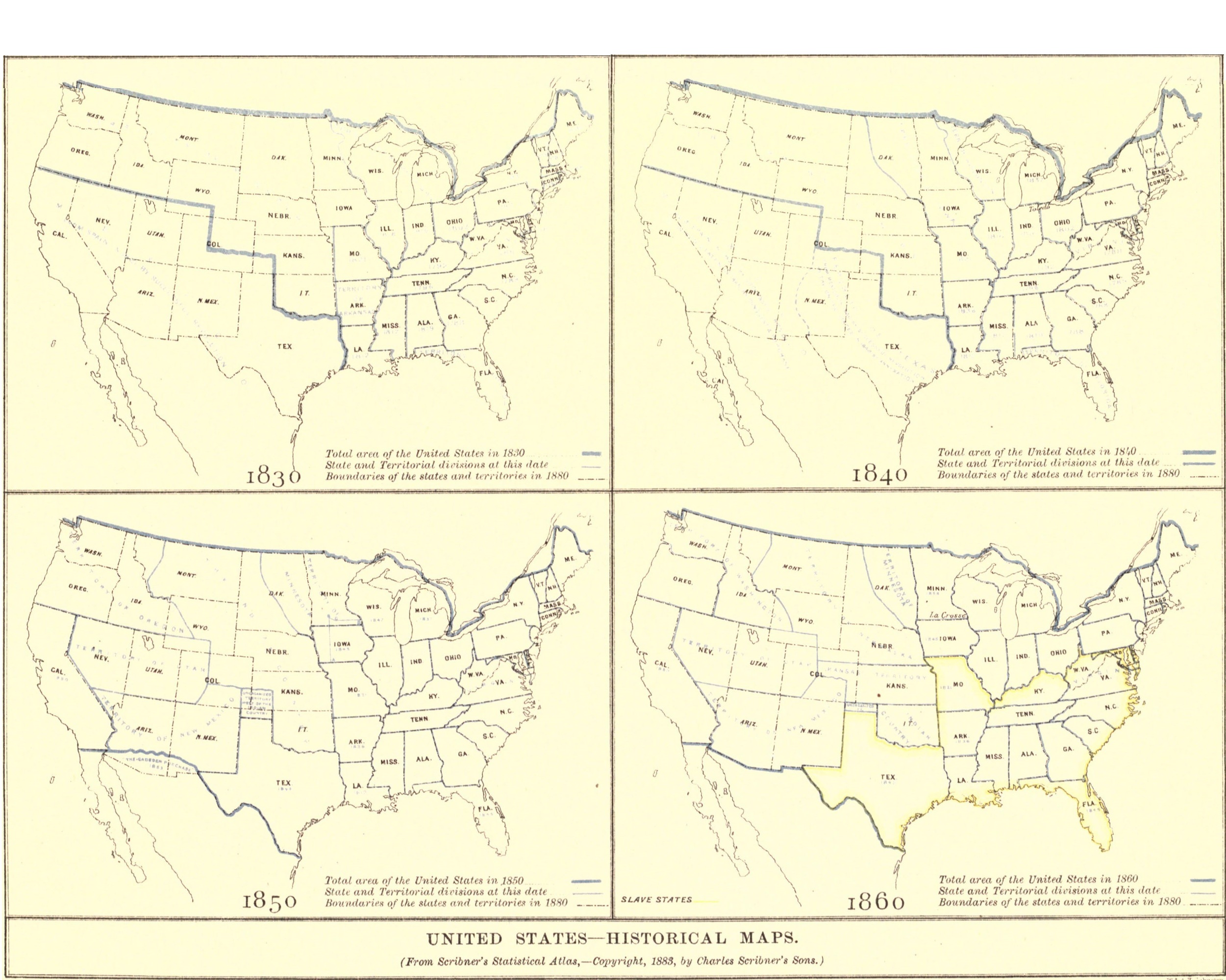
English: 4 historical maps of the United States, the bottom half of Plate VII. in the article "United States" in the American version of the Encyclopaedia Britannica, 9th ed. 1830, depicting the dates of states' admissions to the United States, the Arkansas Territory, and various other changes in the 1810s and 1820s with illegible blue text. Total area of the United States in 1830 depicted with a thick blue line, State and Territorial divisions at this date depicted with thin blue lines, & Boundaries of the states and territories in 1880 depicted with a black dot-and-dash line. 1840, depicting the dates of states' admissions to the United States, the Iowa Territory, the Republic of Texas, and various other changes in the 1810s with illegible blue text. Total area of the United States in 1840 depicted with a thick blue line, State and Territorial divisions at this date depicted with thin blue lines, & Boundaries of the states and territories in 1880 depicted with a black dot-and-dash line. 1850, depicting the dates of states' admissions to the United States, the Minnesota, Oregon, Utah, and New Mexico Territories, the Unorganized Territory west of the Indian Country, the Gadsden Purchase, and various other changes in the 1840s with illegible blue text. Total area of the United States in 1850 depicted with a thick blue line, State and Territorial divisions at this date depicted with thin blue lines, & Boundaries of the states and territories in 1880 depicted with a black dot-and-dash line. 1860, depicting the dates of states' admissions to the United States, the Washington, Nebraska, Utah, New Mexico, Kansas, and Minnesota Territories, Indian Country, and various other changes in the 1850s with illegible blue text. slave states [yellow]. Total area of the United States in 1860 depicted with a thick blue line, State and Territorial divisions at this date depicted with thin blue lines, & Boundaries of the states and territories in 1880 depicted with a black dot-and-dash line. La Crosse inexplicibly marked in Minnesota. |
|||
| Дата | ||||
| Источник | “United States” in the Encyclopædia Britannica, 9th ed., Vol. XXIII, Plate VII. (bottom), between pp. 728 and 729. | |||
| Автор | Анонимный автор, from an original in Scribner's Historical Atlas, published by Charles Scribner's Sons, engraved by William & Alexander Keith Johnston | |||
| Права (Повторное использование этого файла) |
|
|||
| Другие версии |
|

.jpg)
.jpg?uselang=ru)
История файла
Нажмите на дату/время, чтобы посмотреть файл, который был загружен в тот момент.
| Дата/время | Миниатюра | Размеры | Участник | Примечание | |
|---|---|---|---|---|---|
| текущий | 21:51, 20 августа 2018 | | 2501 × 2000 (942 КБ) | Bob Burkhardt | {{Information |description ={{en|1=Historical maps of the United States for 1830, 1840, 1850, 1860.}} |date =1888 |source =“United States,” ''Encyclopædia Britannica'' (9th ed.), v. 23, 1888, Plate VII. (bottom), between pp. 728 and 729. |author =Charles Scribner's Sons (''Scribner's Historical Atlas'') |permission ={{PD-Britannica}} }} Category:Old maps of the United States |
Использование файла
Нет страниц, использующих этот файл.
Глобальное использование файла
Данный файл используется в следующих вики:
- Использование в en.wikisource.org
.jpg)