Файл:EFS highres STS091 STS091-731-32.JPG

Исходный файл (4078 × 4078 пкс, размер файла: 15,84 МБ, MIME-тип: image/jpeg)
Этот файл находится на Викискладе. Сведения о нём показаны ниже.
Викисклад — централизованное хранилище для свободных файлов, используемых в проектах Викимедиа.
|
Краткое описание
| Описание |
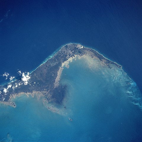
English: STS091-731-032 Grand Bahama Island, Freeport and Lucaya, Bahamas June 1998
The small cities of Freeport and Lucaya, on the southwest portion of Grand Bahama Island (slightly above the center of the view), can be seen in this southwest-looking view. Freeport and Lucaya are the Bahamas second largest metropolitan area. Nearly 50 years ago, neither city even existed. The Freeport and Lucaya region is a free trade zone area. Besides numerous tourist resorts and recreational areas, Freeport and Lucaya’s other activities include oil refining, cement production, distilling of liquor, and making of pharmaceutical products. As with the other islands of the Bahamas, Grand Bahama is composed largely of calcareous materials derived from marine organisms. A karst landscape covers many of the higher elevations on the island. Grand Bahama Island is 96 miles (154 km) long and 17 miles (27 km) at its widest point. The darker blue, deep waters of the Atlantic Ocean are visible in the upper portion of the view. The lighter blue, shallow waters covering the Bahama Shelf are discernible in the bottom portion of the view. Images: All Available Images Low-Resolution 277k Mission: STS091 Roll - Frame: 731 - 32 Geographical Name: BAHAMAS Features: FREEPORT, GRAND BAHAMA I. Center Lat x Lon: 26.5N x 78.5W Film Exposure: N N=Normal exposure, U=Under exposed, O=Over exposed, F=out of Focus Percentage of Cloud Cover-CLDP: 5 Camera: HB Camera Tilt: 16 LO=Low Oblique, HO=High Oblique, NV=Near Vertical Camera Focal Length: 250 Nadir to Photo Center Direction: NW The direction from the nadir to the center point, N=North, S=South, E=East, W=West Stereo?: Y Y=Yes there is an adjacent picture of the same area, N=No there isn't Orbit Number: 78 Date: 19980607 YYYYMMDD Time: 195254 GMT HHMMSS Nadir Lat: 25.8N Latitude of suborbital point of spacecraft Nadir Lon: 77.9W Longitude of suborbital point of spacecraft Sun Azimuth: 274 Clockwise angle in degrees from north to the sun measured at the nadir point Space Craft Altitude: 198 nautical miles Sun Elevation: 53 Angle in degrees between the horizon and the sun, measured at the nadir point Land Views: ISLAND, COAST Water Views: OCEAN Atmosphere Views: Man Made Views: URBAN AREA, AIRPORT City Views: FREEPORT |
| Дата | |
| Источник |
http://eol.jsc.nasa.gov/sseop/EFS/photoinfo.pl?PHOTO=STS091-731-32 http://eol.jsc.nasa.gov/scripts/sseop/LargeImageAccess.pl?directory=EFS/highres/STS091&filename=STS091-731-32.JPG&filesize=16606733 |
| Автор | Image Science and Analysis Laboratory, NASA-Johnson Space Center |
Это изображение или видеозапись внесены в каталог одного из исследовательских центров НАСА под идентификатором (Photo ID): STS091-731-32. Этот шаблон не указывает на правовой статус данной работы. По-прежнему необходим нормальный шаблон лицензий. См. Commons:Лицензирование. Другие языки:
|
Лицензирование
| Этот файл находится в общественном достоянии (англ. public domain), так как он был создан NASA (Национальным управлением по аэронавтике и исследованию космического пространства). Политика авторского права NASA гласит, что «Материал NASA не защищается авторским правом, если не указано иное». (См. Template:PD-USGov, страницу политики авторского права NASA или политику использования изображений JPL.) | ||
 |
Предупреждения:
|
История файла
Нажмите на дату/время, чтобы посмотреть файл, который был загружен в тот момент.
| Дата/время | Миниатюра | Размеры | Участник | Примечание | |
|---|---|---|---|---|---|
| текущий | 08:26, 14 апреля 2011 | | 4078 × 4078 (15,84 МБ) | Andkore | {{Information |Description ={{en|1=STS091-731-032 Grand Bahama Island, Freeport and Lucaya, Bahamas June 1998 The small cities of Freeport and Lucaya, on the southwest portion of Grand Bahama Island (slightly above the center of the view), can be seen |
Использование файла
Нет страниц, использующих этот файл.
Глобальное использование файла
Данный файл используется в следующих вики:
- Использование в el.wikipedia.org
- Использование в en.wikipedia.org
- Использование в es.wikipedia.org
- Использование в eu.wikipedia.org
- Использование в fa.wikipedia.org
- Использование в fo.wikipedia.org
- Использование в fr.wikipedia.org
- Использование в ja.wikipedia.org
- Использование в ka.wikipedia.org
- Использование в nl.wikipedia.org
- Использование в pt.wikipedia.org
- Использование в sr.wikipedia.org
- Использование в tr.wikipedia.org
- Использование в zh.wikipedia.org