Файл:Fires across the Southeastern United States (MODIS 2022-02-17).jpg
Исходный файл (3138 × 2409 пкс, размер файла: 794 КБ, MIME-тип: image/jpeg)
Этот файл находится на Викискладе. Сведения о нём показаны ниже.
Викисклад — централизованное хранилище для свободных файлов, используемых в проектах Викимедиа.
|
.jpg?uselang=ru)
Краткое описание
| Описание |
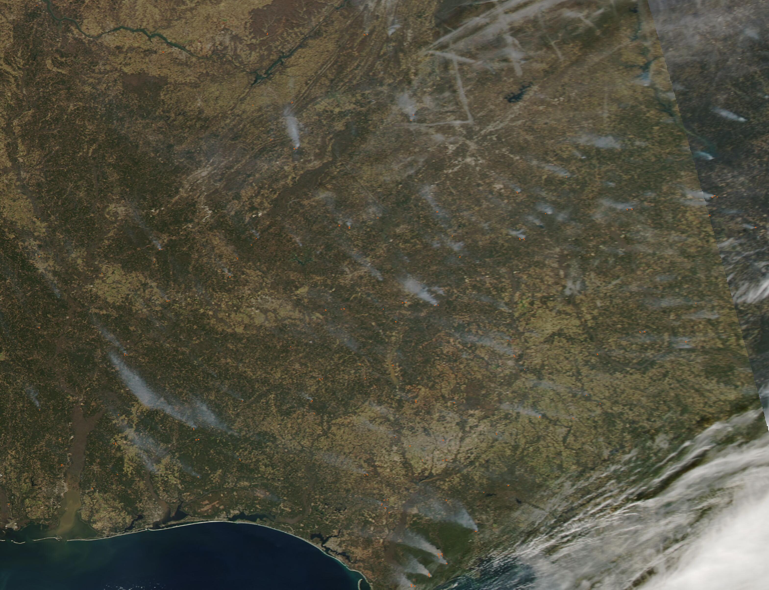
English: Dozens of fires were scattered over the Southeastern United States on February 15, 2022, when the Moderate Resolution Imaging Spectroradiometer (MODIS) on board NASA’s Aqua satellite acquired a true-color image of the region. Each red “hot spot” marks an area where the thermal sensors on the MODIS instrument detected high temperatures. When combined with typical smoke, as in this image, such hot spots mark actively burning fire. The blazes are scattered across Alabama (west), Georgia (east), and Florida.
The widespread nature, location, and time of year suggests that most of these fires are likely prescribed burns—fires that are deliberately set to manage public lands, such as forests or grassland. Such controlled burns are carefully planned to benefit the environment and wildlife, and also helps reduce the impact of wildfires by reducing fuel ahead of wildfire season. Winter’s weather, with cooler temperatures, is prime time for prescribed burns in this region. In late January, the U.S. Forest Service announced that, in Alabama, approximately 120,000 acres in four national forests in that state were slated for prescribed fires before the end of winter. Similar land management is occurring in Georgia and Florida as well. It is also possible that some of these fires are agricultural in nature. Agricultural fires are similar to prescribed burns in that they are deliberately set to manage land, but they are typically set by farmers to freshen pasture or work cropland. According to reports from the National Interagency Fire Center from February 11, only one wildfire was burning in this region on that date. That fire was near Elgin Air Force Base, had been contained, and affected about 460 acres. Elgin sits close to the coast on the Florida Panhandle. |
||
| Дата | Снято: 15 февраля 2022 | ||
| Источник |
Fires across the Southeastern United States (direct link)
|
||
| Автор | MODIS Land Rapid Response Team, NASA GSFC |
| This media is a product of the Aqua mission Credit and attribution belongs to the mission team, if not already specified in the "author" row |
Лицензирование
| Этот файл находится в общественном достоянии (англ. public domain), так как он был создан NASA (Национальным управлением по аэронавтике и исследованию космического пространства). Политика авторского права NASA гласит, что «Материал NASA не защищается авторским правом, если не указано иное». (См. Template:PD-USGov, страницу политики авторского права NASA или политику использования изображений JPL.) | ||
 |
Предупреждения:
|
История файла
Нажмите на дату/время, чтобы посмотреть файл, который был загружен в тот момент.
| Дата/время | Миниатюра | Размеры | Участник | Примечание | |
|---|---|---|---|---|---|
| текущий | 22:16, 9 января 2024 | | 3138 × 2409 (794 КБ) | OptimusPrimeBot | #Spacemedia - Upload of http://modis.gsfc.nasa.gov/gallery/images/image02172022_250m.jpg via Commons:Spacemedia |
Использование файла
Нет страниц, использующих этот файл.
.jpg)