Файл:Flickr - law keven - Days End.....jpg

Исходный файл (3888 × 2592 пкс, размер файла: 675 КБ, MIME-тип: image/jpeg)
Этот файл находится на Викискладе. Сведения о нём показаны ниже.
Викисклад — централизованное хранилище для свободных файлов, используемых в проектах Викимедиа.
|
Краткое описание
| Описание |
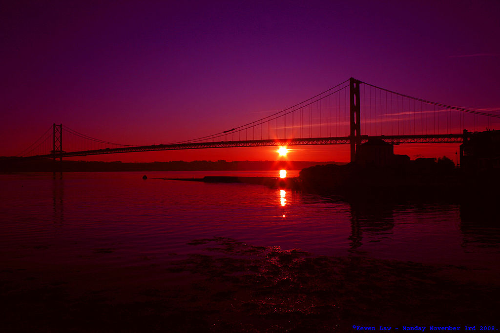
Highest Explore Position #253 ~ On November 11th 2008. Sunset - Forth Road Bridge - Edinburgh, Scotland - Monday November 3rd 2008. Click here to see the Larger image Click here to see My most interesting images The Forth Road Bridge is a suspension bridge in east central Scotland. The bridge, built in 1964, spans the Firth of Forth, connecting the capital city Edinburgh at South Queensferry to Fife at North Queensferry. The bridge replaced a centuries-old ferry service to carry vehicular traffic, cyclists, and pedestrians across the Forth; rail crossings are made by the adjacent and historic Forth Bridge. Issues regarding the continued tolling of the bridge, and those over its deteriorating condition and proposals to have it replaced or supplemented by an additional crossing, have caused it to become something of a political football for the Scottish Parliament, which eventually voted to scrap tolls on the bridge with effect from 11 February 2008. History ~ The first crossing at what is now the site of the bridge was established in the 11th century by Margaret, queen consort of King Malcolm III, who founded a ferry service to transport religious pilgrims from Edinburgh to Dunfermline Abbey and St Andrews.[1] Its creation gave rise to the port towns which remain to this day, and the service remained in uninterrupted use as a passenger ferry for over eight hundred years. As early as the 1740s there were proposals for a road crossing at the site, although their viability was only considered following the construction of the first Forth bridge in 1890. The importance of the crossing to vehicular traffic was underpinned when the Great Britain road numbering scheme was drawn up in the 1920s. The planners wished the arterial A9 road to be routed across the Forth here, although the unwillingness to have a ferry crossing as part of this route led to the A90 number being assigned instead. There was a period of renewed lobbying for a road crossing in the 1920s and 1930s, at which time the only vehicle crossing was a single passenger and vehicle ferry. Sir William Denny championed the expansion of that service in the 1930s, providing and operating two additional ferries on behalf of the London and North Eastern Railway that aimed to supplement the services of the adjacent railway bridge. Their success allowed for the addition of two more craft in the 1940s and 1950s, by which time the ferries were making 40,000 crossings, carrying 1.5 million passengers and 800,000 vehicles annually. With the then-newest and nearest bridge spanning the Forth (the Kincardine Bridge, built in 1936) still around 15 miles (24 km) upstream, the upsurge in demand for a road crossing between Edinburgh and Fife prompted the UK government to establish the Forth Road Bridge Joint Board by Act of Parliament in 1947 to oversee the implementation of a new bridge to replace the ferry service. The final construction plan was accepted in February 1958 and work began in September of that year. Mott, Hay and Anderson and Freeman Fox & Partners carried out the design work and Sir William Arrol & Co. constructed the bridge at a cost of £11.5 million, while the total cost of the project including road connections and realignments was £19.5 million. Seven lives were lost during construction before the bridge was opened by Queen Elizabeth II and the Duke of Edinburgh on 4 September 1964.[6] The ferry service was discontinued as of that date. The bridge's management was delegated to the FRBJB, and remained so until 2002 when its operation was transferred to a new body with a wider remit, the Forth Estuary Transport Authority. Statistics ~ The bridge's central main span is 1,006 m (3,298 ft) long, its two side spans are each 408 m (1338 ft) long, and the approach viaducts are 252 m (827 ft) on the north side and 438 m (1,437 ft) on the south side; at a total length of 2,512 m (8,242 ft), it was the longest suspension bridge outside the United States and the fourth-largest in the world at the time of its construction. The bridge comprises 39,000 tons of steel and 115,000 cubic metres of concrete. Its width comprises a dual carriageway road with two lanes in each direction bounded by cycle/footpaths on each side. The main strung cables are 590 mm in diameter and each carries 13,800 tonnes of the bridge's load by suspending 11,618 5 mm diameter high tensile wires. The bridge forms a crucial part of the corridor between south-east and north-east Scotland, linking Edinburgh to Perth, Dundee and Aberdeen by the A90 road and its sister M90 motorway which begins a few miles north of the bridge's northern terminus. The bridge carried around 2.5 million vehicles in its first year but the annual figure has risen steadily over time to around 11.8 million vehicles in 2004 alone. The bridge carried its 250 millionth vehicle in 2002. It was awarded Historic Scotland's Category A listed structure status in 2001. Tolling issues ~ On 11 February 2008 tolls were abolished on the bridge. Initially, it was suggested that tolling would cease once the original cost of construction plus interest accrued had been repaid - this was done in 1993 and tolls were planned for removal by May 1995. However, the legislation enabling the levying of tolls has instead been renewed by Parliament (originally that of the UK but now the responsibility of the Scottish Parliament) on three separate occasions in 1998, 2003 and 2006. Originally, a toll was paid for each direction of travel with sets of toll booths on both carriageways. In 1997, a decision was made to double the northbound toll (then 40p, to 80p) and remove the southbound toll. The belief was that almost all traffic makes a return journey across the bridge, resulting in a reduction of congestion for southbound traffic without reducing overall toll revenues. The Forth Estuary Transport Authority (FETA) has justified the continued use of tolls by suggesting they are necessary to fund maintenance and improvement works. These include the construction of defences around the submerged piers forming the bases of the main towers in the event of collision in the Firth. The main towers have also been strengthened with internal steel columns (the original tower structure having been hollow) and had hydraulic rams jack up these sections to transfer a portion of the load to the new steelwork. Also, the vertical cables suspending the deck have had their bolts replaced after a single detected failure. A new paint system required development for the bridge (the original having been phased out due to environmental concerns) and the toll plaza and booths have been replaced allowing more comfort for toll-collection staff and the introduction of electronic tolling. |
| Дата | |
| Источник | Days End.... |
| Автор | Keven Law from Los Angeles, USA |
Лицензирование
- Вы можете свободно:
- делиться произведением – копировать, распространять и передавать данное произведение
- создавать производные – переделывать данное произведение
- При соблюдении следующих условий:
- атрибуция – Вы должны указать авторство, предоставить ссылку на лицензию и указать, внёс ли автор какие-либо изменения. Это можно сделать любым разумным способом, но не создавая впечатление, что лицензиат поддерживает вас или использование вами данного произведения.
- распространение на тех же условиях – Если вы изменяете, преобразуете или создаёте иное произведение на основе данного, то обязаны использовать лицензию исходного произведения или лицензию, совместимую с исходной.
| Это изображение, изначально опубликованное на Flickr, было досмотрено 31 октября 2012 администратором или доверенным пользователем Clarkcj12, который подтвердил, что на тот момент оно было доступно на Flickr на условиях указанной лицензии. |
История файла
Нажмите на дату/время, чтобы посмотреть файл, который был загружен в тот момент.
| Дата/время | Миниатюра | Размеры | Участник | Примечание | |
|---|---|---|---|---|---|
| текущий | 13:51, 31 октября 2012 | | 3888 × 2592 (675 КБ) | Matanya | == {{int:filedesc}} == {{Information |Description=Highest Explore Position #253 ~ On November 11th 2008. Sunset - Forth Road Bridge - Edinburgh, Scotland - Monday November 3rd 2008. [http://farm4.static.flickr.com/3041/3018068973_44c2d301fe_b.jpg '''C... |
Использование файла
Нет страниц, использующих этот файл.