Файл:Fort Laramie Treaty, 1851. Indian territories, Like A Fishhook Village, Oregon Trail and Santa Fe Trail.png
Перейти к навигации
Перейти к поиску

Размер этого предпросмотра: 534 × 599 пкс. Другие разрешения: 214 × 240 пкс | 428 × 480 пкс | 684 × 768 пкс | 1243 × 1395 пкс.
Исходный файл (1243 × 1395 пкс, размер файла: 4,3 МБ, MIME-тип: image/png)
Этот файл находится на Викискладе. Сведения о нём показаны ниже.
Викисклад — централизованное хранилище для свободных файлов, используемых в проектах Викимедиа.
|
Краткое описание
| Описание |
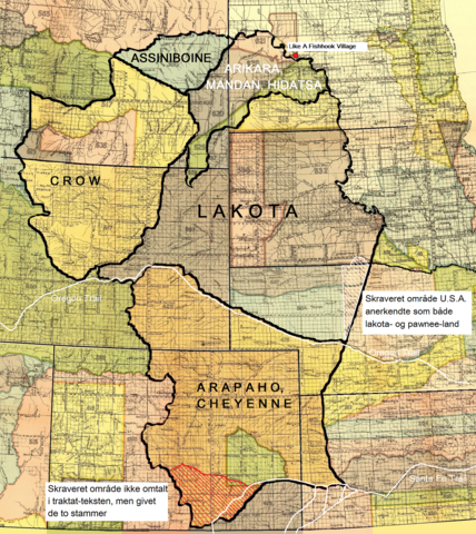
Dansk: Fort Laramie traktatens (1851) territorier for lakota-, cheyenne- og arapaho-, crow-, assiniboine- samt mandan-, hidatsa- og arikara-stammen. Endvidere Like A Fishhook Village, Oregon Trail, Santa Fe Trail samt området syd for Arkansas River tildelt cheyennerne- og arapahoerne p.g.a. en misforstået traktattekst (rød skravering). Også området anerkendt som både lakota- og pawnee-land af U.S.A. (hvid skravering).
English: The territories of the Lakota, Cheyenne and Arapaho, Crow, Assiniboine and Mandan, Hidatsa and Arikara tribes. Also Like A Fishhook Village, Oregon Trail and Santa Fe Trail. Further, the south area added to the territory of the Cheyenne and Arapaho due to a misunderstanding of the treaty text (red hatching) – (see ”Historical data and remarks”. U.S Serial Set, Number 4015, 56. Congress, 1. Session. P. 786.) Also the area recognized by the U.S. as territory of both the Lakota and the Pawnee (white hatching) - (See Blaine, Martha Royce: ”Pawnee Passage, 1870-1875.” Norman and London. 1990. P. 212. Also Royce, Charles C.: ”Indian Land Cessions in the United States.” Bureau of American Ethnology. Eighteenth Annual Report. Part 2. Washington, 1899. P. 819.) |
| Дата | |
| Источник | Royce, Charles C.: Indian Land Cessions in the United States. Bureau of American Ethnology. Eighteenth Annual Report. Part 2. Washington, 1899. GPO |
| Автор | Compiled by Charles C, Royce (original maps now adapted to written text) |
Лицензирование
| This work is from the Library of Congress. According to the library, there are no known copyright restrictions on the use of this work. |  |

|
This is a file uploaded through the Danish Wikipedia, which has not been reviewed on Commons:
|
История файла
Нажмите на дату/время, чтобы посмотреть файл, который был загружен в тот момент.
| Дата/время | Миниатюра | Размеры | Участник | Примечание | |
|---|---|---|---|---|---|
| текущий | 09:02, 9 января 2022 | | 1243 × 1395 (4,3 МБ) | Indianertosset | Uploaded a work by Compiled by Charles C, Royce (original maps now adapted to written text) from Royce, Charles C.: Indian Land Cessions in the United States. Bureau of American Ethnology. Eighteenth Annual Report. Part 2. Washington, 1899. GPO with UploadWizard |
Использование файла
Нет страниц, использующих этот файл.
Глобальное использование файла
Данный файл используется в следующих вики:
- Использование в da.wikipedia.org
- Использование в it.wikipedia.org