Файл:Frozen Franz Josef Land - NASA Earth Observatory.jpg
Исходный файл (720 × 720 пкс, размер файла: 183 КБ, MIME-тип: image/jpeg)
Этот файл находится на Викискладе. Сведения о нём показаны ниже.
Викисклад — централизованное хранилище для свободных файлов, используемых в проектах Викимедиа.
|
Краткое описание
| Описание |
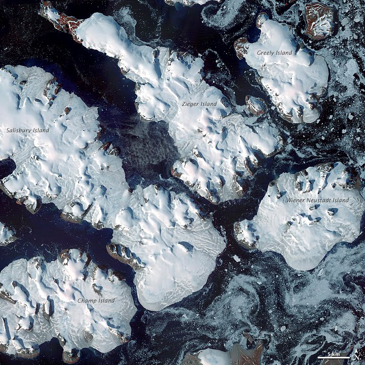
To download the full resolution and other files go to: earthobservatory.nasa.gov/IOTD/view.php?id=76883&src=... Located just 600 miles (970 kilometers) from the North Pole, Franz Josef Land is perpetually coated with ice. Glaciers cover roughly 85 percent of the archipelago’s land masses, and sea ice floats in the channels between islands even in the summertime. The Advanced Spaceborne Thermal Emission and Reflection Radiometer (ASTER) on NASA’s Terra satellite observed the islands of central Franz Josef Land on August 16 and 19, 2011. (Another sensor on Terra captured a wider view on August 17, 2011.) The image above was made from a combination of visible and near-infrared wavelengths, and ice appears in shades of white and pale blue. The amount of sea ice filling the channels between the islands of Franz Josef Land varies from summer to summer. Captured toward the end of the Northern Hemisphere melt season, this shot shows a modest amount of sea ice on the ocean surface. Some of the ice has accumulated in bays like the one near northeastern Zieger Island. Most of the ice in this scene is anchored to land, as large glaciers blanket the islands. Yet today’s glaciers are tiny compared to the ice sheet that dominated the region about 20,000 years ago. Studies of Franz Josef Land have actually contributed to a larger understanding of when that massive ice sheet began its slow retreat. Raised beaches, which preserve evidence of land rising as the crushing weight of overlying glaciers eases (known as isostatic rebound), were first recognized on the islands in the late nineteenth century. Researchers estimate that the giant ice sheet had retreated by about 10,000 years ago. NASA image created by Jesse Allen, using data provided courtesy of NASA/GSFC/METI/ERSDAC/JAROS, and U.S./Japan ASTER Science Team. Caption by Michon Scott with information from Walt Meier and Ted Scambos, National Snow and Ice Data Center. The Earth Observatory's mission is to share with the public the images, stories, and discoveries about climate and the environment that emerge from NASA research, including its satellite missions, in-the-field research, and climate models. Like us on Facebook Follow us on Twitter Add us to your circles on Google+ |
| Дата | |
| Источник | Frozen Franz Josef Land |
| Автор | NASA's Earth Observatory |
| Местоположение камеры | | Это и другие изображения по их местоположению на OpenStreetMap |
|---|
Лицензирование
- Вы можете свободно:
- делиться произведением – копировать, распространять и передавать данное произведение
- создавать производные – переделывать данное произведение
- При соблюдении следующих условий:
- атрибуция – Вы должны указать авторство, предоставить ссылку на лицензию и указать, внёс ли автор какие-либо изменения. Это можно сделать любым разумным способом, но не создавая впечатление, что лицензиат поддерживает вас или использование вами данного произведения.
| Это изображение изначально опубликовано на Flickr участником проекта NASA Earth Observatory по ссылке https://www.flickr.com/photos/68824346@N02/6653043801. Оно было досмотрено 2 июля 2012 роботом FlickreviewR, который подтвердил, что изображение лицензировано в соответствии с условиями cc-by-2.0. |
История файла
Нажмите на дату/время, чтобы посмотреть файл, который был загружен в тот момент.
| Дата/время | Миниатюра | Размеры | Участник | Примечание | |
|---|---|---|---|---|---|
| текущий | 17:14, 2 июля 2012 | | 720 × 720 (183 КБ) | Dzlinker | == {{int:filedesc}} == {{Information |Description=To download the full resolution and other files go to: [http://earthobservatory.nasa.gov/IOTD/view.php?id=76883&src=flickr earthobservatory.nasa.gov/IOTD/view.php?id=76883&src=...] Located just 600 mil... |
Использование файла
Нет страниц, использующих этот файл.
Глобальное использование файла
Данный файл используется в следующих вики:
- Использование в ast.wikipedia.org
- Использование в avk.wikipedia.org
- Использование в cs.wikipedia.org
- Использование в de.wikipedia.org
- Использование в en.wikipedia.org
- Использование в fr.wikipedia.org
- Использование в gl.wikipedia.org
- Использование в ja.wikipedia.org
- Использование в nn.wikipedia.org
- Использование в no.wikipedia.org
- Использование в pl.wikipedia.org
- Использование в pt.wikipedia.org
- Использование в ro.wikipedia.org