Файл:Geologische Strukturen im Gebiet Noctis Labyrinthus (53484482841).jpg
Перейти к навигации
Перейти к поиску

Размер этого предпросмотра: 371 × 598 пкс. Другие разрешения: 149 × 240 пкс | 297 × 480 пкс | 476 × 768 пкс | 635 × 1024 пкс | 1269 × 2048 пкс | 6000 × 9679 пкс.
Исходный файл (6000 × 9679 пкс, размер файла: 7,13 МБ, MIME-тип: image/jpeg)
Этот файл находится на Викискладе. Сведения о нём показаны ниже.
Викисклад — централизованное хранилище для свободных файлов, используемых в проектах Викимедиа.
|
.jpg?uselang=ru)
Краткое описание
| Описание |
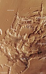
Deutsch: In dem an aufregenden geologischen Phänomenen sehr reichen südlichen Marshochland stellt die durch tektonische Dehnungsvorgänge entstandene Region Noctis Labyrinthus noch mal ein ganz besonderes Gebiet dar. Im Text wird unter anderem auf die hier markierten geologischen Strukturen eingegangen: „graben structures“ sind tektonische Dehnungsstrukturen, bei denen Teile der Landschaft entlang von Bruchlinien abgesackt sind; „chaotic terrain“, also chaotisches Gebiet, ist ein Fachterminus für eine durch Erosionsprozesse gestaltete Landschaft, in der von der Erosion noch nicht vollkommen verwitterte Fels- oder Bergblöcke „chaotisch“ angeordnet sind; „very large ripples“ sind lange, hohe und 150 bis 200 Meter voneinander entfernte, senkrecht zur Windrichtung angeordnete Dünenkämme; „channel emerging“ zeigt einen von Wasser in den Talgrund erodiertes kleines Flusstal; „light toned materials“ sind helle Ablagerungen von hydratisierten, also vom Kontakt mit Wasser veränderte Mineralien; „large landslide“ zeigt die Überreste eines Bergrutsches entlang einer etwa 50 Kilometer langen und drei Kilometer hohen Abbruchkante.
Bild: 5/7, Credit: ESA/DLR/FU Berlin CCBY-SA 3.0 IGO English: In the southern Martian highlands, which are very rich in exciting geological phenomena, the Noctis Labyrinthus region, which was created by tectonic expansion processes, represents a very special area. The text deals, among other things, with the geological structures marked here: “graben structures” are tectonic expansion structures in which Parts of the landscape have sagged along fault lines; “Chaotic terrain” is a technical term for a landscape shaped by erosion processes in which rock or mountain blocks that have not yet been completely weathered by erosion are arranged “chaotically”; “very large ripples” are long, high dune ridges 150 to 200 meters apart and arranged perpendicular to the wind direction; “channel emerging” shows a small river valley eroded by water into the valley floor; “Light toned materials” are light-colored deposits of hydrated minerals, i.e. minerals that have been changed by contact with water; “Large landslide” shows the remains of a landslide along a cliff edge that is approximately 50 kilometers long and three kilometers high. Image: 5/7, Credit: ESA/DLR/FU Berlin CCBY-SA 3.0 IGO |
| Дата | Снято: 22 января 2024, 14:00:42 |
| Источник | Geologische Strukturen im Gebiet Noctis Labyrinthus |
| Автор | DLR_de |
| Flickr set | Mars Express |
| Flickr tags | marsexpress; mars |
Лицензирование
Этот файл доступен по лицензии Creative Commons Attribution-Share Alike 2.0 Generic
- Вы можете свободно:
- делиться произведением – копировать, распространять и передавать данное произведение
- создавать производные – переделывать данное произведение
- При соблюдении следующих условий:
- атрибуция – Вы должны указать авторство, предоставить ссылку на лицензию и указать, внёс ли автор какие-либо изменения. Это можно сделать любым разумным способом, но не создавая впечатление, что лицензиат поддерживает вас или использование вами данного произведения.
- распространение на тех же условиях – Если вы изменяете, преобразуете или создаёте иное произведение на основе данного, то обязаны использовать лицензию исходного произведения или лицензию, совместимую с исходной.
| Это изображение изначально опубликовано на Flickr участником проекта DLR_de по ссылке https://flickr.com/photos/48213136@N06/53484482841. Оно было досмотрено 25 января 2024 роботом FlickreviewR 2, который подтвердил, что изображение лицензировано в соответствии с условиями cc-by-sa-2.0. |
| This media has been released under a free license by the Deutsches Zentrum für Luft- und Raumfahrt (DLR). Their website states: "Where expressly stated, DLR images and videos are covered by a Creative Commons Attribution 3.0 Germany (CC BY 3.0) licence. This licence grants permission to reproduce or distribute the work, to make the work and/or its contents publically available, to alter or edit the work and/or its contents and to make commercial use of the work, provided that you explicitly mention DLR as its source in a clearly legible format. Examples: 'Photo: DLR, CC-BY 3.0', 'Images: DLR, CC-BY 3.0', 'Video: DLR, CC-BY 3.0'." To the uploader: You must provide a link (URL) to the original file and the authorship information if available. |
Этот файл доступен по лицензии Creative Commons Attribution 3.0 Германия.
Атрибуция: DLR, CC-BY 3.0
- Вы можете свободно:
- делиться произведением – копировать, распространять и передавать данное произведение
- создавать производные – переделывать данное произведение
- При соблюдении следующих условий:
- атрибуция – Вы должны указать авторство, предоставить ссылку на лицензию и указать, внёс ли автор какие-либо изменения. Это можно сделать любым разумным способом, но не создавая впечатление, что лицензиат поддерживает вас или использование вами данного произведения.

This media was created by the European Space Agency (ESA).
Where expressly so stated, images or videos are covered by the Creative Commons Attribution-ShareAlike 3.0 IGO (CC BY-SA 3.0 IGO) licence, ESA being an Intergovernmental Organisation (IGO), as defined by the CC BY-SA 3.0 IGO licence. The user is allowed under the terms and conditions of the CC BY-SA 3.0 IGO license to Reproduce, Distribute and Publicly Perform the ESA images and videos released under CC BY-SA 3.0 IGO licence and the Adaptations thereof, without further explicit permission being necessary, for as long as the user complies with the conditions and restrictions set forth in the CC BY-SA 3.0 IGO licence, these including that:
See the ESA Creative Commons copyright notice for complete information, and this article for additional details.
|
 | |
Этот файл доступен по лицензии Creative Commons Attribution-Share Alike 3.0 IGO. Атрибуция: ESA/DLR/FU Berlin, CC BY-SA IGO 3.0
| ||
История файла
Нажмите на дату/время, чтобы посмотреть файл, который был загружен в тот момент.
| Дата/время | Миниатюра | Размеры | Участник | Примечание | |
|---|---|---|---|---|---|
| текущий | 00:06, 25 января 2024 | | 6000 × 9679 (7,13 МБ) | OptimusPrimeBot | #Spacemedia - Upload of https://live.staticflickr.com/65535/53484482841_3f0ac5e69c_o.jpg via Commons:Spacemedia |
Использование файла
Нет страниц, использующих этот файл.
.jpg)