Перейти на страницу файла на Викискладе

Файл:Gonu 06 jun 2007 0715Z.jpg

Материал из Википедии — свободной энциклопедии
Перейти к навигации Перейти к поиску

Исходный файл(3900 × 3380 пкс, размер файла: 1,15 МБ, MIME-тип: image/jpeg)

Краткое описание

Описание

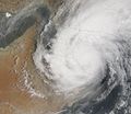
A cyclonic storm like Tropical Cyclone Gonu might not seem an odd sight until you consider that Gonu is heading northwest into the Gulf of Oman. The most recent storm of this magnitude to hit the Sultanate of Oman was in 1977, according to AlJazeera.net (English language). Given the rarity of these storms in the area, many shore facilities were never constructed to deal with the severe winds, strong rains, and high storm surge.

At 10:15 a.m. local time (07:15 UTC) on June 6, 2007, when the Moderate Resolution Imaging Spectroradiometer (MODIS) on NASA’s Terra satellite captured this image, Tropical Cyclone Gonu was grazing the gulf shore of Oman. At this time, the powerful storm had lost considerable power and was considered a Category 1 cyclone. Sustained winds were measured at 140 kilometers per hour (85 miles per hour) according to the University of Hawaii’s Tropical Storm Information Center.

The satellite image shows Gonu bringing rain to both Oman and Iran even as the storm center remains offshore in the Gulf of Oman. Hemmed in by hot desert lands and mountains on both sides of the Gulf, Gonu was predicted to continue to move up the Gulf and lose power before making landfall in southeastern Iran. Because such storms are virtually unheard of in this part of the world, authorities treated the storm with considerable caution: government offices in Oman and most private businesses declared a holiday from June 5 until June 9. They recommended people stay in their homes as much as possible and stock basic supplies and emergency needs, according to Middle East Online. Residents in low-lying coastal areas in southeastern Iran were also being evacuated, while the fishing fleet in neighboring Pakistan was ordered to stay in as waves battered the shores. Gonu, however, did not appear poised to reach the Straits of Hormuz, and oil shipping from the Persian Gulf had not been significantly disrupted as of June 6, according to a number of news services.
Дата
Источник http://earthobservatory.nasa.gov/NaturalHazards/natural_hazards_v2.php3?img_id=14292
Автор NASA image by Jesse Allen, using data provided courtesy of the MODIS Rapid Response team at Goddard Space Flight Center.
Права
(Повторное использование этого файла)
Public domain Этот файл находится в общественном достоянии (англ. public domain), так как он был создан NASA (Национальным управлением по аэронавтике и исследованию космического пространства). Политика авторского права NASA гласит, что «Материал NASA не защищается авторским правом, если не указано иное». (См. Template:PD-USGov, страницу политики авторского права NASA или политику использования изображений JPL.)
Предупреждения:

Краткие подписи

Добавьте однострочное описание того, что собой представляет этот файл

Элементы, изображённые на этом файле

изображённый объект

История файла

Нажмите на дату/время, чтобы посмотреть файл, который был загружен в тот момент.

Дата/времяМиниатюраРазмерыУчастникПримечание
текущий15:18, 9 июня 2007Миниатюра для версии от 15:18, 9 июня 20073900 × 3380 (1,15 МБ)Good kitty== Summary == {{Information |Description=A cyclonic storm like Tropical Cyclone Gonu might not seem an odd sight until you consider that Gonu is heading northwest into the Gulf of Oman. The most recent storm of this magnitude to hit the Sultanate of Oman

Нет страниц, использующих этот файл.

Глобальное использование файла

Данный файл используется в следующих вики:

Метаданные