Файл:Gulf of Carpentaria (MODIS 2017-07-09).jpg

Исходный файл (3565 × 2721 пкс, размер файла: 974 КБ, MIME-тип: image/jpeg)
Этот файл находится на Викискладе. Сведения о нём показаны ниже.
Викисклад — централизованное хранилище для свободных файлов, используемых в проектах Викимедиа.
|
.jpg?uselang=ru)
Краткое описание
| Описание |
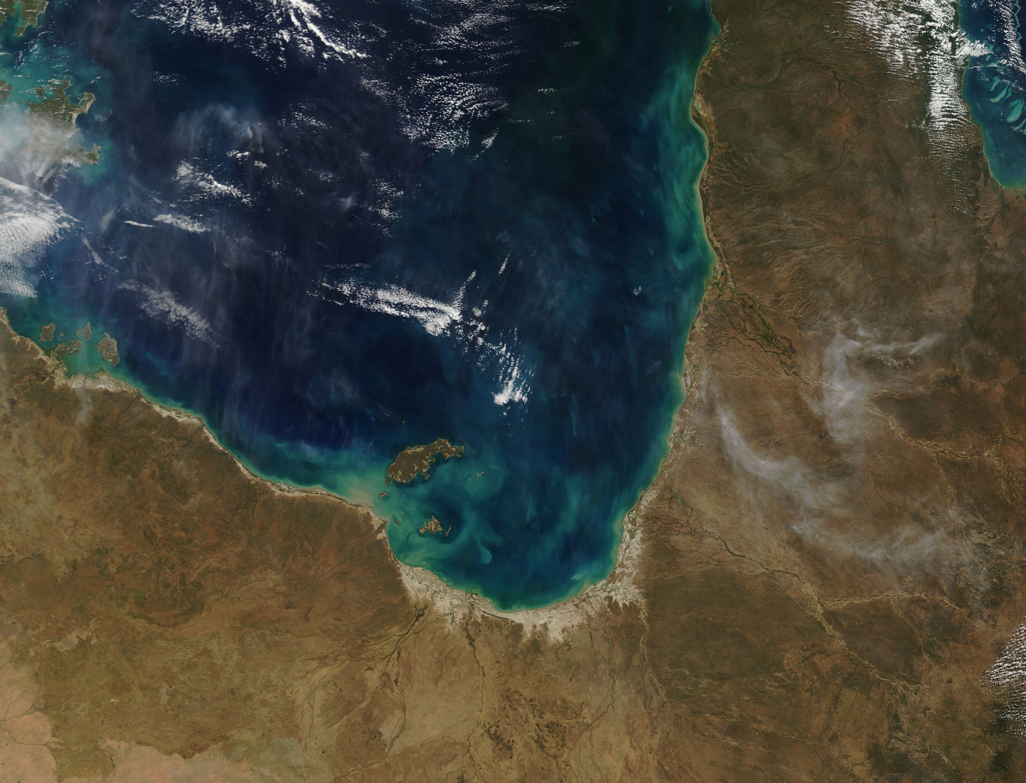
English: Swirls of tan, blue, and green marked sediment and phytoplankton in the Gulf of Carpentaria, Australia in late June 2017. The Moderate Resolution Imaging Spectroradiometer (MODIS) aboard NASA’s Terra satellite acquired this true-colored image on June 26.
The Gulf of Carpentaria is bounded on the south and east by Queensland and on the west by Northern Territory, Australia. Runoff from several rivers brings tan sediment into the Gulf and runoff from the land also deposits sediment. When shallow, sediment appears tan but as it sinks under the water its reflective properties change, so the color as viewed from space also changes from tan to blues and green. Sediment can also provide nutrients to phytoplankton – single, plant-like, chlorophyll-containing organisms – and encourage massive growth. When phytoplankton grows in large numbers, the blooms can easily be seen from space. The skies over the blue waters of the Gulf are streaked with what appears to be both cloud and haze or smoke. Cloud appears bright white and appears in several locations. Several banks are lined in a northwest to southeast direction. The haze or smoke appears to be in a higher level in the atmosphere as it hangs over the cloud in many areas. It also blows roughly parallel to the cloud. Smoke from several fires can be seen in Queensland, where the smoke first rises then blows generally to the southeast or eastward. |
||
| Дата | Снято: 26 июня 2017 | ||
| Источник |
Gulf of Carpentaria (direct link)
|
||
| Автор | Jeff Schmaltz, MODIS Land Rapid Response Team, NASA GSFC |
| This media is a product of the Terra mission Credit and attribution belongs to the mission team, if not already specified in the "author" row |
Лицензирование
| Этот файл находится в общественном достоянии (англ. public domain), так как он был создан NASA (Национальным управлением по аэронавтике и исследованию космического пространства). Политика авторского права NASA гласит, что «Материал NASA не защищается авторским правом, если не указано иное». (См. Template:PD-USGov, страницу политики авторского права NASA или политику использования изображений JPL.) | ||
 |
Предупреждения:
|
История файла
Нажмите на дату/время, чтобы посмотреть файл, который был загружен в тот момент.
| Дата/время | Миниатюра | Размеры | Участник | Примечание | |
|---|---|---|---|---|---|
| текущий | 18:34, 16 февраля 2024 | | 3565 × 2721 (974 КБ) | OptimusPrimeBot | #Spacemedia - Upload of http://modis.gsfc.nasa.gov/gallery/images/image07092017_250m.jpg via Commons:Spacemedia |
Использование файла
Нет страниц, использующих этот файл.
.jpg)