Файл:Gulf of Carpentaria (MODIS 2022-05-16).jpg

Исходный файл (1451 × 1118 пкс, размер файла: 169 КБ, MIME-тип: image/jpeg)
Этот файл находится на Викискладе. Сведения о нём показаны ниже.
Викисклад — централизованное хранилище для свободных файлов, используемых в проектах Викимедиа.
|
.jpg?uselang=ru)
Краткое описание
| Описание |
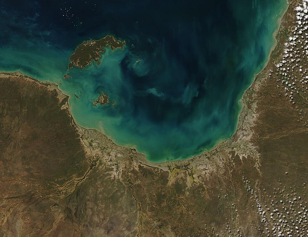
English: Glorious gem-like colors tinted the near-shore waters of the Gulf of Carpentaria in mid-May 2022. The Moderate Resolution Imaging Spectroradiometer (MODIS) on board NASA’s Aqua satellite acquired a true-color image of the southern section of the Gulf on May 13.
The Gulf of Carpentaria sits in the top (north) of Australia, with Northern Territory on the west, Queensland on the east, and the Arafura Sea in the north. Spanning about 300,000 square kilometers (115,830 square miles), the area of the Gulf is nearly the size of Italy. Despite its large size, the Gulf of Carpentaria is shallow, averaging 55 to 66 meters (180 to 217 feet) and a maximum depth of only 82 meters (269 feet). There are two major seasons in this region – the dry season (April to November) and the wet season, when rains fall on the Gulf as well as fill the rivers that pour into it, including the Gilbert River, Cox River, Mission River, McArthur River, and Bynoe River. Rich in biodiversity, the warm waters are home to a sunken coral reef, large seagrass meadows, sections of soft sandy seafloor, undersea pinnacles, and a coastal zone where freshwater meets the salty waters, each contributing to the large amount of life living here. The reefs contain many species unique to the region, including a diverse community of large plate corals, abundant soft corals and dense sponge corals. Seagrass meadows host herds of dugong, sea turtles, and pipefish. The waters of the Gulf of Carpentaria are also home to sea snakes, sharks, turtles, and a rich diversity of commercial fish species as well as prawn, which are harvested in large numbers. The shores of the southern Gulf are especially important for a variety of bird species, especially waders and shorebirds. A portion of the southeastern shore has been recognized as an Important Bird and Biodiversity Area (IBA) by BirdLife International. |
||
| Дата | Снято: 13 мая 2022 | ||
| Источник |
Gulf of Carpentaria (direct link)
|
||
| Автор | MODIS Land Rapid Response Team, NASA GSFC |
| This media is a product of the Aqua mission Credit and attribution belongs to the mission team, if not already specified in the "author" row |
Лицензирование
| Этот файл находится в общественном достоянии (англ. public domain), так как он был создан NASA (Национальным управлением по аэронавтике и исследованию космического пространства). Политика авторского права NASA гласит, что «Материал NASA не защищается авторским правом, если не указано иное». (См. Template:PD-USGov, страницу политики авторского права NASA или политику использования изображений JPL.) | ||
 |
Предупреждения:
|
История файла
Нажмите на дату/время, чтобы посмотреть файл, который был загружен в тот момент.
| Дата/время | Миниатюра | Размеры | Участник | Примечание | |
|---|---|---|---|---|---|
| текущий | 22:04, 9 января 2024 | | 1451 × 1118 (169 КБ) | OptimusPrimeBot | #Spacemedia - Upload of http://modis.gsfc.nasa.gov/gallery/images/image05162022_250m.jpg via Commons:Spacemedia |
Использование файла
Нет страниц, использующих этот файл.
.jpg)