Файл:Gulf of Khambhat (MODIS).jpg
Перейти к навигации
Перейти к поиску

Размер этого предпросмотра: 776 × 600 пкс. Другие разрешения: 311 × 240 пкс | 621 × 480 пкс | 994 × 768 пкс | 1280 × 990 пкс | 1362 × 1053 пкс.
Исходный файл (1362 × 1053 пкс, размер файла: 199 КБ, MIME-тип: image/jpeg)
Этот файл находится на Викискладе. Сведения о нём показаны ниже.
Викисклад — централизованное хранилище для свободных файлов, используемых в проектах Викимедиа.
|
.jpg?uselang=ru)
Краткое описание
| Описание |
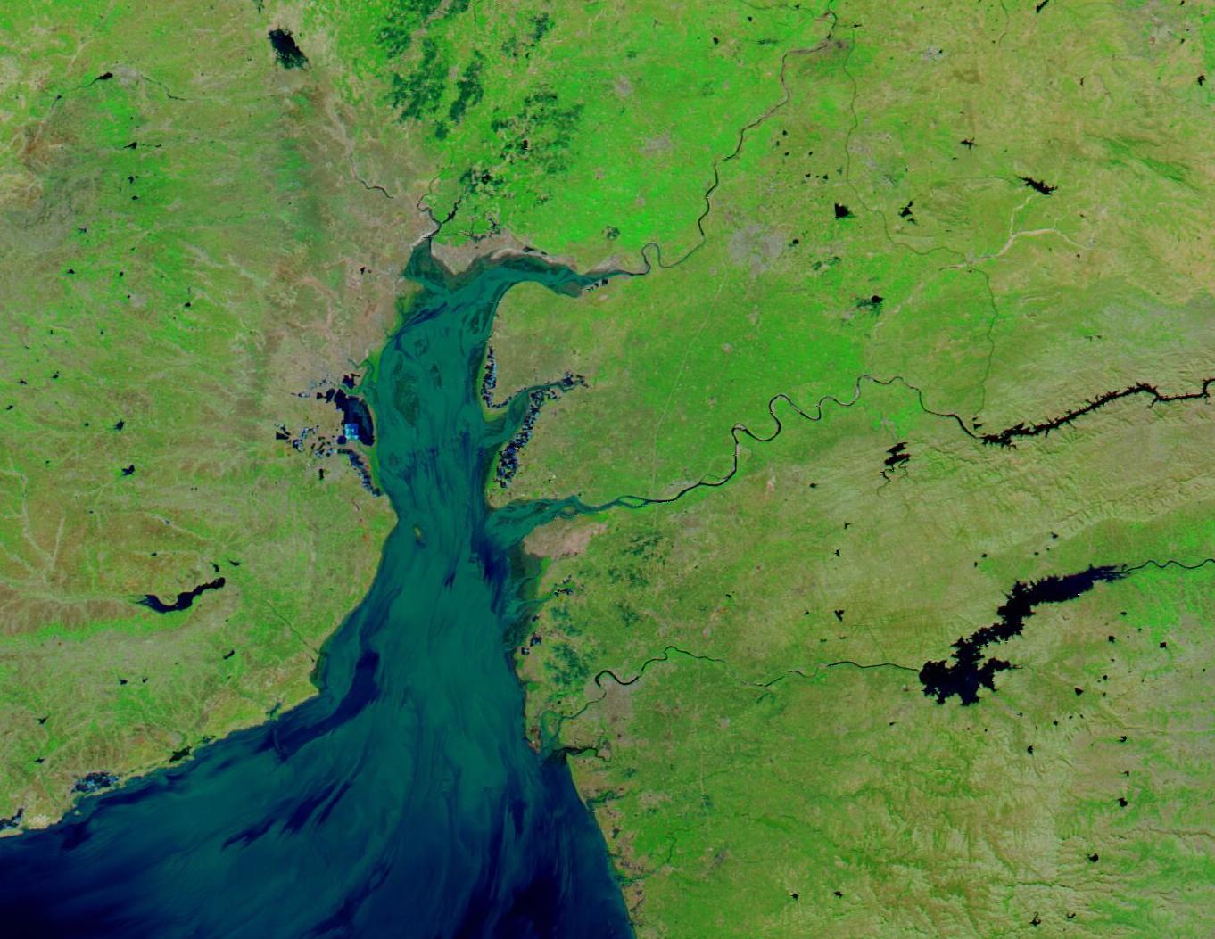
English: The Gulf of Khambhat is a trumpet-shaped extension of the Arabian Sea, lying on the west coast of India between the Saurashtra Peninsula and mainland Gujarat. At the northern end, the Gulf is only about 15 miles (24 km) wide, but it expands to about 120 miles (190 km) at the widest point in the south.
Several major river systems—including the Narmada, Tapi, Mahi, Sabarmati, and Shetrunji—deliver abundant freshwater and heavy sediment loads to the gulf. The gulf measures 80 kilometers (50 miles) wide at its mouth in the Arabian Sea but narrows to about 25 kilometers (15 miles) at its head, where the deltas of the Sabarmati and Mahi rivers meet. On February 12, 2023, the Moderate Resolution Imaging Spectroradiometer (MODIS) on board NASA’s Aqua satellite acquired a false-color image of the Gulf of Khambhat. In this type of image, vegetation is bright green, open land is tan, water appears blue or inky black with deeper water looking darker. Suspended sediment, which can be seen entering the Gulf from many of the rivers, appears dull green near the surface but takes on blue tones as it sinks and disperses. A bright electric blue area along the western coast of the Gulf are crusts of minerals on salt ponds near Bhavnagar, Gujarat. With more than 50 percent of salt workers located in Gujarat, the state accounts for almost three-quarters of the country's annual salt production. |
||
| Дата | Снято: 12 февраля 2023 | ||
| Источник |
Gulf of Khambhat (direct link)
|
||
| Автор | MODIS Land Rapid Response Team, NASA GSFC |
| This media is a product of the Aqua mission Credit and attribution belongs to the mission team, if not already specified in the "author" row |
Лицензирование
| Этот файл находится в общественном достоянии (англ. public domain), так как он был создан NASA (Национальным управлением по аэронавтике и исследованию космического пространства). Политика авторского права NASA гласит, что «Материал NASA не защищается авторским правом, если не указано иное». (См. Template:PD-USGov, страницу политики авторского права NASA или политику использования изображений JPL.) | ||
 |
Предупреждения:
|
История файла
Нажмите на дату/время, чтобы посмотреть файл, который был загружен в тот момент.
| Дата/время | Миниатюра | Размеры | Участник | Примечание | |
|---|---|---|---|---|---|
| текущий | 20:03, 31 июля 2023 | | 1362 × 1053 (199 КБ) | OptimusPrimeBot | #Spacemedia - Upload of http://modis.gsfc.nasa.gov/gallery/images/image02202023_250m.jpg via Commons:Spacemedia |
Использование файла
Нет страниц, использующих этот файл.
.jpg)