Файл:Hamm, Lippeauen -- 2014 -- 8816 crop.jpg
Перейти к навигации
Перейти к поиску

Размер этого предпросмотра: 800 × 549 пкс. Другие разрешения: 320 × 220 пкс | 640 × 439 пкс | 1024 × 703 пкс | 1280 × 878 пкс | 2705 × 1856 пкс.
Исходный файл (2705 × 1856 пкс, размер файла: 4,95 МБ, MIME-тип: image/jpeg)
Этот файл находится на Викискладе. Сведения о нём показаны ниже.
Викисклад — централизованное хранилище для свободных файлов, используемых в проектах Викимедиа.
|
Краткое описание
| Описание |
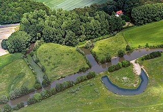
Deutsch: Lippeauen mit ehemaliger Flussschleife „Alte Lippe“ in Hamm und Ahlen, Nordrhein-Westfalen, Deutschland
Die Lippe bildet hier die Gemeindegrenze zwischen den Städten Hamm (südlich des Flusses, unten im Bild) und Ahlen (nördlich, oben im Bild). Die abgebildeten Bereiche der Lippeauen gehören zu den Naturschutzgebieten „Oberwerrieser Mersch“ (NSG HAM-010 in Hamm) und „Lippeaue zwischen Schloss Oberwerries und Dolberg“ (NSG WAF-034 in Ahlen). Die Bundesstraße 61 (Heessener Straße) verläuft oben durchs Bild, in der Ecke oben rechts befindet sich Hof Düpmeier.
|
||||||||||||||||||||||||||||||
| Место | |||||||||||||||||||||||||||||||
| Изображённый объект | ландшафт – однородная по азональным признакам конкретная территория | ||||||||||||||||||||||||||||||
| Техническая Характеристика |
|
||||||||||||||||||||||||||||||
| Данные изображения |
|
||||||||||||||||||||||||||||||
| Дата | Снято: 1 июня 2014, 13:31 | ||||||||||||||||||||||||||||||
| Источник | Собственная работа | ||||||||||||||||||||||||||||||
| Автор | Оригинал: Dietmar Rabich (Производное произведение: Lämpel) Derivative work Lämpel | ||||||||||||||||||||||||||||||
| Права (Повторное использование этого файла) |
 .svg) I. Licence
This photograph is protected by copyright law. It is a derivative by Lämpel of the original photograph taken by Dietmar Rabich. However, it may be used for free by anyone, provided it is used in accordance with the license Creative Commons License “Attribution-ShareAlike 4.0 International” (CC BY-SA 4.0). These include, among other things, the naming of the author and the license, as well as the setting of a link to the license text or its complete imprint. The attribution has to be done as follows:
Оригинал: Dietmar Rabich (Производное произведение: Lämpel) / Wikimedia Commons / /
Please read the text of the license carefully before using the photograph. If you do not agree with the conditions of the license or if you do not understand these conditions, please refrain from using the photo. If you do not comply with the terms of the license, you do not acquire any right to use the image.
For informations about the licence see section Лицензирование or as human-readable summary or as full licence text at Creative Commons. In addition to the above, a link to the source - so this page with the descriptions and license terms - is appreciated. More information or examples of use can be found at re-use (with example file).
As an alternative to the Creative Commons License CC BY-SA 4.0, the Free Art License (from version 1.3) may also be used.
II. Fairness
From printed materials and other tangible products that use that work, the user is asked to send a copy to the author as thank you. The mailing address can be requested via the contact options.
III. Disclaimer
Please note that the license applies solely for the reuse of the photograph itself. The license doesn't grant you any right regarding the depicted object (eg, copyright or proprietary rights) or the personality rights of the person eventually shown. I do not grant any warranty that the subsequent use of the photograph is legally possible concerning the object or person shown in the photograph. You are responsible to check and respect these rights in the publication in the respective medium or country.
The author is not responsible for the accuracy of the information contained herein (description, title, etc.). Likewise, the author assumes no liability for further use. Please note the general disclaimer and please read reusing content outside Wikimedia too. |
||||||||||||||||||||||||||||||
| Другие версии |
|
||||||||||||||||||||||||||||||
| Атрибуция (требуется лицензией) | Оригинал: Dietmar Rabich (Производное произведение: Lämpel) / Wikimedia Commons / /
|
||||||||||||||||||||||||||||||
| Ключевые слова | Aerial view, Ahlen, Architecture, Architektur, Baum, Bauwerk, Bodies of water, Bundesstraße 61, Castle, Deutschland, Einundsechzig, Flora, Fluss, Frühling, Geographie, Germany, Gewässer, Hamm, Heessen, Kreis Warendorf, Kultur, Landscape, Landschaft, Landschaftsfotografie, Licht und Schatten, Luftaufnahme, Luftbild, Münsterland, Natur, Naturschutzgebiet, Nordrhein-Westfalen, North Rhine-Westphalia, Pflanze, Plant, River, Road, Schatten, Schloss, Schloss Oberwerries, Schutzgebiet, Straße, Straßen und Wege, Street, Transport, Tree, Verkehr, Wasser, Westfalen, Wetter, Wolke, Wolkenlandschaftsfotografie, 2014, 61 | ||||||||||||||||||||||||||||||


| Местоположение камеры | | Это и другие изображения по их местоположению на OpenStreetMap |
|---|
|
Место |
The geocoded location of the location of this image is only correct to the nearest 3 km for privacy or other reasons. Please do not improve the accuracy of the coordinates even if you are able to do so. |
|---|
| Dieses Foto entstand aufgrund eines Projektes, das von Wikimedia Deutschland e. V. gefördert wurde.
Im Rahmen des „Community-Projektbudgets“ sollen Luftbilder u. a. vom Münsterland angefertigt werden. Das Projekt „Fotoflüge“ wurde im September 2011 begonnen. Ziel dieses Fotoflugs war das östliche Münsterland. Flüge des Projekts im Münsterland: 12. April 2014 · 1. Juni 2014 · 7. Juni 2014 · 20. Juli 2014 · 1. November 2014 |
Лицензирование
Оригинал: Dietmar Rabich (Производное произведение: Lämpel), владелец авторских прав на это произведение, добровольно публикует его на условиях следующей лицензии:
Этот файл доступен по лицензии Creative Commons Attribution-Share Alike 4.0 International
Атрибуция: Оригинал: Dietmar Rabich (Производное произведение: Lämpel)
- Вы можете свободно:
- делиться произведением – копировать, распространять и передавать данное произведение
- создавать производные – переделывать данное произведение
- При соблюдении следующих условий:
- атрибуция – Вы должны указать авторство, предоставить ссылку на лицензию и указать, внёс ли автор какие-либо изменения. Это можно сделать любым разумным способом, но не создавая впечатление, что лицензиат поддерживает вас или использование вами данного произведения.
- распространение на тех же условиях – Если вы изменяете, преобразуете или создаёте иное произведение на основе данного, то обязаны использовать лицензию исходного произведения или лицензию, совместимую с исходной.
Notes
История файла
Нажмите на дату/время, чтобы посмотреть файл, который был загружен в тот момент.
| Дата/время | Миниатюра | Размеры | Участник | Примечание | |
|---|---|---|---|---|---|
| текущий | 12:33, 1 февраля 2024 | | 2705 × 1856 (4,95 МБ) | Lämpel | {{Information |description = {{de|Lippeauen mit ehemaliger Flussschleife „Alte Lippe“ in Hamm und Ahlen, Nordrhein-Westfalen, Deutschland<br/><small>Die Lippe bildet hier die Gemeindegrenze zwischen den Städten Hamm (südlich des Flusses, unten im Bild) und Ahlen (nördlich, oben im Bild). Die abgebildeten Bereiche der Lippeauen gehören zu den Naturschutzgebieten „Oberwerrieser Mersch“ (NSG HAM-010 in Hamm) und... |
Использование файла
Нет страниц, использующих этот файл.
Глобальное использование файла
Данный файл используется в следующих вики:
- Использование в de.wikipedia.org