Файл:ISS029-E-008032 Fires along the Rio Xingu - Brazil.jpg

Исходный файл (4288 × 2848 пкс, размер файла: 8,76 МБ, MIME-тип: image/jpeg)
Этот файл находится на Викискладе. Сведения о нём показаны ниже.
Викисклад — централизованное хранилище для свободных файлов, используемых в проектах Викимедиа.
|
Краткое описание
| Описание |
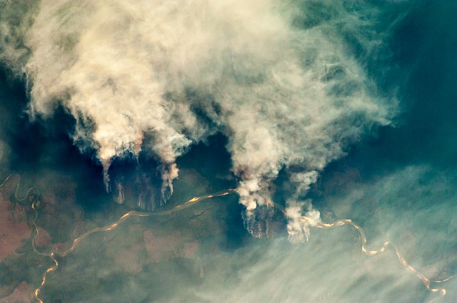
English: Slash-and-burn forest clearing along the Rio Xingu (Xingu River) in the state of Mato Grosso, Brazil.
|
||||||||||||||||||||||||||||||||||||||||||||||||||||||
| Дата | |||||||||||||||||||||||||||||||||||||||||||||||||||||||
| Источник | ISS029-E-8032 | ||||||||||||||||||||||||||||||||||||||||||||||||||||||
| Автор |
|
||||||||||||||||||||||||||||||||||||||||||||||||||||||
| Другие версии |
|
||||||||||||||||||||||||||||||||||||||||||||||||||||||


This file is in the public domain in the United States because it was created by the Image Science & Analysis Laboratory, of the NASA Johnson Space Center. NASA copyright policy states that "NASA material is not protected by copyright unless noted". (NASA media use guidelines or Conditions of Use of Astronaut Photographs).
Photo source: ISS029-E-008032.
|
Лицензирование
| Этот файл находится в общественном достоянии (англ. public domain), так как он был создан NASA (Национальным управлением по аэронавтике и исследованию космического пространства). Политика авторского права NASA гласит, что «Материал NASA не защищается авторским правом, если не указано иное». (См. Template:PD-USGov, страницу политики авторского права NASA или политику использования изображений JPL.) | ||
 |
Предупреждения:
|
История файла
Нажмите на дату/время, чтобы посмотреть файл, который был загружен в тот момент.
| Дата/время | Миниатюра | Размеры | Участник | Примечание | |
|---|---|---|---|---|---|
| текущий | 09:55, 27 апреля 2013 | | 4288 × 2848 (8,76 МБ) | Julian Herzog | User created page with UploadWizard |
Использование файла
Нет страниц, использующих этот файл.
Глобальное использование файла
Данный файл используется в следующих вики:
- Использование в af.wikipedia.org
- Использование в ar.wikipedia.org
- Использование в cs.wikipedia.org
- Использование в dag.wikipedia.org
- Использование в de.wikipedia.org
- Использование в en.wikipedia.org
- Использование в ga.wikipedia.org
- Использование в ha.wikipedia.org
- Использование в ig.wikipedia.org
- Использование в ja.wikipedia.org
- Использование в ml.wikipedia.org
- Использование в mni.wikipedia.org
- Использование в mr.wikipedia.org
- Использование в ms.wikipedia.org
- Использование в pa.wikipedia.org
- Использование в shi.wikipedia.org
- Использование в simple.wikipedia.org
- Использование в sv.wikipedia.org
- Использование в zh.wikipedia.org