Файл:Ice in Kotzebue Sound (MODIS 2021-05-29).jpg

Исходный файл (4244 × 3375 пкс, размер файла: 2,26 МБ, MIME-тип: image/jpeg)
Этот файл находится на Викискладе. Сведения о нём показаны ниже.
Викисклад — централизованное хранилище для свободных файлов, используемых в проектах Викимедиа.
|
.jpg?uselang=ru)
Краткое описание
| Описание |
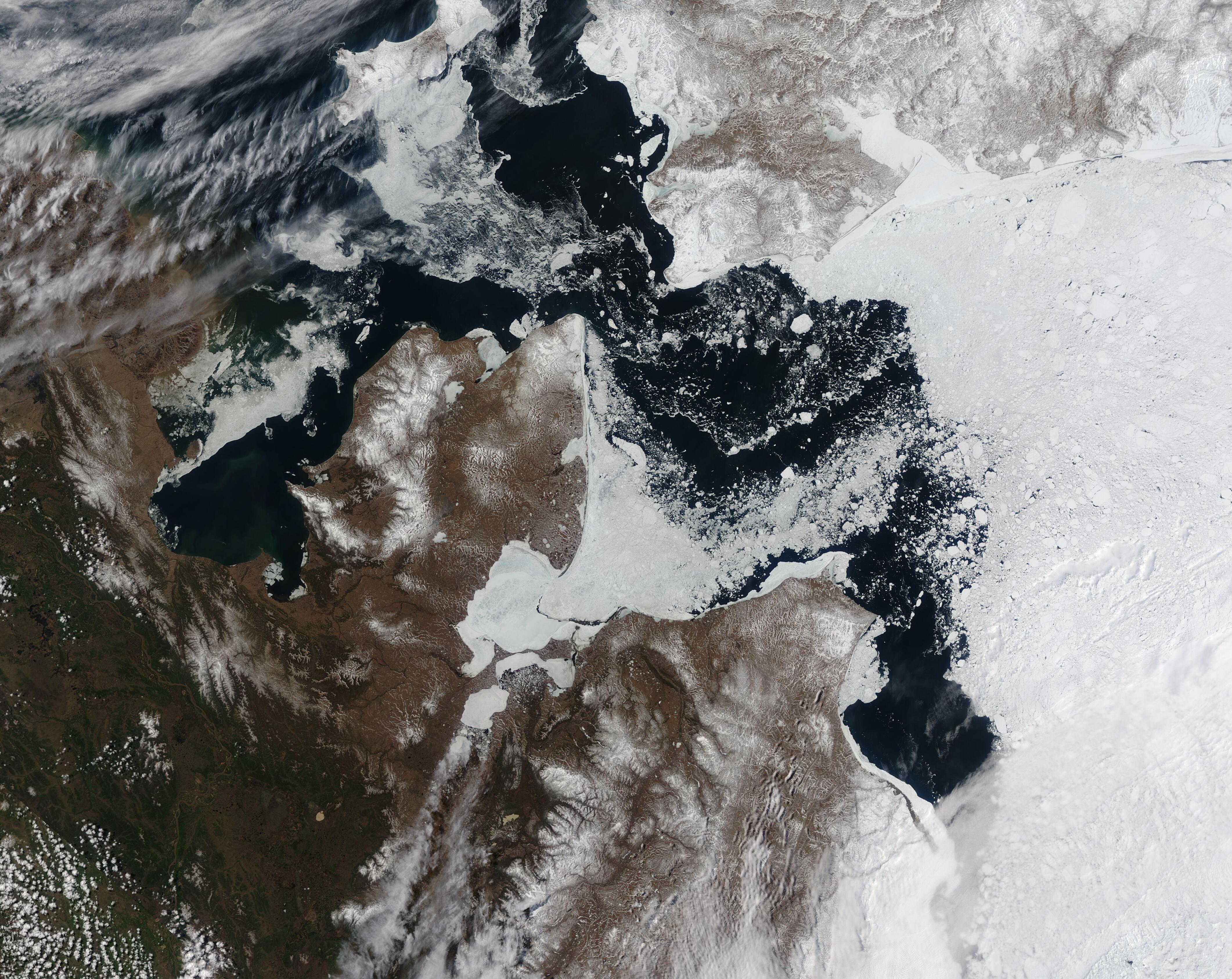
English: On May 26, 2021, the Moderate Resolution Imaging Spectroradiometer (MODIS) on board NASA’s Terra satellite acquired a true-color image of spring melt affecting the ice-filled waters between western Alaska, United States and Chukotka Autonomous Okrug, eastern Russia.
Bits of ice float freely in the mostly-open waters of the Bering Strait while fast ice clings to the Russian shoreline. Kotzebue Sound, situated between Seward Peninsula (south) and mainland Alaska (north) remains mostly ice-covered although a wide fracture indicating the start of melt appears near the town of Kotzebue. The melt date of Kotzebue Sound is particularly important to the native people who rely on an persistent and reliable ice for ice fishing and seal hunting, which are vital for subsistence and their indigenous way of life. Elders in the town recall traditional ice melt dates much later than recent years, and ice as much as five feet thick not too many years ago. Early ice melts in recent years have severely limited fishing and hunting. In 2020 there were only five safe hunt dates in the spring. The thickness of winter ice, which may be as low as one foot in recent years, also shortens the season for ice fishing. The retention of ice in Kotzebue Sound may bring a more favorable spring to the indigenous citizens of the region this spring. The Sea Ice Outlook for Western and Arctic Alaskan Coastal Waters published on May 27 by the National Weather Service, Anchorage, Alaska, states, “From the Bering Strait northward in to the Chukchi Sea, expect a more normal breakup, possible even a little delayed from the quicker breakups of the past few years.” The forecast for the Kotzebue Sound reads, “Sea ice within Kotzebue Sound may no longer be shorefast during the second week of June. Less than 3 tenths coverage is expected during the 4th week of June. Ice-free conditions are likely in the first week of July”. |
||
| Дата | Снято: 26 мая 2021 | ||
| Источник |
Ice in Kotzebue Sound (direct link)
|
||
| Автор | MODIS Land Rapid Response Team, NASA GSFC |
| This media is a product of the Terra mission Credit and attribution belongs to the mission team, if not already specified in the "author" row |
Лицензирование
| Этот файл находится в общественном достоянии (англ. public domain), так как он был создан NASA (Национальным управлением по аэронавтике и исследованию космического пространства). Политика авторского права NASA гласит, что «Материал NASA не защищается авторским правом, если не указано иное». (См. Template:PD-USGov, страницу политики авторского права NASA или политику использования изображений JPL.) | ||
 |
Предупреждения:
|
История файла
Нажмите на дату/время, чтобы посмотреть файл, который был загружен в тот момент.
| Дата/время | Миниатюра | Размеры | Участник | Примечание | |
|---|---|---|---|---|---|
| текущий | 17:45, 30 января 2024 | | 4244 × 3375 (2,26 МБ) | OptimusPrimeBot | #Spacemedia - Upload of http://modis.gsfc.nasa.gov/gallery/images/image05292021_250m.jpg via Commons:Spacemedia |
Использование файла
Нет страниц, использующих этот файл.
.jpg)