Файл:Indian campaign of 1832- map of the country (IA ruggles 408).pdf

Исходный файл (743 × 900 пкс. Размер файла: 156 КБ, MIME-тип: application/pdf. 2 страницы)
Этот файл находится на Викискладе. Сведения о нём показаны ниже.
Викисклад — централизованное хранилище для свободных файлов, используемых в проектах Викимедиа.
|
Краткое описание
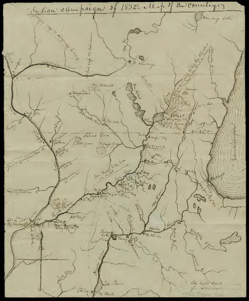
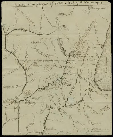
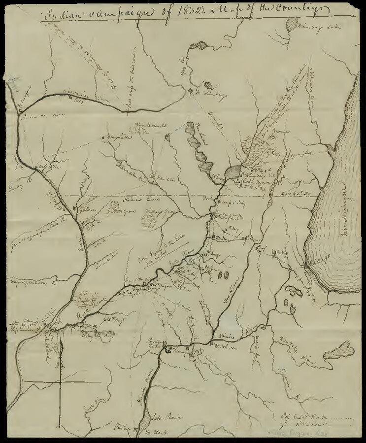
| Indian campaign of 1832: map of the country
( |
|
|---|---|
| Автор |
Rose, Edwin |
| Название |
Indian campaign of 1832: map of the country |
| Издательство |
Newberry Library |
| Описание |
Added title on verso: Map of Indian war of 1832, made by one who was there, Col. Edwin Rose. Pen-and-ink. Covers region in northern Illinois and southern Wisconsin roughly bounded by Lake Winnebago, the Kankakee River, Peoria, and Prairie du Chien. Identifies rivers, forts, towns, and distances between points. Details routes taken by U.S. forces during the Black Hawk War of 1832. Shows Gen. Henry Atkinson's June 28-July 9 route from Dixon's Ferry northeast along the Rock River and Lt. Col. Abraham Eustis's August 1-September 1 route from Chicago to Rock Island. Also identifies marshes of the upper Rock River where Sauk Indians led by Black Hawk were based and their retreat northwest from the Wisconsin River. Scale [ca. 1:1,675,000]. Subjects: Black Hawk War (1832); Indians of North America; Sauk Indians; Manuscript maps; Illinois; Wisconsin; What is the Midwest; Manuscript (Documents) |
| Язык | английский |
| Дата публикации | 1832 |
| Текущее местонахождение |
IA Collections: newberry |
| Инвентарный номер |
ruggles_408 |
| Источник | |
| Права (Повторное использование этого файла) |
The Newberry makes its collections available for any lawful purpose, commercial or non-commercial, without licensing or permission fees to the library, subject to the following terms and conditions: https://www.newberry.org/rights-and-reproductions |
Лицензирование
|
Это произведение находится в общественном достоянии в тех странах, где срок охраны авторского права равен жизни автора плюс 100 лет и менее. Это произведение находится в общественном достоянии (англ. public domain) в США, так как оно было опубликовано до 1 января 1929 года. | |
| Этот файл был определён как свободный от известных ограничений авторского права, а также связанных и смежных прав. | |
История файла
Нажмите на дату/время, чтобы посмотреть файл, который был загружен в тот момент.
| Дата/время | Миниатюра | Размеры | Участник | Примечание | |
|---|---|---|---|---|---|
| текущий | 21:29, 1 января 2021 | 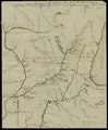 | 743 × 900, 2 страницы (156 КБ) | Fæ | IA Query "subject:maps date:[1000 TO 1869] " ruggles_408 Category:Old maps (COM:IA books#query) (1832 #653) |
Использование файла
Нет страниц, использующих этот файл.