Перейти на страницу файла на Викискладе

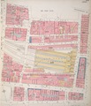
Файл:Insurance Plan of City of London Vol. I; sheet 23 (BL 150118).tiff

Материал из Википедии — свободной энциклопедии
Перейти к навигации Перейти к поиску

Исходный файл(3159 × 3693 пкс, размер файла: 33,38 МБ, MIME-тип: image/tiff)

Краткое описание

Название
Insurance Plan of City of London Vol. I: sheet 23
Описание
English: This detailed 1886 plan of London is one of a series of twenty-five sheets in an atlas originally produced to aid insurance companies in assessing fire risks. The building footprints, their use (commercial, residential, educational, etc.), the number of floors and the height of the building, as well as construction materials (and thus risk of burning) and special fire hazards (chemicals, kilns, ovens) were documented in order to estimate premiums. Names of individual businesses, property lines, and addresses were also often recorded. Together these maps provide a rich historical shapshot of the commercial activity and urban landscape of towns and cities at the time. The British Library holds a comprehensive collection of fire insurance plans produced by the London-based firm Charles E. Goad Ltd. dating back to 1885. These plans were made for most important towns and cities of the British Isles at the scales of 1:480 (1 inch to 40 feet), as well as many foreign towns at 1:600 (1 inch to 50 feet).
Дата
Источник
Catalogue: http://www.bl.uk/onlinegallery/onlineex/firemaps/england/london/itov/mapsu145ubu22u1uf023r.html
Viewer: http://www.bl.uk/onlinegallery/onlineex/firemaps/england/london/itov/zoomify150118.html
Создатель
Chas E Goad Limited
 Geotemporal data
Изображённое время
Map location London and South East
Масштаб Inches [1:480]. 40 ft = 1 inch. and [1:2400]. 200 ft = 1 inch.
Georeferencing Georeference the map in Wikimaps Warper If inappropriate please set warp_status = skip to hide.
 Bibliographic data
Издательство
Chas E Goad Limited
 Archival data
The British Library
Инвентарный номер
Maps 145.b.22.(.1)
Техника Image
Примечания Content-id: 150118


Лицензирование

Public domain

Это произведение находится в общественном достоянии в тех странах, где срок охраны авторского права равен жизни автора плюс 100 лет и менее.


Это произведение находится в общественном достоянии (англ. public domain) в США, так как оно было опубликовано до 1 января 1929 года.

Краткие подписи

Добавьте однострочное описание того, что собой представляет этот файл

Элементы, изображённые на этом файле

изображённый объект

История файла

Нажмите на дату/время, чтобы посмотреть файл, который был загружен в тот момент.

Дата/времяМиниатюраРазмерыУчастникПримечание
текущий18:39, 24 марта 2017Миниатюра для версии от 18:39, 24 марта 20173159 × 3693 (33,38 МБ)British Library Fire insurance maps, #313, http://www.bl.uk/onlinegallery/onlineex/firemaps/england/london/itov/mapsu145ubu22u1uf023r.html

Нет страниц, использующих этот файл.

Глобальное использование файла

Данный файл используется в следующих вики:

Метаданные