Файл:Iwate - Miyako - Taro-Mukaishinden -a- Tsunami height -b- View of damage -c- The survey point where the tsunami runup height of 37,8 m was measured.jpg
Перейти к навигации
Перейти к поиску

Размер этого предпросмотра: 727 × 599 пкс. Другие разрешения: 291 × 240 пкс | 582 × 480 пкс | 932 × 768 пкс | 1242 × 1024 пкс | 2069 × 1706 пкс.
Исходный файл (2069 × 1706 пкс, размер файла: 691 КБ, MIME-тип: image/jpeg)
Этот файл находится на Викискладе. Сведения о нём показаны ниже.
Викисклад — централизованное хранилище для свободных файлов, используемых в проектах Викимедиа.
|
Краткое описание
| Описание |
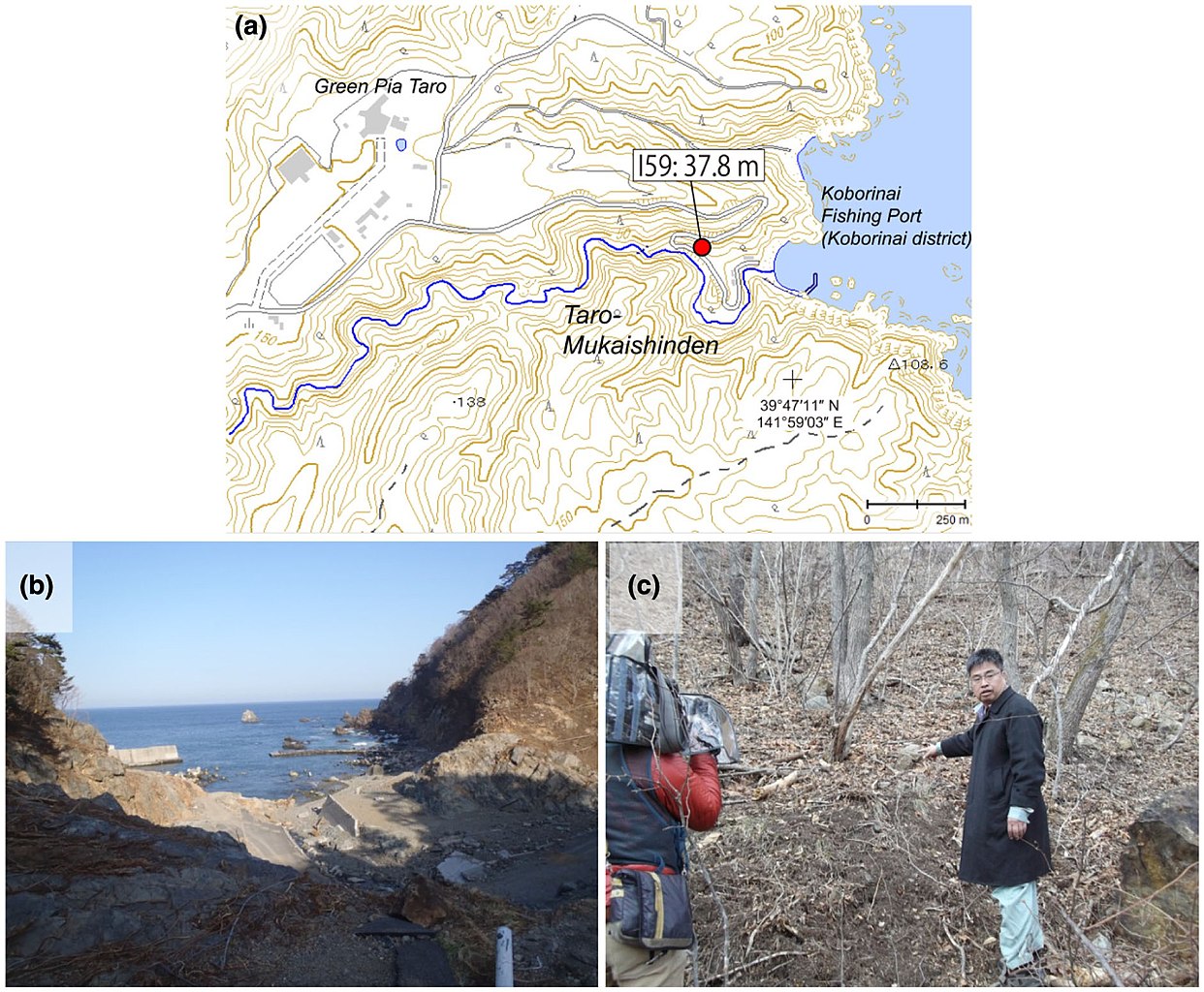
English: Source: Yoshinobu Tsuji, Kenji Satake, Takeo Ishibe, Tomoya Harada, Akihito Nishiyama, Satoshi Kusumoto: "Tsunami Heights along the Pacific Coast of Northern Honshu Recorded from the 2011 Tohoku", Pure and Applied Geophysics, 171, 12, (2014), pp. 3183–3215, DOI:10.1007/s00024-014-0779-x, online published on 19 March 2014. License: Creative Commons Attribution 4.0 International (CC BY 4.0). Here p. 3188, Figure 5.
Caption as given in the above cited source: "Figure 5 - a Tsunami height at Taro-Mukaishinden, Miyako City, Iwate Prefecture. The symbol and its meaning are the same as in Fig. 3. b View of tsunami damage at Taro-Mukaishinden. The white pole in the lower-right of the picture was bent by the tsunami. c The survey point where the largest tsunami runup height of 37.8 m in our field surveys was measured"
|
| Дата | |
| Источник | Yoshinobu Tsuji, Kenji Satake, Takeo Ishibe, Tomoya Harada, Akihito Nishiyama, Satoshi Kusumoto: "Tsunami Heights along the Pacific Coast of Northern Honshu Recorded from the 2011 Tohoku", Pure and Applied Geophysics, 171, 12, (2014), pp. 3183–3215, DOI:10.1007/s00024-014-0779-x, online published on 19 March 2014. License: Creative Commons Attribution 4.0 International (CC BY 4.0). Here p. 3188, Figure 5. |
| Автор | Yoshinobu Tsuji, Kenji Satake, Takeo Ishibe, Tomoya Harada, Akihito Nishiyama, Satoshi Kusumoto: "Tsunami Heights along the Pacific Coast of Northern Honshu Recorded from the 2011 Tohoku", Pure and Applied Geophysics, 171, 12, (2014), pp. 3183–3215, DOI:10.1007/s00024-014-0779-x, online published on 19 March 2014. License: Creative Commons Attribution 4.0 International (CC BY 4.0). Here p. 3188, Figure 5. |
| Права (Повторное использование этого файла) |
Этот файл доступен по лицензии Creative Commons Attribution 4.0 International
|
Лицензирование
Этот файл доступен по лицензии Creative Commons Attribution 4.0 International
- Вы можете свободно:
- делиться произведением – копировать, распространять и передавать данное произведение
- создавать производные – переделывать данное произведение
- При соблюдении следующих условий:
- атрибуция – Вы должны указать авторство, предоставить ссылку на лицензию и указать, внёс ли автор какие-либо изменения. Это можно сделать любым разумным способом, но не создавая впечатление, что лицензиат поддерживает вас или использование вами данного произведения.
История файла
Нажмите на дату/время, чтобы посмотреть файл, который был загружен в тот момент.
| Дата/время | Миниатюра | Размеры | Участник | Примечание | |
|---|---|---|---|---|---|
| текущий | 11:31, 16 августа 2018 | | 2069 × 1706 (691 КБ) | Anglo-Araneophilus~commonswiki | {{Information |description ={{en|1=Source: Yoshinobu Tsuji, Kenji Satake, Takeo Ishibe, Tomoya Harada, Akihito Nishiyama, Satoshi Kusumoto: "Tsunami Heights along the Pacific Coast of Northern Honshu Recorded from the 2011 Tohoku", Pure and Applied Geophysics, 171, 12, (2014), pp. 3183–3215, DOI:10.1007/s00024-014-0779-x, online published on 19 March 2014. License: Creative Commons Attribution 4.0 International (CC BY 4.0). Here p. 3188, Figure 5. Caption as given in the above cited source... |
Использование файла
Нет страниц, использующих этот файл.
Глобальное использование файла
Данный файл используется в следующих вики:
- Использование в de.wikipedia.org