Файл:La deforestación en la frontera domínico-haitiana.tif
Перейти к навигации
Перейти к поиску

Размер этого JPG-превью для исходного TIF-файла: 800 × 600 пкс. Другие разрешения: 320 × 240 пкс | 640 × 480 пкс | 1024 × 768 пкс | 1280 × 960 пкс | 2560 × 1920 пкс.
Исходный файл (2560 × 1920 пкс, размер файла: 11,17 МБ, MIME-тип: image/tiff)
Этот файл находится на Викискладе. Сведения о нём показаны ниже.
Викисклад — централизованное хранилище для свободных файлов, используемых в проектах Викимедиа.
|
Краткое описание
| Описание |
Afrikaans: Hewige ontbossing was tydens die 20ste eeu die norm op die eiland Hispaniola. Die verskynsel het albei nasies op die eiland geraak, maar dit het sy mees kritieke vlak in die Republiek van Haïti bereik. Die probleem het so akuut geword dat Haïtiaanse woudbedekking slegs 2% is, vergeleke met 40% in die Dominikaanse Republiek. Hierdie kontras word duidelik aan die Haïtiaans-Dominikaanse grens gesien, sodat ruimtevaarders die politieke grens tussen hierdie twee lande kan identifiseer net deur waar te neem waar die bosbedekking skielik eindig. Op beeld is die Republiek van Haïti aan die linkerkant en die Dominikaanse Republiek aan die regterkant.
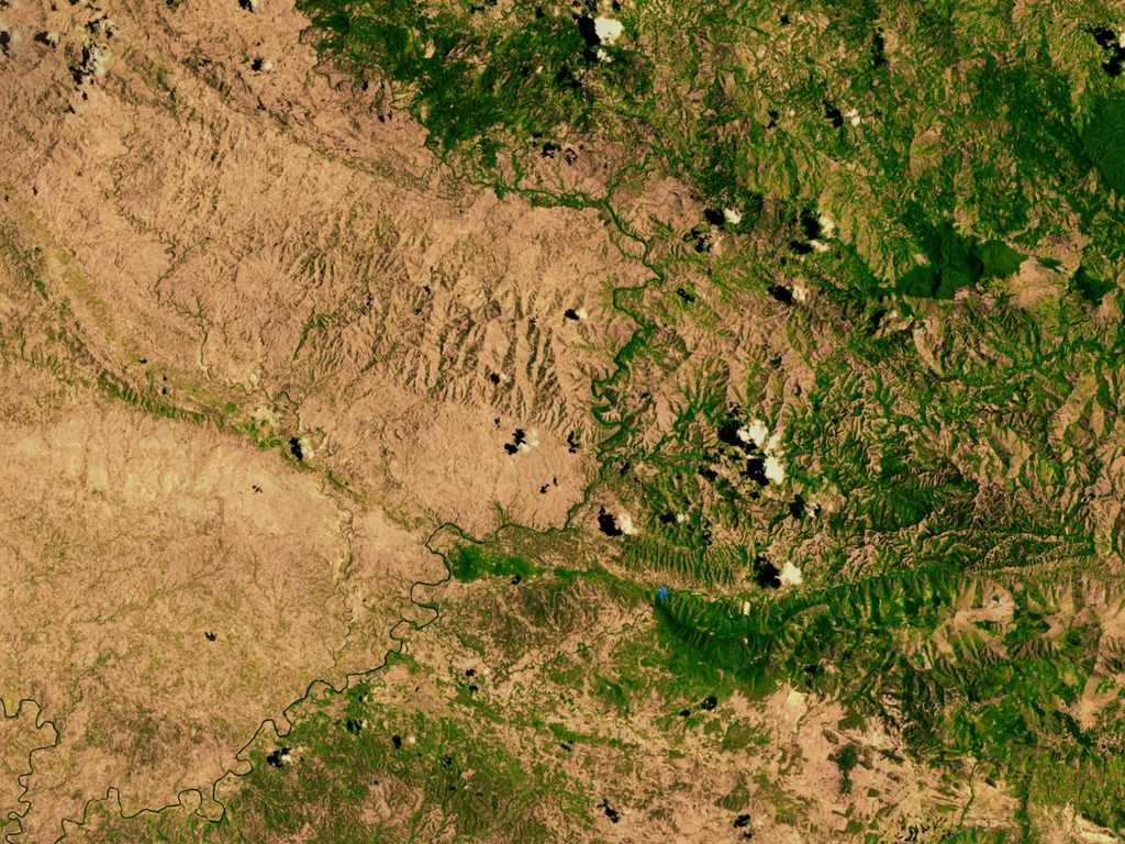
English: The island of Hispaniola has been subject to heavy deforestation during the 20th century. This phenomenon has affected both nations that occupy the island, however it has reached its most critical level in the Republic of Haiti. The problem has become so acute that Haitian forest cover is only 2% compared to 40% in the Dominican Republic. This contrast is clearly seen in the Haitian-Dominican border, such that astronauts can identify the political border between these two countries just by observing where the forest cover ends abruptly. The Republic of Haiti is on the left and the Dominican Republic is on the right.
Español: La Isla de Santo Domingo ha sido sujeta una fuerte deforestación durante el siglo XX. Este fenómeno ha afectado a ambas naciones que ocupan la isla, sin embargo ha llegado a su nivel más crítico en la República de Haití. El problema se ha agudizado tanto, que la cubierta forestal haitiana es de tan solo 2% comparado con el 40% en República Dominicana. Este constraste se nota claramente en la frontera domínico-haitiana con lujos de detalles, que los astronautas pueden identificar la frontera política entre estos dos países con tan solo observar dónde la cobertura boscosa termina abruptamente. La República de Haití en la izquierda y la República Dominicana en la derecha. |
| Дата | |
| Источник | https://svs.gsfc.nasa.gov/vis/a000000/a002600/a002640/ |
| Автор | NASA |
Лицензирование
| Этот файл находится в общественном достоянии (англ. public domain), так как он был создан NASA (Национальным управлением по аэронавтике и исследованию космического пространства). Политика авторского права NASA гласит, что «Материал NASA не защищается авторским правом, если не указано иное». (См. Template:PD-USGov, страницу политики авторского права NASA или политику использования изображений JPL.) | ||
 |
Предупреждения:
|
История файла
Нажмите на дату/время, чтобы посмотреть файл, который был загружен в тот момент.
| Дата/время | Миниатюра | Размеры | Участник | Примечание | |
|---|---|---|---|---|---|
| текущий | 03:02, 10 февраля 2014 |  | 2560 × 1920 (11,17 МБ) | Siso84~commonswiki | User created page with UploadWizard |
Использование файла
Нет страниц, использующих этот файл.
Глобальное использование файла
Данный файл используется в следующих вики:
- Использование в en.wikipedia.org
- Использование в eo.wikipedia.org
- Использование в fr.wikipedia.org
- Использование в ja.wikipedia.org