Файл:Lagoa dos Patos (MODIS 2019-12-02).jpg

Исходный файл (3164 × 2537 пкс, размер файла: 2,26 МБ, MIME-тип: image/jpeg)
Этот файл находится на Викискладе. Сведения о нём показаны ниже.
Викисклад — централизованное хранилище для свободных файлов, используемых в проектах Викимедиа.
|
.jpg?uselang=ru)
Краткое описание
| Описание |
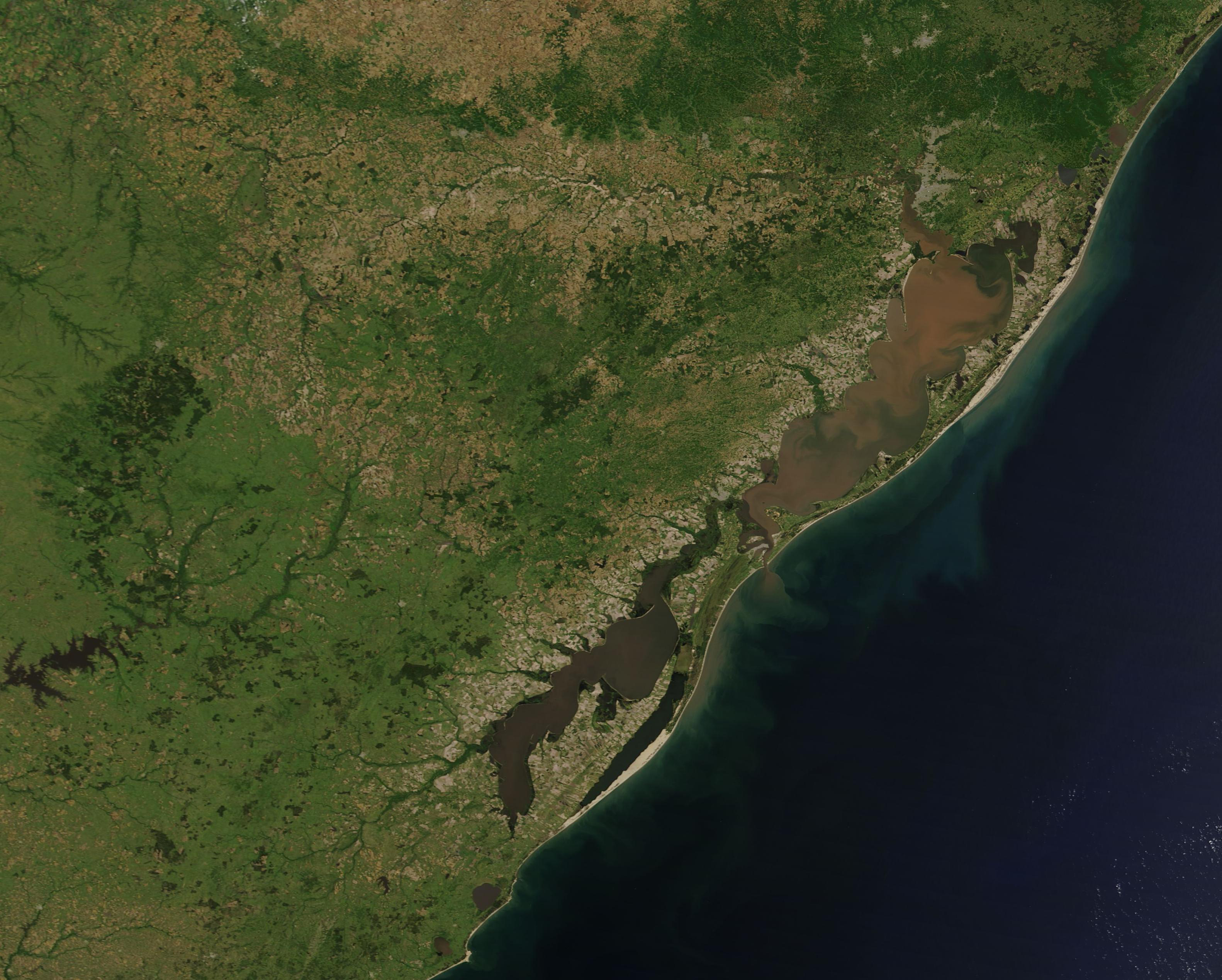
English: The warm, temperate, waters of the Lagoa dos Patos were filled with muddy-tan sediment in late November 2019. NASA’s Terra satellite flew over the region on November 29, allowing the Moderate Resolution Imaging Spectroradiometer (MODIS) on board to acquire a true-color image of the region as Brazil’s dry season comes to a close and the wet season opens.
Located on the southeastern Atlantic coast of Brazil, Lagoa dos Patos (Patos Lagoon) is the world’s largest choked lagoon, measuring covering roughly 10,360 square km (4,000 sq. mi) and stretching 250 km (155 mi) in length. Choked lagoons are a type of lagoon that have a narrow channel to the sea, which significantly obstructs tides from entering and also prevents much mixing of water. Most of the inflow into the lagoon comes from the Jacui-Guaiba and Camaqua Rivers in the northwest. As a result, the about 80% of the lagoon’s waters are fresh or barely saline, but, in the south, the water exchanges with the Atlantic Ocean through an inlet bounded by stable jetties, creating a microtidal estuary. The exact salinity of the waters of Lagoa dos Patos is driven by a combination of the intensity of inflow of fresh water (highest in the wet season floods) and the inflow of ocean water, which is driven by tides and wind. Strong southeast winds are most effective for driving saline water into the lagoon. Lagoa dos Patos is shallow and possesses a bottom densely covered with sediment, both features that allow sediment to swirl in the face of high winds or currents. It is most likely, however, that the majority of the sediment seen in has been carried in from the fresh-water rivers, which drain a watershed of about 200,000 square kilometers (77,220 sq. mi). At its southern end, Lagoa dos Patos shares a narrow connection to the smaller, more open, Lagoa Mirim, which crosses Uruguay’s northern border. |
||
| Дата | Снято: 29 ноября 2019 | ||
| Источник |
|
||
| Автор | MODIS Land Rapid Response Team, NASA GSFC |
| This media is a product of the Terra mission Credit and attribution belongs to the mission team, if not already specified in the "author" row |
Лицензирование
| Этот файл находится в общественном достоянии (англ. public domain), так как он был создан NASA (Национальным управлением по аэронавтике и исследованию космического пространства). Политика авторского права NASA гласит, что «Материал NASA не защищается авторским правом, если не указано иное». (См. Template:PD-USGov, страницу политики авторского права NASA или политику использования изображений JPL.) | ||
 |
Предупреждения:
|
История файла
Нажмите на дату/время, чтобы посмотреть файл, который был загружен в тот момент.
| Дата/время | Миниатюра | Размеры | Участник | Примечание | |
|---|---|---|---|---|---|
| текущий | 02:47, 17 февраля 2024 | | 3164 × 2537 (2,26 МБ) | OptimusPrimeBot | #Spacemedia - Upload of http://modis.gsfc.nasa.gov/gallery/images/image12022019_250m.jpg via Commons:Spacemedia |
Использование файла
Нет страниц, использующих этот файл.
.jpg)