Перейти на страницу файла на Викискладе

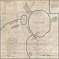
Файл:Lake Manasarovar, Tibet map in French and Persian detail from 1784 Tiefenthaler Map of the Ganges and Ghaghara Rivers, India (cropped).jpg

Материал из Википедии — свободной энциклопедии
Перейти к навигации Перейти к поиску

Исходный файл(1725 × 1727 пкс, размер файла: 848 КБ, MIME-тип: image/jpeg)

Carte Generale du Cours du Gange et du Gagra, dressee sur les Cartes particulieres du P. Tiefentaller, J. Missionnaire Apostolique dans l'Inde.
Автор
Название
Carte Generale du Cours du Gange et du Gagra, dressee sur les Cartes particulieres du P. Tiefentaller, J. Missionnaire Apostolique dans l'Inde.
Описание
English: A rare and remarkable discovery this is Joseph Tiefenthaler and Anquetil-Duperron’s important 1784 map of the Ganges and Ghaghara (Karnali) river system. As a whole this map is a significant advancement over earlier mappings of this region as evidenced in the works of De L’Isle and others. Presented here are actually six maps on a single sheet. The central map (Fig. 1), showing the entire course of the Ganges and the Ghaghara rivers, is a European style map produced by Tiefenthaler based upon his own travels and quadrant surveys as well as on the indigenous cartography he collected along the way. Four of the five smaller maps presented are in fact Tiefenthaler’s copies of Indian maps given to or provided for him. The stylistic difference between these and the central European style map are clear, especially as regarding the rendering of direction, bodies of water, and topography. Tiefenthaler’s copies of indian cartographic material include figures II, III, IV, and V. Figure II correctly locates the source of the Ganges at the Gangotri Glacier, Gaumukah, known as the “Cow’s Mouth” due to its strong resemblance to the open mouth of a cow. Figure III, a large map at the top center, focuses on the Lake of Mansarovar (Mansaroar), the supposed source of the Karnali or Ghaghara River. It is unlikely that Tiefenthaler actually ever say Mansarovar as this lake is located high on the Tibetan Plateau which, during this historic period, was closed to foreigners. Figure IV is another Indian chart focusing on the secondary sources around the volcano of Doulou Bassandar. Figure V shows a secondary source for the Ghaghara as it runs through the Himalayas. Figure VI depicts earlier misconceptions regarding the source of the Ganges as suggested by P. Souciet in his 1729 four volume work Observations, Mathematical, Astronomical, Geographica, Chronological, and Physical . One of the most striking elements of this map is the inclusion of Pesian text in each of the maps Tiefenthaler claims to have copied from indigenous sources. These text blocks are vaguely transliterated and translated into French in a table in the upper left quadrant. The is the only European map of India we are aware of to incorporate Persian text. Most of the cartographic work that led to this map was completed by Tiefenthaler in India. Tiefenthaler, near the end of his life, forwarded it to his friend and fellow orientalist Anquetil-Duperron, living at the time in Paris. Duperron, a noted orientalist, compiled Tiefenthaler’s research and sketches into this important independently issued map. Though significant in its time this map is little known by modern cartographic historians who, when discussing the mapping of India, tend to focus on the later work of Rennell.
Дата 1784 (dated)
Размеры высота: 24 дюймов (60,9 см); ширина: 30 дюймов (76,2 см)
dimensions QS:P2048,24U218593
dimensions QS:P2049,30U218593
Инвентарный номер
Geographicus link: Ganges-teifentaller-1784
Источник/Фотограф
Права
(Повторное использование этого файла)
Это изображение является точной фотографической репродукцией оригинального двумерного произведения изобразительного искусства. Данное произведение изобразительного искусства само по себе находится в общественном достоянии по следующей причине:
Public domain

Это произведение находится в общественном достоянии в тех странах, где срок охраны авторского права равен жизни автора плюс 100 лет и менее.


Вы также должны пометить это произведение одним из шаблонов общественного достояния США, чтобы указать причину, по которой оно находится в статусе общественного достояния в США.
Официальная позиция, занятая «Фондом Викимедиа», заключается в том, что «точные репродукции двумерных произведений изобразительного искусства, находящихся в общественном достоянии, также находятся в общественном достоянии, и заявления об обратном представляют собой нападки на саму концепцию общественного достояния». Для получения подробной информации см. Commons:Когда использовать тег PD-Art.
Эта фотографическая репродукция, следовательно, также считается находящейся в общественном достоянии. Просим учитывать, что в зависимости от местного законодательства повторное использование этого контента может быть запрещено или ограничено в вашей юрисдикции. См. Commons:Когда использовать тег PD-Art.
Другие версии
процесс извлечения
Этот файл был извлечён из другого файла
: 1784 Tiefenthaler Map of the Ganges and Ghaghara Rivers, India - Geographicus - Ganges-teifentaller-1784.jpg
оригинальный файл

Краткие подписи

Добавьте однострочное описание того, что собой представляет этот файл

Элементы, изображённые на этом файле

изображённый объект

История файла

Нажмите на дату/время, чтобы посмотреть файл, который был загружен в тот момент.

Дата/времяМиниатюраРазмерыУчастникПримечание
текущий13:56, 17 апреля 2019Миниатюра для версии от 13:56, 17 апреля 20191725 × 1727 (848 КБ)Tibet NationFile:1784 Tiefenthaler Map of the Ganges and Ghaghara Rivers, India - Geographicus - Ganges-teifentaller-1784.jpg cropped 56 % horizontally, 45 % vertically using CropTool with lossless mode.

Нет страниц, использующих этот файл.

Глобальное использование файла

Данный файл используется в следующих вики: