Файл:Lake Vänern and Lake Vättern (MODIS 2021-09-05).jpg

Исходный файл (2312 × 1882 пкс, размер файла: 560 КБ, MIME-тип: image/jpeg)
Этот файл находится на Викискладе. Сведения о нём показаны ниже.
Викисклад — централизованное хранилище для свободных файлов, используемых в проектах Викимедиа.
|
.jpg?uselang=ru)
Краткое описание
| Описание |
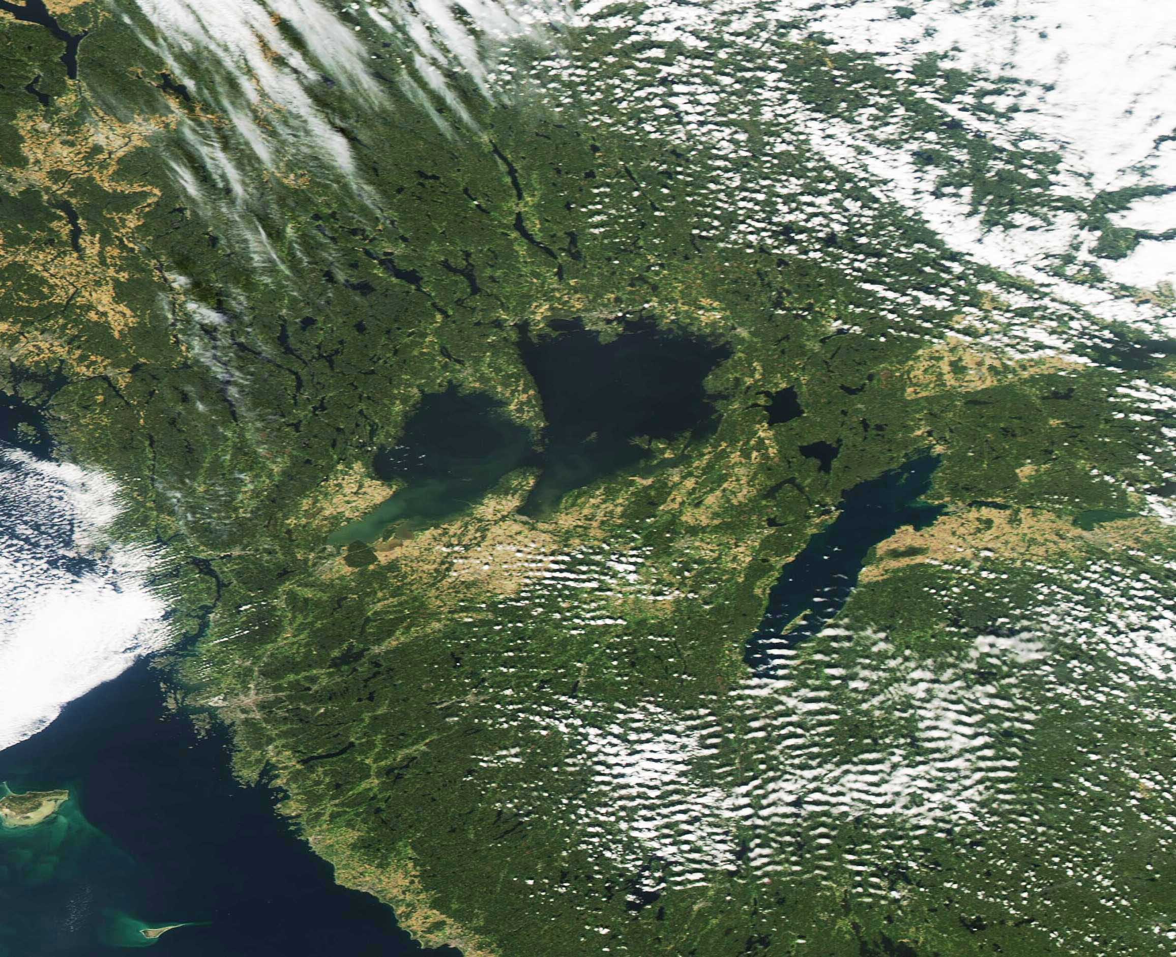
English: Sometime around 10,000 years ago, massive glaciers carved the landscape of what is now Sweden. The slow grinding action of several-mile-thick ice created mountains in the north of the country and, in the south, a flatter landscape with deep depressions—which are now lakes—in the south. The two largest lakes in Sweden, Lake Vänern and Lake Vättern, are two examples of the power of ice over the landscape.
Situated in southwestern Sweden, and with a surface are of about 5,650 square kilometers (2,180 sq mi) Lake Vänern claims the title of the largest lake in Sweden as well as the third-largest lake in Europe. It has a coastline of 4,800 km (2,983 mi), much of which is rocky and wooded, but also hosts several cities and towns that are important as fishing and industrial centers. Within the lake, there is a complex freshwater archipelago containing more than 22,000 islands, islets, and boulders. The largest island, Djuro, is located in the center of the lake and has been named a national park. The longer, thinner, Lake Vättern sits to the southeast of Vänern. With a surface are of 1,912 square km (738 sq mi), Vättern is the second-largest lake in Sweden and the sixth-largest in Europe. It provides drinking water for more than 250.000 people and is a popular destination for those seeking to view or swim in the crystal-clear waters. The Moderate Resolution Imaging Spectroradiometer (MODIS) on board NASA’s Aqua satellite acquired a true-color image of Lake Vänern and Lake Vättern on September 2, 2021. |
||
| Дата | Снято: 2 сентября 2021 | ||
| Источник |
Lake Vänern and Lake Vättern (direct link)
|
||
| Автор | MODIS Land Rapid Response Team, NASA GSFC |
| This media is a product of the Aqua mission Credit and attribution belongs to the mission team, if not already specified in the "author" row |
Лицензирование
| Этот файл находится в общественном достоянии (англ. public domain), так как он был создан NASA (Национальным управлением по аэронавтике и исследованию космического пространства). Политика авторского права NASA гласит, что «Материал NASA не защищается авторским правом, если не указано иное». (См. Template:PD-USGov, страницу политики авторского права NASA или политику использования изображений JPL.) | ||
 |
Предупреждения:
|
История файла
Нажмите на дату/время, чтобы посмотреть файл, который был загружен в тот момент.
| Дата/время | Миниатюра | Размеры | Участник | Примечание | |
|---|---|---|---|---|---|
| текущий | 18:48, 29 января 2024 | | 2312 × 1882 (560 КБ) | OptimusPrimeBot | #Spacemedia - Upload of http://modis.gsfc.nasa.gov/gallery/images/image09052021_250m.jpg via Commons:Spacemedia |
Использование файла
Нет страниц, использующих этот файл.
.jpg)