Файл:Los Angeles River - flood of 1938 near Laurel Canyon Road (SPCOL26).jpg
Los_Angeles_River_-_flood_of_1938_near_Laurel_Canyon_Road_(SPCOL26).jpg (457 × 355 пкс, размер файла: 34 КБ, MIME-тип: image/jpeg)
Этот файл находится на Викискладе. Сведения о нём показаны ниже.
Викисклад — централизованное хранилище для свободных файлов, используемых в проектах Викимедиа.
|
.jpg?uselang=ru)
Краткое описание
| Описание |
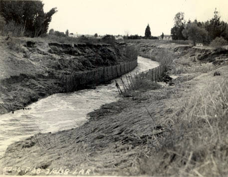
English: Los Angeles River - flood of 1938 near Laurel Canyon Road
Los Angeles River - Looking upstream from Laurel Canyon Avenue, showing wire and pipe protection which withstood the flood successfully. River mile 38.1. This image is from the Report on Engineering Aspects, Flood of March 1938 by the U. S. Engineer Office in Los Angeles and compiled in August 1938. The Los Angeles River and the river's tributaries flooded after a very wet rainy season and one particularly bad storm on March 1-3, 1938. The Report is a part of the Special Collections at CSU, Northridge and gives an extensive account of how different river channels reacted to the flood. After this flood, the Army Corps of Engineers set about insuring extensive flooding would not cause such extreme damage in the future. Image 29 in report. Black and white photograph. 3.5 x 4.5 in. |
| Дата | |
| Источник | http://digital-library.csun.edu/cdm/ref/collection/SFVH/id/3100 |
| Автор | United States. Army. Corps of Engineers. Engineer Office |
| Местоположение камеры | | Это и другие изображения по их местоположению на OpenStreetMap |
|---|
.jpg¶ms=034.147277_N_-118.392791_E_globe:Earth_type:camera__&language=ru)
Лицензирование
Это произведение является работой служащего или сотрудника Инженерных войск США, сделанной или полученной им в ходе исполнения должностных обязанностей. Будучи работой высших федеральных органов государственной власти США, произведение находится в общественном достоянии.
|
История файла
Нажмите на дату/время, чтобы посмотреть файл, который был загружен в тот момент.
| Дата/время | Миниатюра | Размеры | Участник | Примечание | |
|---|---|---|---|---|---|
| текущий | 21:15, 15 июня 2014 | | 457 × 355 (34 КБ) | Junkyardsparkle | {{Information |Description={{en|''Los Angeles River - flood of 1938 near Laurel Canyon Road'' <p>Los Angeles River - Looking upstream from Laurel Canyon Avenue, showing wire and pipe protection wich withstood the flood successfully. River mile 38.1. Th... |
Использование файла
Нет страниц, использующих этот файл.
Глобальное использование файла
Данный файл используется в следующих вики:
- Использование в en.wikipedia.org
.jpg)