Файл:Lower Chute Plan and Section - Bear Trap Dam, State Route 115, Stoddartsville, Luzerne County, PA HAER PA-646 (sheet 3 of 4).tif

Исходный файл (14 438 × 9622 пкс, размер файла: 1,29 МБ, MIME-тип: image/tiff)
Этот файл находится на Викискладе. Сведения о нём показаны ниже.
Викисклад — централизованное хранилище для свободных файлов, используемых в проектах Викимедиа.
|
Краткое описание
| Lower Chute Plan and Section - Bear Trap Dam, State Route 115, Stoddartsville, Luzerne County, PA | ||||
|---|---|---|---|---|
| Фотограф |
Buehner, Timothy A., creator |
|||
| Название |
Lower Chute Plan and Section - Bear Trap Dam, State Route 115, Stoddartsville, Luzerne County, PA |
|||
| Описание |
White, Josiah |
|||
| Изображённое место | Pennsylvania; Luzerne County; Stoddartsville | |||
| Дата | 1986 | |||
| Размеры | 24 x 36 in. (D size) | |||
| Текущее местонахождение |
Library of Congress Prints and Photographs Division Washington, D.C. 20540 USA http://hdl.loc.gov/loc.pnp/pp.print |
|||
| Инвентарный номер |
HAER PA-646 (sheet 3 of 4) |
|||
| Дополнительная информация |
|
|||
| Примечания |
Developed by Josiah White and patented in 1819, the Bear Trap Dam was a hydraulic lock. Water was allowed to flow into the chamber where it was trapped and channeled under the gates, causing the gates to rise and impede the river flow. As the water pooled, loaded wooden arks 85 feet long and 14 feet wide were positioned behind the dam, awaiting passage. When the pool was sufficient, the water in the chamber was released causing the gates to drop and create an artificial freshet which the arks rode downstream to the next lock or dam. At the end of the journey, the arks were dismantled and sold for lumber. The advent of the railroad and the seasonal flooding of the Lehigh River Valley during the mid-1800's brought the demise of slack water navigation and the Bear Trap Dam.
|
|||
| Источник | https://www.loc.gov/pictures/item/pa4124.sheet.00003a | |||
| Права (Повторное использование этого файла) |
|
|||
| Другие версии |
.png) |
|||

| Местоположение объекта | | Это и другие изображения по их местоположению на OpenStreetMap |
|---|
История файла
Нажмите на дату/время, чтобы посмотреть файл, который был загружен в тот момент.
| Дата/время | Миниатюра | Размеры | Участник | Примечание | |
|---|---|---|---|---|---|
| текущий | 09:25, 1 августа 2014 | 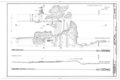 | 14 438 × 9622 (1,29 МБ) | Fæ | GWToolset: Creating mediafile for Fæ. HABS 31 July 2014 (3000:3200) |
Использование файла
Нет страниц, использующих этот файл.