Файл:Madagascar and the Mozambique Channel (MODIS 2020-04-11).jpg
Перейти к навигации
Перейти к поиску

Размер этого предпросмотра: 745 × 600 пкс. Другие разрешения: 298 × 240 пкс | 596 × 480 пкс | 954 × 768 пкс | 1272 × 1024 пкс | 1865 × 1502 пкс.
Исходный файл (1865 × 1502 пкс, размер файла: 263 КБ, MIME-тип: image/jpeg)
Этот файл находится на Викискладе. Сведения о нём показаны ниже.
Викисклад — централизованное хранилище для свободных файлов, используемых в проектах Викимедиа.
|
.jpg?uselang=ru)
Краткое описание
| Описание |
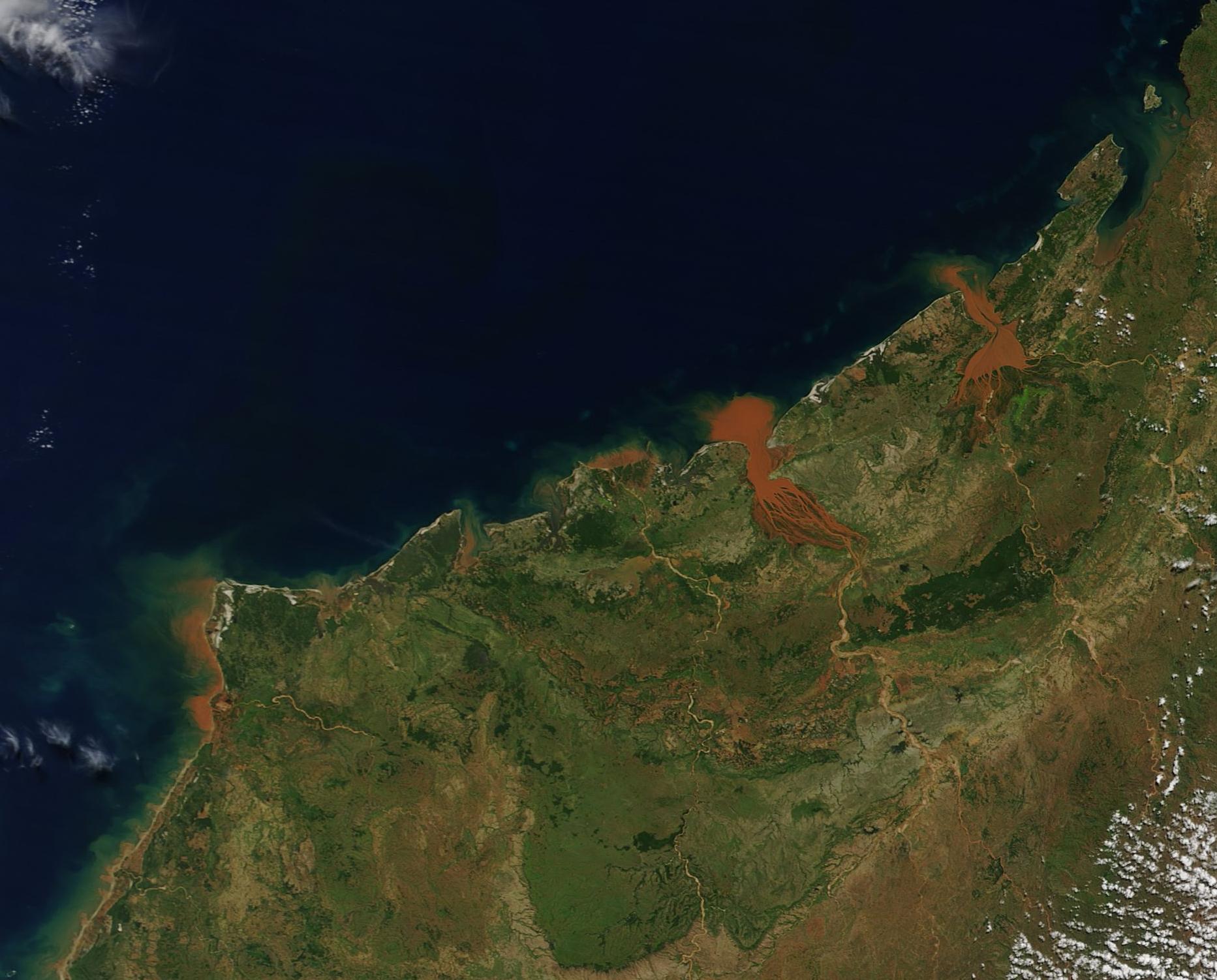
English: On April 10, 2020, the Moderate Resolution Imaging Spectroradiometer (MODIS) on board NASA’s Terra satellite acquired a stunning true-color image of red sediments pouring into the Mozambique Channel from northwestern Madagascar.
The Mozambique Channel separates the island of Madagascar from the southeastern coast of Africa. Bombetoka Bay, the brick-red estuary in the center of the image, is fed by the Betsiboka River. It is easy to see why it is famous for to its striking red floodplain sediments. To its right (northeast) Mahajamba Bay is fed by several rivers, including the Mahajamba and Sofia. Like the Betsiboka, the floodplains of these rivers contain reddish sediments eroded from their basins upstream. Historical maps of Madagascar describe the sandy to clay-rich soils around the Betsiboka River as terres rouges, or “red lands.” (The island was a French territory from 1895 to 1960.) They were describing laterites—soils rich in iron oxides—that form in tropical climates from the chemical breakdown of iron-rich rocks. These soils and sediments lend the river a rusty orange color when the island experiences heavy seasonal rain or downpours from tropical cyclones. The opening months of 2020 have brought heavy rains to northern Madagascar, including a very large flooding event in January. |
||
| Дата | Снято: 10 апреля 2020 | ||
| Источник |
Madagascar and the Mozambique Channel (direct link)
|
||
| Автор | MODIS Land Rapid Response Team, NASA GSFC |
| This media is a product of the Terra mission Credit and attribution belongs to the mission team, if not already specified in the "author" row |
Лицензирование
| Этот файл находится в общественном достоянии (англ. public domain), так как он был создан NASA (Национальным управлением по аэронавтике и исследованию космического пространства). Политика авторского права NASA гласит, что «Материал NASA не защищается авторским правом, если не указано иное». (См. Template:PD-USGov, страницу политики авторского права NASA или политику использования изображений JPL.) | ||
 |
Предупреждения:
|
История файла
Нажмите на дату/время, чтобы посмотреть файл, который был загружен в тот момент.
| Дата/время | Миниатюра | Размеры | Участник | Примечание | |
|---|---|---|---|---|---|
| текущий | 03:11, 17 февраля 2024 | | 1865 × 1502 (263 КБ) | OptimusPrimeBot | #Spacemedia - Upload of http://modis.gsfc.nasa.gov/gallery/images/image04112020_250m.jpg via Commons:Spacemedia |
Использование файла
Нет страниц, использующих этот файл.
.jpg)