Файл:Muruntau Au mine 2022.jpg
Muruntau_Au_mine_2022.jpg (720 × 480 пкс, размер файла: 137 КБ, MIME-тип: image/jpeg)
Этот файл находится на Викискладе. Сведения о нём показаны ниже.
Викисклад — централизованное хранилище для свободных файлов, используемых в проектах Викимедиа.
|
Краткое описание
| Описание |
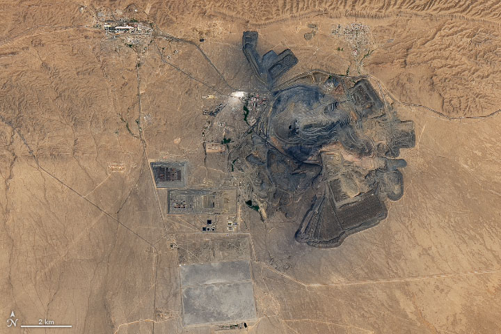
Muruntau Gold Mine from space. In satellite images of central Uzbekistan, a large circular cavity stands out amidst fields of sand and dusty plains. It is Muruntau gold mine, one of the world’s largest sources of gold. On July 22, 2022, the Operational Land Imager (OLI) on Landsat 8 acquired this natural-color image of the mine. Hundreds of trucks and a conveyor system are used to transport ore to nearby processing facilities. Workers then use a process called heap leaching to extract gold and other precious metals. The mine taps into the Muruntau gold deposit, thought to be one of the largest single gold deposits on Earth. The deposit was discovered in 1958, and mining began in 1967. The pit is now 3.5 kilometers (1.8 miles) wide and 600 meters (2,000 feet) deep. In 2021, the mine produced as much as 3 million ounces (85,000 kilograms) of gold. According to geologists, gold is near the surface in this area due to a chain of events that spanned many millions of years. Among them: the closure of an ancient ocean, a period of mountain building, intrusions of granite and water into key rock formations, and the onset of movement along nearby faults. NASA Earth Observatory image by Joshua Stevens, using Landsat data from the U.S. Geological Survey. Story by Adam Voiland. |
|||||
| Дата | July 22, 2022 | |||||
| Источник | https://earthobservatory.nasa.gov/images/150159/muruntau-gold-mine | |||||
| Автор | NASA Earth Observatory | |||||
| Права (Повторное использование этого файла) |
|

История файла
Нажмите на дату/время, чтобы посмотреть файл, который был загружен в тот момент.
| Дата/время | Миниатюра | Размеры | Участник | Примечание | |
|---|---|---|---|---|---|
| текущий | 18:17, 18 августа 2022 | | 720 × 480 (137 КБ) | Tillman | {{Information |Description=Muruntau Gold Mine from space. In satellite images of central Uzbekistan, a large circular cavity stands out amidst fields of sand and dusty plains. It is Muruntau gold mine, one of the world’s largest sources of gold. On July 22, 2022, the Operational Land Imager (OLI) on Landsat 8 acquired this natural-color image of the mine. Hundreds of trucks and a conveyor system are used to transport ore to nearby processing facilities. Workers then use a process called heap... |
Использование файла
Нет страниц, использующих этот файл.
Глобальное использование файла
Данный файл используется в следующих вики:
- Использование в en.wikipedia.org