Файл:North and East Elevations - Dublin Plantation, Main House, 3135 Cottonwood Creek Road, Kingsbury, Guadalupe County, TX HABS TX-304-A (sheet 4 of 9).tif
Перейти к навигации
Перейти к поиску

Размер этого JPG-превью для исходного TIF-файла: 800 × 528 пкс. Другие разрешения: 320 × 211 пкс | 640 × 422 пкс | 1024 × 676 пкс | 1280 × 845 пкс | 2560 × 1689 пкс | 14 404 × 9504 пкс.
Исходный файл (14 404 × 9504 пкс, размер файла: 732 КБ, MIME-тип: image/tiff)
Этот файл находится на Викискладе. Сведения о нём показаны ниже.
Викисклад — централизованное хранилище для свободных файлов, используемых в проектах Викимедиа.
|
Краткое описание
| Внимание! | Изображение содержит очень большое количество пикселей, и при просмотре его в полном разрешении в некоторых обозревателях могут возникнуть такие проблемы, как загрузка искажённого изображения или зависание. |
|---|
| North and East Elevations - Dublin Plantation, Main House, 3135 Cottonwood Creek Road, Kingsbury, Guadalupe County, TX | ||||
|---|---|---|---|---|
| Фотограф |
Related names:
|
|||
| Название |
North and East Elevations - Dublin Plantation, Main House, 3135 Cottonwood Creek Road, Kingsbury, Guadalupe County, TX |
|||
| Описание |
Francis, Sidney J, II, sponsor; Ahumada, Luis D., field team; Brackett, Whitfield R., delineator; Cloudt, Clare E., delineator; Davidson, Brett N., field team; De La Cruz, Analay, field team; Griego, Herminio, field team; Kraft, David J., field team; Lindsay, Jason B., field team; Mcqueen, Aleksandra, field team; Schenck, William C. (Beau), delineator; Xu, Zhao, field team; Ziga, Felix J., field team; Pemberton, Sue Ann, FAIA, faculty sponsor |
|||
| Изображённое место | Texas; Guadalupe County; Kingsbury | |||
| Дата | Documentation compiled after 1933 | |||
| Размеры | 24 x 36 in. (D size) | |||
| Текущее местонахождение |
Library of Congress Prints and Photographs Division Washington, D.C. 20540 USA http://hdl.loc.gov/loc.pnp/pp.print |
|||
| Инвентарный номер |
HABS TX-304-A (sheet 4 of 9) |
|||
| Дополнительная информация |
|
|||
| Примечания |
|
|||
| Источник | https://www.loc.gov/pictures/item/tx1171.sheet.00004a | |||
| Права (Повторное использование этого файла) |
|
|||
| Другие версии |
.png) .png) .png) .png) |
|||

| Местоположение объекта | | Это и другие изображения по их местоположению на OpenStreetMap |
|---|
История файла
Нажмите на дату/время, чтобы посмотреть файл, который был загружен в тот момент.
| Дата/время | Миниатюра | Размеры | Участник | Примечание | |
|---|---|---|---|---|---|
| текущий | 23:04, 3 августа 2014 | 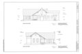 | 14 404 × 9504 (732 КБ) | Fæ | GWToolset: Creating mediafile for Fæ. HABS 2014-08-02 (3401:3600) |
Использование файла
Нет страниц, использующих этот файл.