Файл:Petermann Glacier with Crack September 2008 (Detail) - Flickr - NASA Goddard Photo and Video.jpg
Исходный файл (540 × 672 пкс, размер файла: 410 КБ, MIME-тип: image/jpeg)
Этот файл находится на Викискладе. Сведения о нём показаны ниже.
Викисклад — централизованное хранилище для свободных файлов, используемых в проектах Викимедиа.
|
_-_Flickr_-_NASA_Goddard_Photo_and_Video.jpg?uselang=ru)
Краткое описание
| Описание |
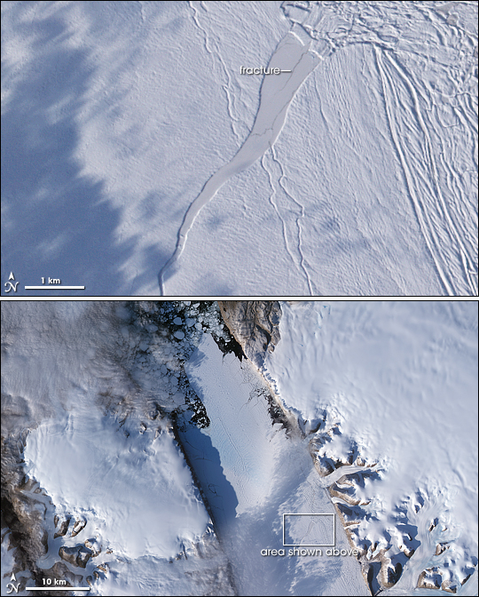
NASA image acquired September 7, 2008. NASA image released September 12, 2008. To view the high res go here: www.flickr.com/photos/gsfc/4872775772 To view a video go here: www.flickr.com/photos/gsfc/4872781732 Covering some 1,295 square kilometers (500 square miles) along the northwestern coast of Greenland, Petermann Glacier’s floating ice tongue is the Northern Hemisphere’s largest, and it has occasionally calved large icebergs. Between 2000 and 2001, the glacier lost nearly 87 square kilometers (34 square miles). Between July 10 and July 24, 2008, the glacier lost another 29 square kilometers (11 square miles). Researchers at the Byrd Polar Research Center at Ohio State University, however, expressed greater concern at the presence of a rift farther upstream. The Advanced Spaceborne Thermal Emission and Reflection Radiometer (ASTER) on NASA’s Terra satellite captured this image of the rift on the Petermann Glacier on September 7, 2008. The rift, which appeared by 2001, is filled with thin ice and covered with snow in the close-up image (top). A thin fracture near the edge of the rift, however, indicates that it has continued to widen. After its initial formation, the rift on Petermann Glacier advanced toward the glacier front, widening as it moved. Satellite images from the 1990s show that rifts have developed in this region on the Petermann more than once, but previous rifts evolved differently than this one, which grew wider and longer. Byrd Polar Research Center scientists stated that if this rift extended completely across the glacier, the glacier could lose another 160 square kilometers (60 square miles)—one third of its current length. The larger view (bottom) shows areas of open water along the glacier’s margins, and a profusion of ice fragments beyond the tip of the glacier tongue. As a glacier squeezes past the fjord walls, the interaction of the ice and rock produces backstress that keeps the ice relatively compressed. But as pieces of ice break away from the glacier, the backstress is reduced, and the glacier begins to stretch. The rift on this glacier is evidence of the glacier’s stretching and thinning over time. NASA images and animation created by Jesse Allen, using data provided courtesy of NASA/GSFC/METI/ERSDAC/JAROS, and U.S./Japan ASTER Science Team. Caption by Michon Scott. Instrument: Terra - ASTER To view more images of the Petermann Glacier go to: earthobservatory.nasa.gov/IOTD/view.php?id=9085 NASA Goddard Space Flight Center is home to the nation's largest organization of combined scientists, engineers and technologists that build spacecraft, instruments and new technology to study the Earth, the sun, our solar system, and the universe. Follow us on Twitter Join us on Facebook'''' |
| Дата | |
| Источник | Petermann Glacier with Crack September 2008 [Detail] |
| Автор | NASA Goddard Space Flight Center from Greenbelt, MD, USA |
Лицензирование
- Вы можете свободно:
- делиться произведением – копировать, распространять и передавать данное произведение
- создавать производные – переделывать данное произведение
- При соблюдении следующих условий:
- атрибуция – Вы должны указать авторство, предоставить ссылку на лицензию и указать, внёс ли автор какие-либо изменения. Это можно сделать любым разумным способом, но не создавая впечатление, что лицензиат поддерживает вас или использование вами данного произведения.
| Это изображение, изначально опубликованное на Flickr, было досмотрено 17 августа 2012 администратором или доверенным пользователем Materialscientist, который подтвердил, что на тот момент оно было доступно на Flickr на условиях указанной лицензии. |
| Этот файл находится в общественном достоянии (англ. public domain), так как он был создан NASA (Национальным управлением по аэронавтике и исследованию космического пространства). Политика авторского права NASA гласит, что «Материал NASA не защищается авторским правом, если не указано иное». (См. Template:PD-USGov, страницу политики авторского права NASA или политику использования изображений JPL.) | ||
 |
Предупреждения:
|
История файла
Нажмите на дату/время, чтобы посмотреть файл, который был загружен в тот момент.
| Дата/время | Миниатюра | Размеры | Участник | Примечание | |
|---|---|---|---|---|---|
| текущий | 21:02, 17 августа 2012 | | 540 × 672 (410 КБ) | Werieth | == {{int:filedesc}} == {{Information |Description=NASA image acquired September 7, 2008. NASA image released September 12, 2008. To view the high res go here: [http://www.flickr.com/photos/gsfc/4872775772 www.flickr.com/photos/gsfc/4872775772] To vi... |
Использование файла
Нет страниц, использующих этот файл.
_-_Flickr_-_NASA_Goddard_Photo_and_Video.jpg)