Файл:Quartzite (roadcut west of Vandola, Virginia, USA) 2 (51724960071).jpg
Исходный файл (4288 × 2848 пкс, размер файла: 7,54 МБ, MIME-тип: image/jpeg)
Этот файл находится на Викискладе. Сведения о нём показаны ниже.
Викисклад — централизованное хранилище для свободных файлов, используемых в проектах Викимедиа.
|
_2_(51724960071).jpg?uselang=ru)
Краткое описание
| Описание |
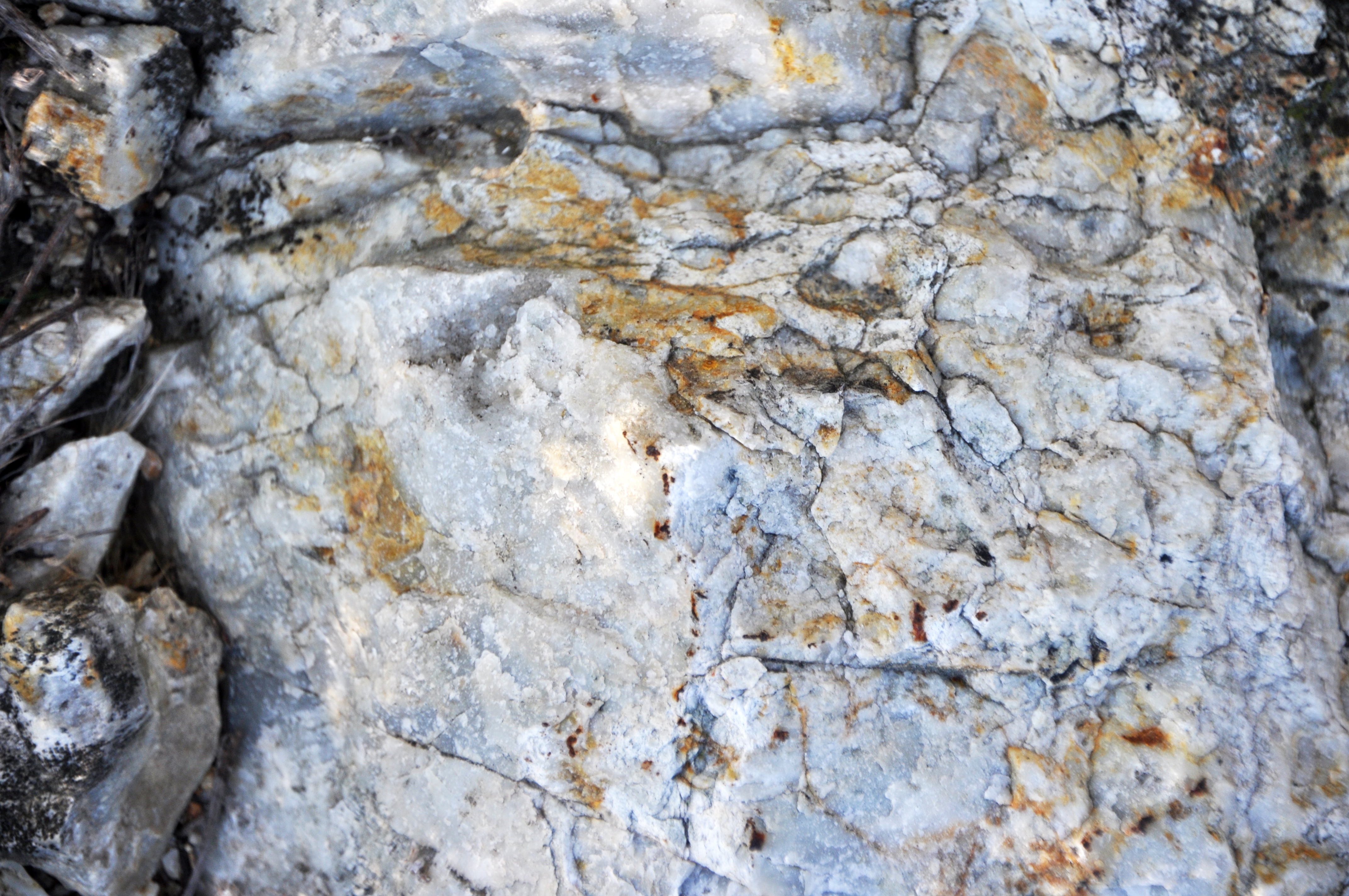
Quartzite is a common, crystalline-textured, intermediate- to high-grade metamorphic rock. It forms by metamorphism of quartzose sandstones or siltstones. Quartzite can be entirely composed of interlocking quartz crystals, or the original sand grains may still be visible. This rock is hard (H = 7), will not bubble in acid (unlike marble), and can be almost any color. The term “quartzite” has been used in geology to refer to crystalline, quartzose metamorphic rocks and to hard, well-cemented quartzose sandstones that have not been subjected to metamorphism. It is difficult to not call hard, well-cemented sandstones “quartzite” - for example, the Clinch Quartzite in the Appalachian Mountains and the Eureka Quartzite of the Great Basin in western USA, but the Clinch and Eureka aren’t metamorphic rocks. The term "metaquartzite" has been used by some geologists to refer to crystalline-textured, quartzose rocks that have been metamorphosed. This implies that “quartzite” be restricted to well-cemented, non-metamorphosed sandstones. I don’t often see the term metaquartzite in the geologic literature. The whitish quartzites seen here (interpreted as part of a metavolcanic unit) are Piedmont metamorphic basement rocks in Virginia. They are exposed in the footwall almost adjacent to a half-graben's eastern boundary fault, a normal fault (= obscured by vegetation at this locality). The hanging wall (a little north of this spot) consists of siliciclastic sedimentary rocks representing Triassic rift basin fill. The half-graben is the Danville Basin (Dan River Basin). Locality: Oak Ridge Farms Road Exit Ramp Outcrop - roadcut along both sides of north-bound exit ramp off Route 58, just west of the town of Vandola & west of Danville, southern Pittsylvania County, southern Virginia, USA (36° 34’ 30.09” North latitude, 79° 31’ 20.13” West longitude) |
| Дата | |
| Источник | Quartzite (roadcut west of Vandola, Virginia, USA) 2 |
| Автор | James St. John |
Лицензирование
- Вы можете свободно:
- делиться произведением – копировать, распространять и передавать данное произведение
- создавать производные – переделывать данное произведение
- При соблюдении следующих условий:
- атрибуция – Вы должны указать авторство, предоставить ссылку на лицензию и указать, внёс ли автор какие-либо изменения. Это можно сделать любым разумным способом, но не создавая впечатление, что лицензиат поддерживает вас или использование вами данного произведения.
| Это изображение изначально опубликовано на Flickr участником проекта James St. John по ссылке https://flickr.com/photos/47445767@N05/51724960071. Оно было досмотрено 19 января 2022 роботом FlickreviewR 2, который подтвердил, что изображение лицензировано в соответствии с условиями cc-by-2.0. |
История файла
Нажмите на дату/время, чтобы посмотреть файл, который был загружен в тот момент.
| Дата/время | Миниатюра | Размеры | Участник | Примечание | |
|---|---|---|---|---|---|
| текущий | 22:00, 19 января 2022 | | 4288 × 2848 (7,54 МБ) | SeichanGant | Transferred from Flickr via #flickr2commons |
Использование файла
Нет страниц, использующих этот файл.
_2_(51724960071).jpg)