Файл:Research on Iceberg B-15A by Josh Landis, National Science Foundation (Image 4) (NSF).jpg

Исходный файл (1995 × 1304 пкс, размер файла: 1,35 МБ, MIME-тип: image/jpeg)
Этот файл находится на Викискладе. Сведения о нём показаны ниже.
Викисклад — централизованное хранилище для свободных файлов, используемых в проектах Викимедиа.
|
_(NSF).jpg?uselang=ru)
Краткое описание
| Описание |
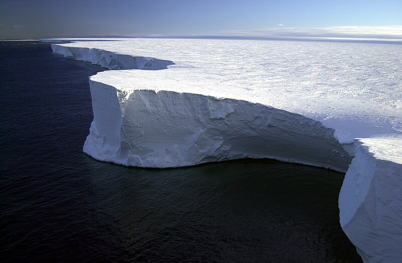
English: The northern edge of the giant iceberg, B-15A, in the Ross Sea, Antarctica.
Iceberg B-15A is a fragment of a much larger iceberg (B-15) that broke away from the Ross Ice Shelf in March 2000. Scientists believe that the enormous piece of ice broke away as part of a long-term natural cycle (every 50-to-100 years, or so) in which the shelf--which is roughly the size of Texas--sheds pieces much as human fingernails grow and break off. Researchers have placed global positioning systems (GPS), weather monitoring stations and four seismometers on different icebergs to track them. The goal is to learn more about what causes icebergs to calve, how and why they drift, what happens when the icebergs warm, and why they are producing previously unknown tremors that are picked up on seismometers as far away as Tahiti. Plans are to track B-15A until it disintegrates. [Iceberg Update: In 2005 prevailing currents took B-15A slowly past the Drygalski ice tongue (an iceberg located in northern McMurdo Sound); the collision broke off the tip of Drygalski in mid-April. Iceberg B-15A sailed on along the coast leaving McMurdo Sound until it ran aground off Cape Adare in Victoria Land (a region of Antarctica lying south of New Zealand), where it broke into several smaller pieces on Oct. 27 and 28, 2005. The largest piece is still named B-15A (its surface is now approx. 1,700 square kilometres), while three additional pieces were named B-15P, B-15M and B-15N. It has since moved farther up north and broken up into more pieces. These were spotted by air force fisheries patrol on Nov. 3, 2006. On November 21, several large pieces were seen just 60 kilometres (37 mi) off the coast of Timaru, New Zealand, the largest measuring about 1.8 kilometres (1.1 mi) wide and 120 feet (37 m) high.] |
| Дата | |
| Источник | http://photolibrary.usap.gov/Portscripts/PortWeb.dll?query&field1=Filename&op1=matches&value=EDGE02.JPG&catalog=Antarctica&template=USAPgovMidThumbs |
| Автор | NSF/Josh Landis, employee 1999-2001 |
| Другие версии |
Лицензирование
| This image is a work of a National Science Foundation employee, taken or made as part of that person's official duties. As a work of the U.S. federal government, the image is in the public domain. |  |
История файла
Нажмите на дату/время, чтобы посмотреть файл, который был загружен в тот момент.
| Дата/время | Миниатюра | Размеры | Участник | Примечание | |
|---|---|---|---|---|---|
| текущий | 00:12, 11 сентября 2007 | | 1995 × 1304 (1,35 МБ) | Flickr upload bot | Uploaded from http://flickr.com/photo/39735679@N00/435955203 using User:Flickr upload bot |
Использование файла
Нет страниц, использующих этот файл.
Глобальное использование файла
Данный файл используется в следующих вики:
- Использование в de.wikipedia.org
- Использование в en.wikipedia.org
- Использование в en.wikivoyage.org
- Использование в es.wikipedia.org
- Использование в fa.wikipedia.org
- Использование в fr.wikipedia.org
- Использование в he.wikipedia.org
- Использование в hy.wikipedia.org
- Использование в id.wikipedia.org
- Использование в ja.wikipedia.org
- Использование в ko.wikipedia.org
- Использование в lt.wikipedia.org
- Использование в nl.wikipedia.org
- Использование в nn.wikipedia.org
- Использование в pl.wikipedia.org
- Использование в pt.wikipedia.org
- Использование в sr.wikipedia.org
- Использование в th.wikipedia.org
- Использование в uk.wikipedia.org
- Использование в www.wikidata.org
- Использование в zh.wikipedia.org
_(NSF).jpg)