Файл:STS007-03-0058.jpg
Перейти к навигации
Перейти к поиску

Размер этого предпросмотра: 593 × 599 пкс. Другие разрешения: 238 × 240 пкс | 475 × 480 пкс | 760 × 768 пкс | 1014 × 1024 пкс | 2027 × 2048 пкс | 5266 × 5320 пкс.
Исходный файл (5266 × 5320 пкс, размер файла: 13,31 МБ, MIME-тип: image/jpeg)
Этот файл находится на Викискладе. Сведения о нём показаны ниже.
Викисклад — централизованное хранилище для свободных файлов, используемых в проектах Викимедиа.
|
Краткое описание
| Описание |
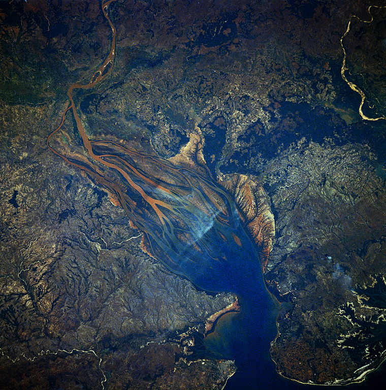
English: STS007-03-0058 Betsiboka River Delta, Madagascar June 1983 Dramatic evidence of the catastrophic erosion of northwestern Madagascar is revealed in this near-vertical, June 1983 photograph of the rapidly expanding Betsiboka River Delta. The removal of the native forest for cultivation and pastureland during the past 50 years has led to massive annual soil losses approaching 112 tons per acre (250 metric tons per hectare) in some regions of the island, the largest amount recorded anywhere in the world. The photograph provides convincing evidence of the result of this process, as the effects of water erosion are seen throughout the 1544-square-mile (4000-square-kilometer) land surface area of the photograph. The delta continues to build toward the mouth of Bombetoka Bay, which enters the Mozambique Channel. |
| Дата | |
| Источник | http://spaceflight.nasa.gov/gallery/ |
| Автор | NASA |
Лицензирование
| Этот файл находится в общественном достоянии (англ. public domain), так как он был создан NASA (Национальным управлением по аэронавтике и исследованию космического пространства). Политика авторского права NASA гласит, что «Материал NASA не защищается авторским правом, если не указано иное». (См. Template:PD-USGov, страницу политики авторского права NASA или политику использования изображений JPL.) | ||
 |
Предупреждения:
|
История файла
Нажмите на дату/время, чтобы посмотреть файл, который был загружен в тот момент.
| Дата/время | Миниатюра | Размеры | Участник | Примечание | |
|---|---|---|---|---|---|
| текущий | 08:30, 21 июня 2013 | | 5266 × 5320 (13,31 МБ) | Askeuhd | User created page with UploadWizard |
Использование файла
Нет страниц, использующих этот файл.