Файл:Smoke cloud over the Davis Strait (Copernicus).jpg
Исходный файл (3827 × 2567 пкс, размер файла: 2,92 МБ, MIME-тип: image/jpeg)
Этот файл находится на Викискладе. Сведения о нём показаны ниже.
Викисклад — централизованное хранилище для свободных файлов, используемых в проектах Викимедиа.
|
.jpg?uselang=ru)
Краткое описание
| Описание |
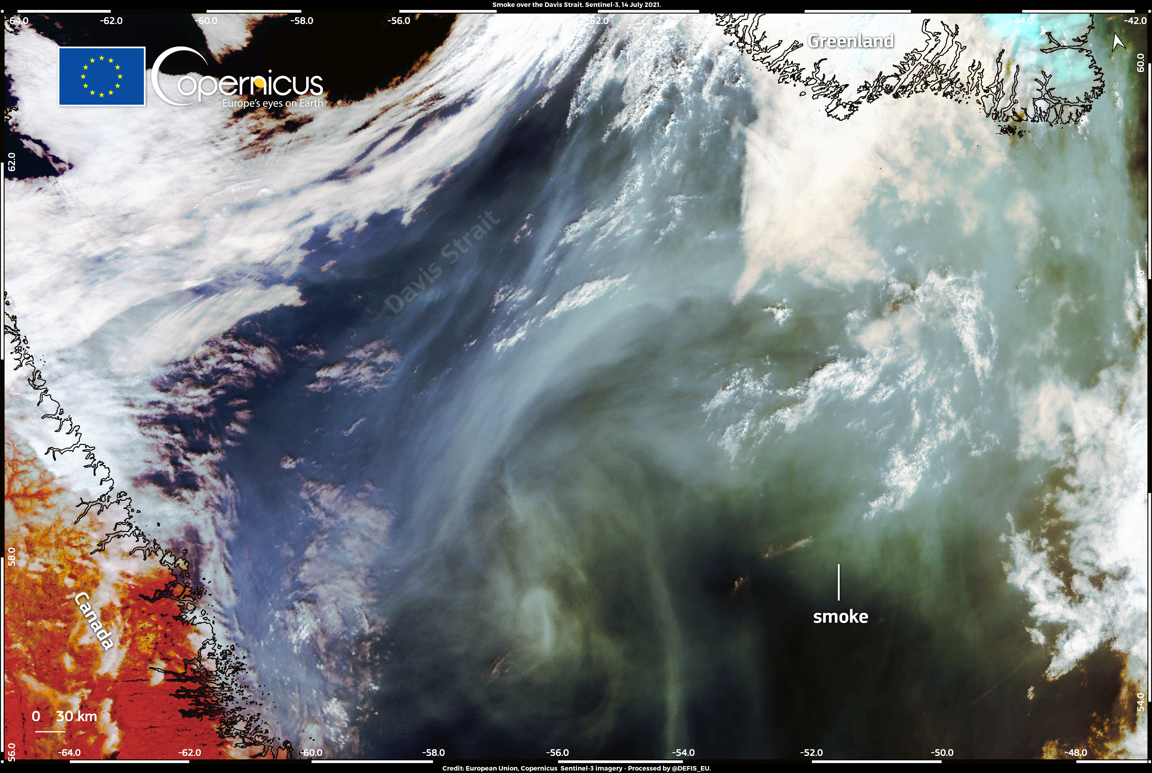
English: This image, acquired by one of the Copernicus Sentinel-3 satellites on 14 July 2021, shows the smoke cloud from North American wildfires covering part of the Davis Strait. As the image shows, the smoke generated by the hundreds of wildfires that are raging in Canada and the United States has travelled thousands of kilometres in just a few days. At 14:11 UTC on 14 July it had reached the west coast of Greenland. According to the Copernicus Atmosphere Monitoring Service (CAMS) forecasts, the smoke will continue to travel eastwards over the next few days and should reach the coast of Norway between 17 and 18 July. Data from Copernicus services provide forecasts on air quality updated every four hours for the whole world. |
| Дата | Снято: 14 июля 2021 |
| Источник | Smoke cloud over the Davis Strait |
| Автор | European Union, Copernicus Sentinel-3 Imagery |
Лицензирование

|
This image contains data from a satellite in the Copernicus Programme, such as Sentinel-1, Sentinel-2 or Sentinel-3. Attribution is required when using this image.
Атрибуция: Contains modified Copernicus Sentinel data 2021
The use of Copernicus Sentinel Data is regulated under EU law (Commission Delegated Regulation (EU) No 1159/2013 and Regulation (EU) No 377/2014). Relevant excerpts:
Free access shall be given to GMES dedicated data [...] made available through GMES dissemination platforms [...].
Access to GMES dedicated data [...] shall be given for the purpose of the following use in so far as it is lawful:
GMES dedicated data [...] may be used worldwide without limitations in time.
GMES dedicated data and GMES service information are provided to users without any express or implied warranty, including as regards quality and suitability for any purpose. |
История файла
Нажмите на дату/время, чтобы посмотреть файл, который был загружен в тот момент.
| Дата/время | Миниатюра | Размеры | Участник | Примечание | |
|---|---|---|---|---|---|
| текущий | 14:27, 9 сентября 2023 | | 3827 × 2567 (2,92 МБ) | OptimusPrimeBot | #Spacemedia - Upload of https://www.copernicus.eu/system/files/2021-07/image_day/20210715_SmokeDavisStrait.jpg via Commons:Spacemedia |
Использование файла
Нет страниц, использующих этот файл.
.jpg)