Файл:Southeastern Europe, late 9th century.jpg
Перейти к навигации
Перейти к поиску
Нет версии с бо́льшим разрешением.
Southeastern_Europe,_late_9th_century.jpg (602 × 429 пкс, размер файла: 365 КБ, MIME-тип: image/jpeg)
Этот файл находится на Викискладе. Сведения о нём показаны ниже.
Викисклад — централизованное хранилище для свободных файлов, используемых в проектах Викимедиа.
|
Краткое описание
| Описание |
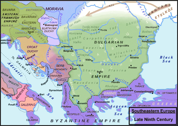
English: Southeastern Europe, late 9th century. |
||
| Дата | |||
| Источник |
Slavistic map, derivative from File:Balkan_9_vek.png enriched with the religious minorities & corrected following: [1]; [2]; Dragan Veselinov Manchov's works (1834-1908) synthetised here: File:Bulgaria-Iván_Asen-es.svg and [3]; Roman Kovalev, (ed.), The Other Europe in the Middle Ages: Avars, Bulgars, Khazars and Cumans, Brill, pp. 151–236. ISBN 978-90-04-16389-8; H.-E. Stier (dir.) Westermann grosser Atlas zur Weltgeschichte, Braunschweig 1985, ISBN 3-14-100919-8, pp. 64, 65, 70 & 88; Francis Conte, Les Slaves, coll. Bibliothèque de l'Évolution de l'Humanité, Albin Michel, 1996, p. 91-96; P. M. Barford, The Early Slavs. Culture and Society in Early Medieval Eastern Europe, ISBN 0-8014-3977-9; John Fine, Jr., The Early Medieval Balkans, ISBN 0 472 081497; Jean W. Sedlar, East Central Europe in the Middle Ages, 1000–1500, University of Washington Press, 2011 ISBN 0-295-97291-2; D. Hupchik, The Balkans. From Constantinople to Communism; Ian Mladjov, “Trans‐Danubian Bulgaria: Reality and Fiction“, in Byzantine Studies n.s. 3, 1998 [2000], 85–128;; Victor Spinei, The Romanians and the Turkic Nomads North of the Danube Delta from the Tenth to the Mid-Thirteenth century, Koninklijke Brill 2009, ISBN 978-90-04-17536-5. |
||
| Автор | Moodylo333 | ||
| Права (Повторное использование этого файла) |
|
||
| Другие версии | File:Balkan_9_vek.png, according with the Hungarian point of view, where the Slavic principality of Blatnograd is confused with the antic Pannonia, the river Dniester is confused with the Prut river, the Aegean islands are already Genoese five centuries in advance, and the "Bulgarian lands across the Danube" (on the northern side) are minimized, with precise borders, when in reality they were often fluctuant; this area is represented without the Bulgarian control on the gold, copper and salt mines in Transylvania (also exploited on the Dacian and Roman times) and without inhabitants, because the hungarian official point of view needs that there was no population in Transylvania before the Magyars, neither Slavic nor Romance. |
![[3]](https://fr.wikipedia.org/wiki/Second_Empire_bulgare#/media/Fichier:Bulgaria-Iv%C3%A1n_Asen2-es.svg)
Лицензирование
Я, владелец авторских прав на это произведение, добровольно публикую его на условиях следующей лицензии:
| Этот файл доступен на условиях Creative Commons CC0 1.0 Универсальной передачи в общественное достояние (Universal Public Domain Dedication). | |
| Лица, связанные с работой над этим произведением, решили передать данное произведение в общественное достояние, отказавшись от всех прав на произведение по всему миру в рамках закона об авторских правах (а также связанных и смежных прав), в той степени, которую допускает закон. Вы можете копировать, изменять, распространять, исполнять данное произведение в любых целях, в том числе в коммерческих, без получения на это разрешения автора.
|
История файла
Нажмите на дату/время, чтобы посмотреть файл, который был загружен в тот момент.
| Дата/время | Миниатюра | Размеры | Участник | Примечание | |
|---|---|---|---|---|---|
| текущий | 09:41, 30 декабря 2023 | | 602 × 429 (365 КБ) | Moodylo333 | Uploaded own work with UploadWizard |
Использование файла
Нет страниц, использующих этот файл.
Глобальное использование файла
Данный файл используется в следующих вики:
- Использование в fr.wikipedia.org