Файл:Southeastern United States (MODIS 2019-01-21).jpg
Перейти к навигации
Перейти к поиску

Размер этого предпросмотра: 745 × 600 пкс. Другие разрешения: 298 × 240 пкс | 596 × 480 пкс | 954 × 768 пкс | 1272 × 1024 пкс | 2544 × 2048 пкс | 3753 × 3022 пкс.
Исходный файл (3753 × 3022 пкс, размер файла: 1,47 МБ, MIME-тип: image/jpeg)
Этот файл находится на Викискладе. Сведения о нём показаны ниже.
Викисклад — централизованное хранилище для свободных файлов, используемых в проектах Викимедиа.
|
.jpg?uselang=ru)
Краткое описание
| Описание |
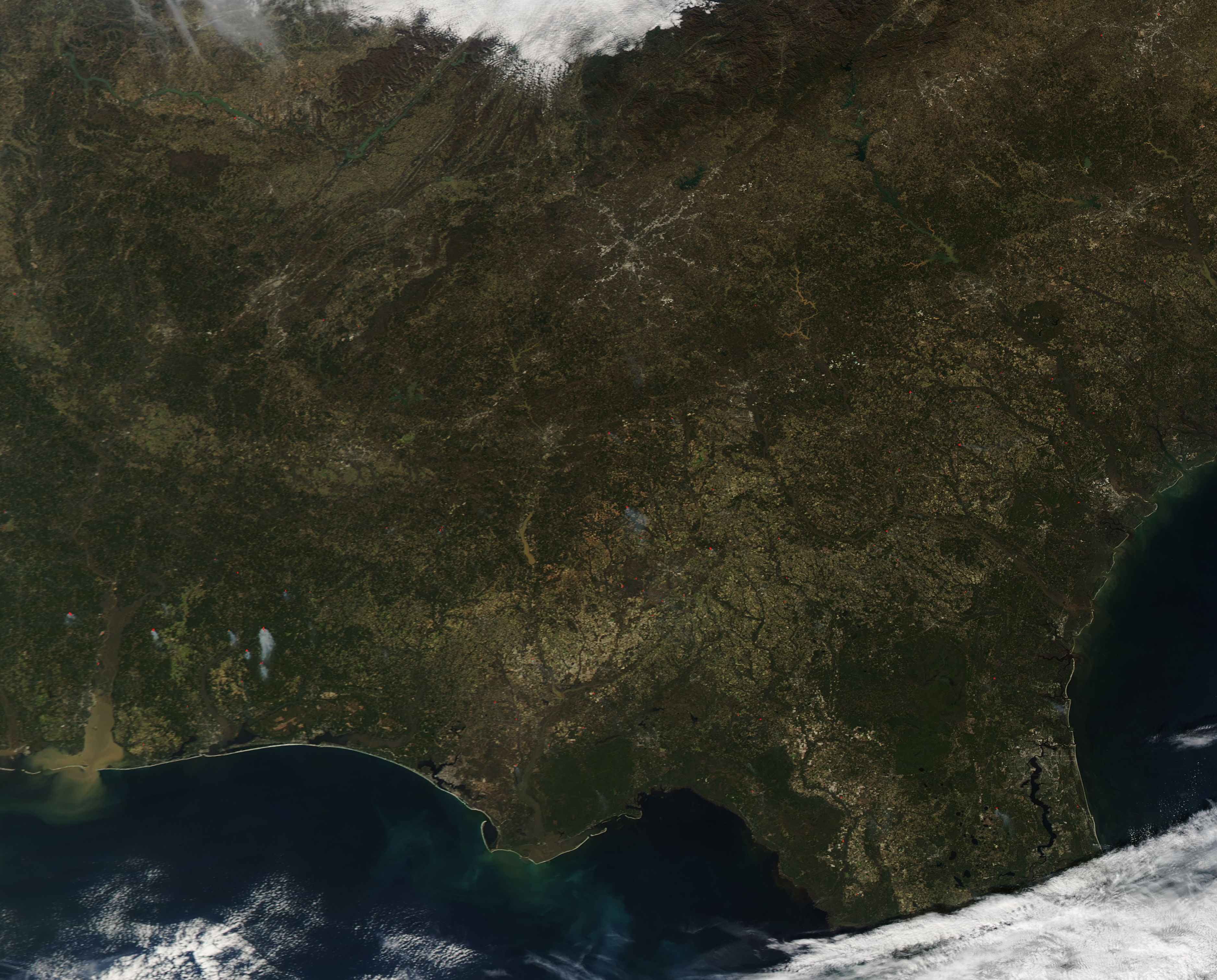
English: On January 16, 2019, the Moderate Resolution Imaging Spectroradiometer (MODIS) on board NASA’s Aqua satellite acquired a true-color image of the Southeastern United States. This broad view of a winter’s day includes six states. From west to east and north to south they are: Tennessee, North Carolina, Alabama, North Carolina, South Carolina, and northern Florida.
Several notable features are easily seen from space. The gray pixels that mark the Atlanta, Georgia metro area expand outward from the center in a sprawling, spider web-like pattern. To the northwest of Atlanta, waving folds of green and tan mark the Appalachian Mountains which stretch to the northeast from Cheaha Mountain in Alabama to Belle Island, Canada. In the southwest, a thick band of muddy water pours from Mobile Bay into the Gulf of Mexico. Heavy rains have filled both the Alabama River and the Tombigbee this winter, bringing them well above flood stage. Both rivers pour into the northern point of the Mobile-Tensaw Delta, creating flood conditions there as well. Local reports reported that in early January, heavy rains had transformed the Delta into a 13-mile-wide river as the Alabama River crested at 50.8 feet at the Claiborne Dam, one of the highest levels recorded since 1972, the year the dam was built. On January 20, the National Weather Service published warnings for continued flooding in many of Alabama’s rivers. |
||
| Дата | Снято: 16 января 2019 | ||
| Источник |
Southeastern United States (direct link)
|
||
| Автор | MODIS Land Rapid Response Team, NASA GSFC |
| This media is a product of the Aqua mission Credit and attribution belongs to the mission team, if not already specified in the "author" row |
Лицензирование
| Этот файл находится в общественном достоянии (англ. public domain), так как он был создан NASA (Национальным управлением по аэронавтике и исследованию космического пространства). Политика авторского права NASA гласит, что «Материал NASA не защищается авторским правом, если не указано иное». (См. Template:PD-USGov, страницу политики авторского права NASA или политику использования изображений JPL.) | ||
 |
Предупреждения:
|
История файла
Нажмите на дату/время, чтобы посмотреть файл, который был загружен в тот момент.
| Дата/время | Миниатюра | Размеры | Участник | Примечание | |
|---|---|---|---|---|---|
| текущий | 03:33, 17 февраля 2024 | | 3753 × 3022 (1,47 МБ) | OptimusPrimeBot | #Spacemedia - Upload of http://modis.gsfc.nasa.gov/gallery/images/image01212019_250m.jpg via Commons:Spacemedia |
Использование файла
Нет страниц, использующих этот файл.
.jpg)