Файл:Springtime Thaw in Ungava Bay (MODIS 2022-06-06).jpg

Исходный файл (2360 × 1906 пкс, размер файла: 838 КБ, MIME-тип: image/jpeg)
Этот файл находится на Викискладе. Сведения о нём показаны ниже.
Викисклад — централизованное хранилище для свободных файлов, используемых в проектах Викимедиа.
|
.jpg?uselang=ru)
Краткое описание
| Описание |
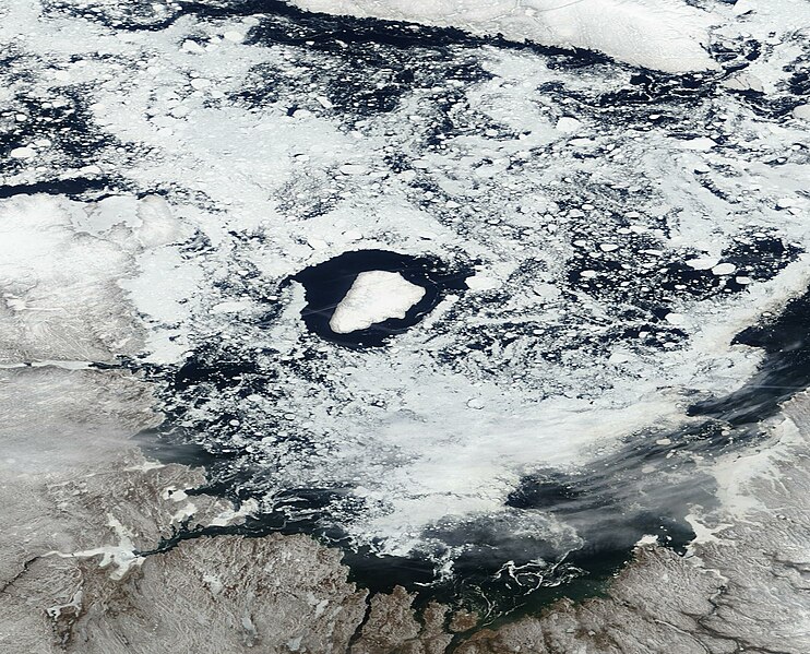
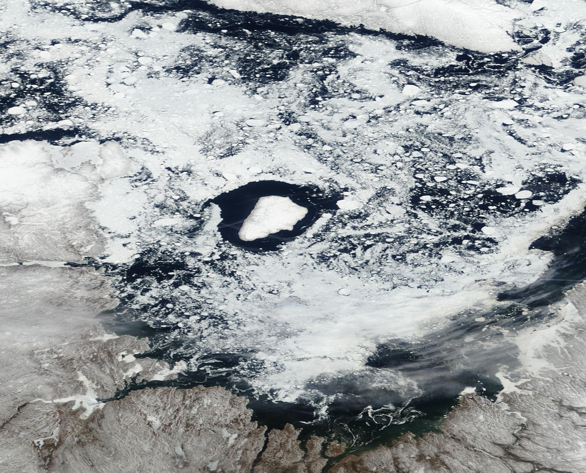
English: Sitting along the northern coastline of Quebec, Canada, Ungava Bay is a funnel-shaped, shallow body of water that lies south of the Hudson Strait, east of the Ungava Peninsula, and west of the Torngat Mountains. Thanks to its northern location, ice begins to form on Ungava Bay in November and typically stays through June. Because the chilly waters remain ice-free in the summer and early fall, the copious ice that covers the Bay in winter is first-year ice and, thanks to the extremely high tides and strong currents, the ice tends to be “rubble” ice— a type of ice made up of a jumble of ice fragments that cover the water without any particular order.
On June 2, 2022, the Moderate Resolution Imaging Spectroradiometer (MODIS) on board NASA’s Terra satellite acquired a true-color image of ice on Ungava Bay. In the image, a thin layer of winter’s snow and ice still covers the mainland of Quebec (south) while, to the north, Baffin Island wears a mantle of winter white. Some fast ice (ice connected to the shoreline) remains and copious rubble ice floats on the waters of the Bay, but large areas of open water are visible off most of the coastal areas and around Akpatok Island, in the center of the image. Accessible only by air, Akpatok Island rises out of the water as sheer cliffs that soar 500 to 800 feet (150 to 243 meters) above the sea surface. The island is an important sanctuary for cliff-nesting seabirds. In the winter, numerous ice floes around the island attract walruses and whales, making Akpatok a traditional hunting ground for native Inuit people. |
||
| Дата | Снято: 2 июня 2022 | ||
| Источник |
Springtime Thaw in Ungava Bay (direct link)
|
||
| Автор | MODIS Land Rapid Response Team, NASA GSFC |
| This media is a product of the Terra mission Credit and attribution belongs to the mission team, if not already specified in the "author" row |
Лицензирование
| Этот файл находится в общественном достоянии (англ. public domain), так как он был создан NASA (Национальным управлением по аэронавтике и исследованию космического пространства). Политика авторского права NASA гласит, что «Материал NASA не защищается авторским правом, если не указано иное». (См. Template:PD-USGov, страницу политики авторского права NASA или политику использования изображений JPL.) | ||
 |
Предупреждения:
|
История файла
Нажмите на дату/время, чтобы посмотреть файл, который был загружен в тот момент.
| Дата/время | Миниатюра | Размеры | Участник | Примечание | |
|---|---|---|---|---|---|
| текущий | 22:02, 9 января 2024 | | 2360 × 1906 (838 КБ) | OptimusPrimeBot | #Spacemedia - Upload of http://modis.gsfc.nasa.gov/gallery/images/image06062022_250m.jpg via Commons:Spacemedia |
Использование файла
Нет страниц, использующих этот файл.
.jpg)