Файл:Strait of Hormuz (MODIS 2020-12-04).jpg
Перейти к навигации
Перейти к поиску

Размер этого предпросмотра: 770 × 600 пкс. Другие разрешения: 308 × 240 пкс | 616 × 480 пкс | 986 × 768 пкс | 1280 × 997 пкс | 2235 × 1741 пкс.
Исходный файл (2235 × 1741 пкс, размер файла: 353 КБ, MIME-тип: image/jpeg)
Этот файл находится на Викискладе. Сведения о нём показаны ниже.
Викисклад — централизованное хранилище для свободных файлов, используемых в проектах Викимедиа.
|
.jpg?uselang=ru)
Краткое описание
| Описание |
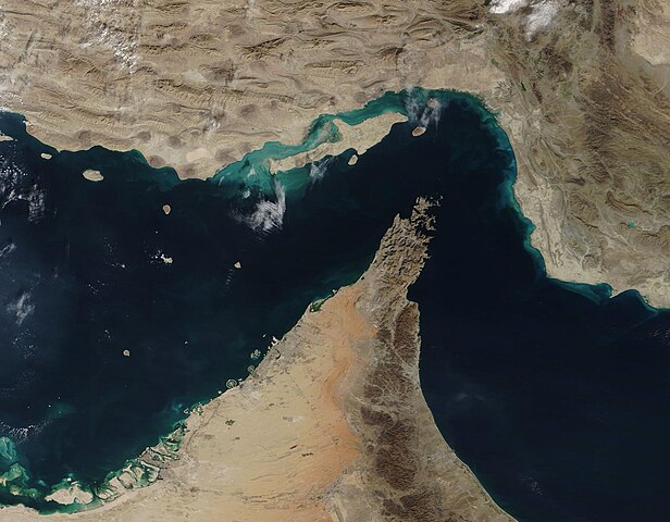
English: The narrow Strait of Hormuz lies between the Persian Gulf and the Gulf of Oman, separating Iran (north) from the Arabian Peninsula (south). Only about 21 miles (34 km) wide at the narrowest point and roughly 96 miles (155 km) long, about thirty percent of the world’s seaborne oil and nearly one-quarter of the liquified natural gas (LNG) supply passes through this strait — all on shipping lanes that measure only two-mile wide. It has been estimated that 21 million barrels of oil, with a value of 1.2 billion US dollars (USD), pass through the strait every day.
On December 2, 2020, the Moderate Resolution Imaging Spectroradiometer (MODIS) on board NASA’s Terra satellite acquired a true-color image of the Strait of Hormuz. The arid landscape of Iran sits in the north, with Qeshm Island, the largest in the Persian Gulf, just off the Iranian coast. The tiny Strait of Khuran separates the island and the mainland and bounds a wetland of international importance, recognized by Ramsar. These wetlands provide critical habitat to two globally threatened species: the Dalmatian Pelican and the Green sea turtle. In the south, the rocky and rugged Musandam Peninsula juts into the Strait of Hormuz. The tip of the peninsula is filled by the Musandam Governate, an exclave of Oman. To the south, the land on the peninsula belongs to the United Arab Emirates. |
||
| Дата | Снято: 2 декабря 2020 | ||
| Источник |
Strait of Hormuz (direct link)
|
||
| Автор | MODIS Land Rapid Response Team, NASA GSFC |
| This media is a product of the Terra mission Credit and attribution belongs to the mission team, if not already specified in the "author" row |
Лицензирование
| Этот файл находится в общественном достоянии (англ. public domain), так как он был создан NASA (Национальным управлением по аэронавтике и исследованию космического пространства). Политика авторского права NASA гласит, что «Материал NASA не защищается авторским правом, если не указано иное». (См. Template:PD-USGov, страницу политики авторского права NASA или политику использования изображений JPL.) | ||
 |
Предупреждения:
|
История файла
Нажмите на дату/время, чтобы посмотреть файл, который был загружен в тот момент.
| Дата/время | Миниатюра | Размеры | Участник | Примечание | |
|---|---|---|---|---|---|
| текущий | 19:24, 2 февраля 2024 | | 2235 × 1741 (353 КБ) | OptimusPrimeBot | #Spacemedia - Upload of http://modis.gsfc.nasa.gov/gallery/images/image12042020_250m.jpg via Commons:Spacemedia |
Использование файла
Нет страниц, использующих этот файл.
.jpg)