Файл:Streaks of Sediment in the Gulf of Khambhat (MODIS 2022-01-11).jpg
Перейти к навигации
Перейти к поиску

Размер этого предпросмотра: 760 × 599 пкс. Другие разрешения: 305 × 240 пкс | 609 × 480 пкс | 974 × 768 пкс | 1280 × 1009 пкс | 2165 × 1707 пкс.
Исходный файл (2165 × 1707 пкс, размер файла: 1,57 МБ, MIME-тип: image/jpeg)
Этот файл находится на Викискладе. Сведения о нём показаны ниже.
Викисклад — централизованное хранилище для свободных файлов, используемых в проектах Викимедиа.
|
.jpg?uselang=ru)
Краткое описание
| Описание |
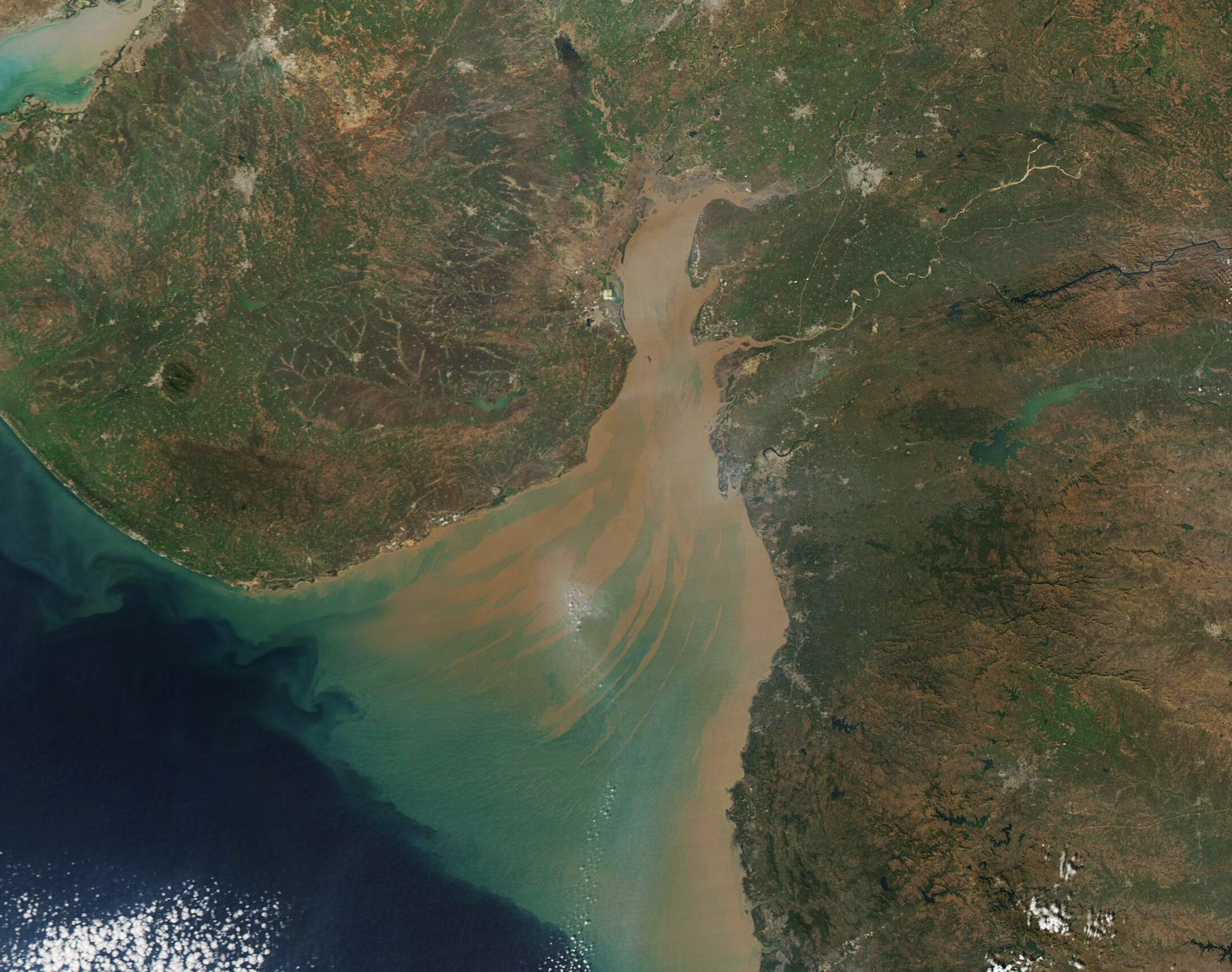
English: This gorgeous true-color image of sediment-laden water coloring the Gulf of Khambhat was acquired by the Moderate Resolution Imaging Spectroradiometer (MODIS) on board NASA’s Aqua satellite on January 10, 2022. The mud-brown sediment is thickest and nearest the surface in the northern section of the Gulf. As sediment begins to disperse and sink, the reflectivity changes and so it is seen as greenish in color. Currents leave streaks of sediment near the surface, creating a beautiful tan-and-green pattern as the waters open into the deep blue of the Arabian Sea.
The Gulf of Khambhat, which was once called the Gulf of Cambay, is a funnel-shaped indentation of the Arabian Sea that separates the large Saurashtra Peninsula and the mainland of Gujarat state, India. About 50 miles (80 km) wide at the mouth, the Gulf squeeze to a narrow 15 miles (25 km) as it courses northward. The mouth is also deeper than the northern area, with maximum water depth ranging from 98 feet (30 m) close to the Arabian Sea to 33 feet (10 m) in the north. Waters of the Gulf of Khambhat are often turbid, with sediment suspended both from the action of the tides over the shallow northern waters and from the inflow of several rivers. The Narmada, Tapi, Mahi, and Sabarmati Rivers spill into the Gulf of Khambhat, carrying both freshwater and heavy loads of suspended sediment. |
||
| Дата | Снято: 10 января 2022 | ||
| Источник |
Streaks of Sediment in the Gulf of Khambhat (direct link)
|
||
| Автор | MODIS Land Rapid Response Team, NASA GSFC |
| This media is a product of the Aqua mission Credit and attribution belongs to the mission team, if not already specified in the "author" row |
Лицензирование
| Этот файл находится в общественном достоянии (англ. public domain), так как он был создан NASA (Национальным управлением по аэронавтике и исследованию космического пространства). Политика авторского права NASA гласит, что «Материал NASA не защищается авторским правом, если не указано иное». (См. Template:PD-USGov, страницу политики авторского права NASA или политику использования изображений JPL.) | ||
 |
Предупреждения:
|
История файла
Нажмите на дату/время, чтобы посмотреть файл, который был загружен в тот момент.
| Дата/время | Миниатюра | Размеры | Участник | Примечание | |
|---|---|---|---|---|---|
| текущий | 22:22, 9 января 2024 | | 2165 × 1707 (1,57 МБ) | OptimusPrimeBot | #Spacemedia - Upload of http://modis.gsfc.nasa.gov/gallery/images/image01112022_250m.jpg via Commons:Spacemedia |
Использование файла
Нет страниц, использующих этот файл.
.jpg)